
How To Find Due South Using the Sun at Any Time of Day
by Ramkitten
This is one of many forms of navigation that doesn't require gadgets. And once you find south, you can, of course, find north, east and west.
Orienting Your Map and Yourself to South
First, you need to know the time of solar noon in the area where you're navigating.
What is solar noon?
Solar noon is the time at which the sun is highest in the sky (due south) in a particular area on a particular day. Solar noon changes slightly from day to day and rarely occurs exactly at 12:00; it's sometimes before and sometimes after, varying as much as 30 minutes from its earliest to latest times over the course of a year.
Solar noon is halfway between sunrise and sunset.
How to find the time of "solar noon" in a specific location:
You can find solar noon in several different ways.
1. You can simply look it up online. Go to Solar-Noon.com and enter the information at the bottom of the page for the location you're interested in. Then you can print out your solar noon calendar, showing the exact time of solar noon for that location for each day of the year.
2. You can use a GPS. Most models these days have a Sun/Moon feature. Go to that page on your unit and, if it's not the current (default) date you're interested in, enter the date you want. Then look for an arrow or "play" button (probably at the bottom of the screen, like on my Garmin 60Cx), which will make the sun rotate around the little compass diagram. As the sun icon moves around the compass, the time field will also change. When the sun is at south on the compass, look at the time. (Make sure your GPS is set to the correct time zone and with Daylight Savings Time turned on or off as needed.) You can also go to the time field and change it to see the sun icon reposition accordingly. By adjusting the time, you can get the sun icon to the south, and that time will be solar noon.
3. Since solar noon is midway between sunrise and sunset, you can find the time for each in a current, local paper (current and local being key here) or online and do the math. The time halfway between the two is solar noon. Most GPS units will also give sunrise/sunset information on the Sun/Moon page.
4. You can find the time of solar noon with the use of a watch and a pole (or stick or any other vertical object) surrounded by level ground. Make sure the pole is straight up and down and that you can see the shadow well. I would begin no later than 11am and, every ten or fifteen minutes, place some object, marked with the time, at the tip of the vertical object's shadow. (You can, of course, go do something else while you wait. Just keep track of the time so you don't wait too long.) When that shadow has stopped getting shorter and begins to get longer again, the object closest to the pole will be marked with the time at which the sun was highest. The shadow will then be oriented due south ... and, of course, due north as well.
Read another simple how-to about how to find direction using the sun and shadows with a similar pole method.
Note: You don't have to have the exact time of solar noon for most practical purposes of using the sun to find south. In fact, if solar noon ranges from, let's say, 12:10 to 12:40 over the course of a year in your area, using 12:30 is generally acceptable and will get you close enough to due south to be useful. So if you use one of the methods above that gives you more of an approximation than an exact time to the minute, you can still effectively use the sun and solar noon as a navigation aid.
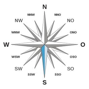
Image credit: Wikimedia Commons / CC 3.0
The Next Step: Finding South with the Sun and Solar Noon
You can simply use your hand.
 Once you know the time of solar noon in your area, check the current time. Now calculate the difference between those two times, rounding to the nearest hour or half hour.
For example, if solar noon is at about 12:30 and the current time is 10:48, then round the current time to 11:00. So the time difference for our purpose is an hour and a half.
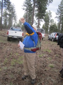
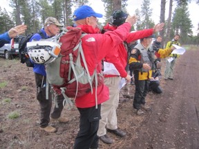
And now you're going to use your hand to determine due south.
Create a loose fist with a comfortably extended thumb. The distance between your pinky knuckle and the outer edge of your thumbnail represents 15 degress of longitude or one hour of time. (So a halfway between your pinky knuckle and your thumbnail would be thirty minutes .) This -- your hand -- is what you're going to use to measure from the current location of the sun to solar noon and, hence, towards the south, which is at 180 degrees on a compass.
Now, if it's earlier than solar noon, you'll be measuring to the right (westerly). If it's later than solar noon at the current time, you'll measure back to the left (easterly). As you measure, move your arm in an arc across the sky, as the sun would travel.
Just to cover my bases here, I'll remind you not to look directly at the sun.
That being said, place the edge of the pinky side of your hand "on" the sun and, using the edge of your extended thumb, measure over the appropriate number of hand widths (one hour each, using half a hand for half an hour) from the current location of the sun at the current time to the location and time of solar noon.
Example: If it's now 2:30pm (or or close enough to it) and solar noon is at 12:30, you'll measure two hand widths to the left (to the east) to find south, which would have been the sun's position at the time of solar noon. If it's 11:30am at the current time, you'd measure one hand width to the right (west) to find south, if solar noon is at approximately 12:30 in your area.
Measure from the Current Location of the Sun to the Position of Solar Noon
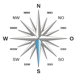
 Using Your Hand, the Sun, and Solar Noon to Find South |
 Finding South with the Sun |
Now Orient Your Map to South/North
And then you can use other types of alternative navigation to reach your destination.
 Now that you know which way is south, you can orient your map so you'll have better spacial awareness of where you are and where you're going. The vast majority of maps are printed with south towards the bottom of the map and north at the top. So turn your map accordingly and compare what you see on the map -- the terrain features, roads, powerlines, etc. -- to what you see around you.
Read More About Navigating by the Sun & Other Forms of Alternative Navigation
Using terrain to your advantage, pacing, navigating with the stars, and more....
Land Navigation Without a Compass or GPS
Use the sun, stars, terrain features and other tools and techniques to get where you want to go, without any gadgets.
Learn More About Finding Your Way Without Any Gadgets
And even without a map - This book explains how to navigate by observing birds, animals, weather patterns, vegetation, patterns of snow fields and shifting sand, and the positions of the sun, moon and stars.
 |
| Finding Your Way Without Map or Compass Dover Publications |
You might also like
STEM Subjects and EducationSTEM stands for science, technology, engineering, and mathematics. There are...
How to Treat Bed BugsArticle focused on getting rid of bed bugs in homes, apartment buildings, and...

 One-Piece Footed Pajamas for Menon 01/31/2015
 My Favorite Footed Fleece Pajamason 01/31/2015
 Ways to Save Money on Your Billson 12/27/2011
 How To Host A Local Tweetupon 07/02/2011


Comments or Questions About Navigating by the Sun?
These seemingly small tidbits of navigation can be tremendously helpful when faced with an emergency. Always good information. Thanks.
Great tips! They'll come in handy, I'm sure.
As always, your writing is so helpful to anyone who loves to hike and be outdoors. I love the photos of people actually finding south with the fist method. That book looks interesting too.
How interesting! I'll have to do this experiment. Thanks!
I learn something from you today. Interesting post. I will try myself.
Regards
That is really interesting. I'd never heard of calculating longitude using a fist. If it was late morning here in the UK, I'd be outside trying your method.
Ui, I'll have to print this and try it out on our next hike. This will come in handy teaching my kids how to navigate the low-tech way. Beats the ol' breadcrumbs trick for sure. :)
Very useful and nicely presented practical advice. Love the pictures of people actually doing it!