Across the Roof of Wales

by frankbeswick

Some intrepid walkers do most of the fourteen Munros of Snowdonia in one go and this is a challenging journey.

A Munro is a peak over three thousand feet above sea level, and there are fourteen in North Wales. It is possible to do them all in one journey, though most people who do camp out at places on route. There are variations on the route, some of which are easier than others, and in this article I will present a manageable way to do the journey, though it is not an easy one, but it is a strictly walking route.All the peaks that I describe visiting I have really ascended, though not in one marathon walk. This route is a compilation from my long experience of walking in the Welsh mountains.

Image courtesy of Hans

The Beginning

I tackled the first part of the route, the Carneddau Ridge, in high summer, and that was not the best of times, as the ridge is short of water and so all water must be carried, therefore do the route on a good cool Spring day and travel light, taking a bivouac, enough food and plenty of water. I would advise getting a good evening meal and then starting high up,  so ascend from Aber [on the North Wales coast] and camp overnight in the hills so as to get a good start. People do camp wild on the ridge. 

The first hill is Drum, a ridge of about 2500 feet with a stone shelter on top,which is where some people camp, but generally the best feature of Drum is the views, which to the south reach over the Menai Straits towards Anglesey and eastwards to the Conwy valley. But there is to be no lingering on such a journey, so you descend the col to begin the steep, grassy ascent to the next summit, Foel Fras the first of your Munros. I recall once pausing to brew some tea on the slopes,but the wind played havoc with my flame, so I contented myself with a cold drink. 

From then it is a short hop to Carnedd Uchaf, now renamed as Carnned Gwenllian after the daughter of the great Welsh prince Llewelyn. This is a pleasant summit that involves little descent and ascent from Foel Gras. Next comes the higher summit, Foel Grach, which is a straightforward ascent on, but from it you can see the bulk of Carnedd Llewelyn, Wales' second highest mountain at over 3400 feet, swelling to the south of you. This part of the ridge is rockier than the early bits are  and Carnedd Llewelyn is an impressive summit. The view to the north reaches over the Carneddau moorlands, to the east the rolling moors of Denbighshire in the distance, and to the south and west Snowdonia and its mountains. The summit of Snowdon itself peeps tantalisingly over the next range reminding you of your goal. 

The outlier on the ridge is Yr Elen, which can be reached by a detour from Carnedd Llewelyn, but on my six hour walk along the ridge the condition of my companion, who had given me cause for concern, led me to abandon that detour in order to descend as soon as possible. I had trusted his fitness, but I did not know that he had spent the previous night drinking and was dehydrated as a result. And on a scorching summer's day as well! As we were slower than I had expected because of this problem,  we had run out of water too early, and that made the last lap difficult.   

Carnedd Llewelyn leads on to Carnedd Dafyd,  named after Wales' patron saint and then by a short [only six feet long, but very narrow] ridge you gain access to Pen yr Oleu Wen, the final peak on this stage, which at 3211 feet is one foot higher than any English mountain. The steep path down winds among rocks, but we found a very welcome spring of clear fresh water, which gave us both a boost about half way down.

For most of the year a kiosk, known as the Tea Shack, is open at the point where you reach the road. This is an ideal place to get drinks and a burger, and you can fill your your water bottles in the stream that gushes out of Llyn Ogwen ahead of the next stage in the ascent. 

Cwm Idwal

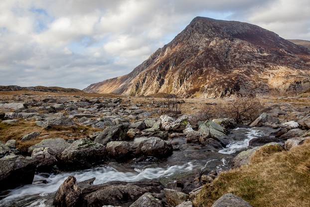
The view from Cwm Idwal to Pen yr Oleu Wen
Peter Robinson

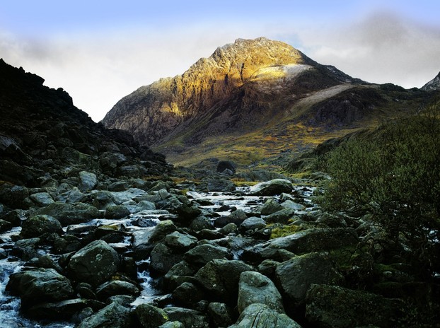
Tryfan

Tryfan
Tryfan
David Hughes

Steep, Short and Sharp

By now you have reached the Glydrs,a semi-circle of mountains criss-crossed by  paths and so a good map is very helpful. The route begins with Tryfan, a very rocky peak. The hardest route is the north ridge, but an easier way is to take the south ridge, which is more suitable for walkers not comfortable with the scrambling required for the North Ridge. I must admit that I always enjoyed the North Ridge, but at nearly sixty eight I suspect that the scrambling  is now a bit too difficult for me.  So take the route past the cafe into the stark amphitheatre of Cwm Idwal [the Idwal Valley] and follow the Miners Track upwards until you meet Bwlch Tryfan, the rocky arete between Tryfan and Glydyr Fach [Small Glydr, but still over three thousand feet.] Ascend to the summit of Tryfan and then retrace your steps downwards towards the next peak and ascend the Bristly Ridge. 

The mistake is to take the ridge up Glydr Fach directly upwards, but the walking route goes up the east side and avoids the  Bristly gullies, which involve scrambling or even rock climbing. The route takes you over the boulder-strewn summits of Glydr Fach past a lake known as Llyn Cwn, the Lake of Dogs. The only difficulty on this stretch is that whenwalking over boulders you lose momentum and can therefore tire easily. But the inspiration is provided by the fact that Snowdon, the highest peak in Wales, is now in sight.You then ascend Glydr Fawr [Big Glydr] and on a good day the views to the north down the valley of Nant Francon down towards Anglesey and the Irish Sea are a lovely sight

The final peaks in this stage of the marathon walk are Y Garn and Elidir Fawr. The walk from Glydr Fawr takes you there. Y Garn is a broad summit with a few cairns on it and it can be a  bit confusing in misty conditions.   But there is a choice of routes off. I took a route through some pleasant countryside in the Nant Peris valley, which was quite safe and dry, but you lose height and time in taking this way. It's fine if you are planning to camp, but no good if you are seeking  a record or trying a marathon walk. An alternative is to backtrack until you find a path that leads to Bwlch Dwsglydion, a route down the mountainside, but walkers are advised that this can be boggy, but it brings you out near to the next stage on the route, the Snowdon Horseshoe, a place called Pen-y-Pass [Top of the Pass] which has a cafe complex and is over a thousand feet above sea level. Walkers can refresh themselves in the cafe and you only have two thousand five hundred and eighty feet of climbing left. 

I have omitted Elidir Fawr because of difficulties caused by quarrying and hydro-electric works that make it hard to access. 

Snowdon

Snowdon
Snowdon
iankelsall

Snowdon Itself

It is called the Snowdon Horseshoe because it is a semicircle of peaks around a glacial lake

I began the Snowdon Horseshoe on a sunny day, leaving the cafe at Pen-y-Pass after a drink and a sandwich and turning towards Yr Wydfa, Wales highest peak. Very soon I turned up the path towards Crib Goch, which soon turned into a steep walk, the steepest on the route. No one forgets walking Crib Goch. It is a knife edge ridge near vertical on the Llanberis side,and for safety reasons I walked on the less steep side and used the ridge as a handrail. The sheer exhilaration of doing this ridge has stayed with me for life.Like many walkers I passed the summit point at 893 metres without noticing it, for the whole ridge is as exciting as a summit.  

Having left Crib Goch behind me I approached the Pillars, some buttresses of rock over which the purists among walkers like to scramble, but I took the walking route around them, which still involves a bit of rock work [handholds] but nothing like what you have to do on Crib Goch. The aim is   to reach a peak known  as Crib y Dysgl or Carnedd Ugain [the peak of the twentieth] after the Roman legion that had a detachment stationed at nearby Caernarvon. This is not a particularly memorable peak, but it is the last step on the way to Yr Wydfa  [Snowdon]  Wales' highest at three thousand five hundred and eighty feet. One peculiarity of Yr Wydfa is that it is sometimes the only peak in Wales whose head sticks out of the clouds,  and more than once I have stood on its summit and felt like a man on an island in a sea of clouds. Another good point is that in the tourist season there is a cafe open. It is quite a popular place whose staff ascend daily by the Snowdon mountain railway,  a narrow gauge line very popular with tourists. 

The final stage of the marathon takes you to the twin summits of Llywd, which stands opposite Crib Goch. Llywd is a mighty precipice, so walkers need to stay away  from the edge, and if they do so they are safe. The path descends and circles round to Pen-y-Pass. The marathon is over. You need though to have arranged transport or accommodation, as it is not circular and you are miles from your starting point. A good place to stay is in the village of Llanberis, which is   walk of about three miles or so downhill.       

Updated: 06/05/2018, frankbeswick
 
Thank you! Would you like to post a comment now?
14

Comments

Only logged-in users are allowed to comment. Login
DerdriuMarriner on 03/28/2024

Your comment Oct. 29, 2019, in answer to my previous question Oct. 28, 2019, indicates some familiarity with modern Welsh.

Is that familiarity describable as basic comprehension, reading, speaking and writing skills?

(Might you have an English -- ;-D -- accent in your spoken Welsh?)

frankbeswick on 10/30/2019

Thanks Derdriu. I am attempting to raise my walking speed. Maybe by spring or summer I will be ready again.

DerdriuMarriner on 10/30/2019

frankbeswick, May your exercises work as well on your balance and speed as medical treatments did on your posture!

frankbeswick on 10/29/2019

You must realize that Welsh has several dialects, and so Foel Fras is in the North Wales dialect. It means broad hill. Moel means a hill, but Celtic languages mutate, so in certain circumstances M mutates to F, giving us Foel. My Welsh is not good enough to explain any more than this.

The wind was not strong enough to knock me over on that occasion, but on another it was sufficiently strong to knock my friend Cahal over. He is lighter weight than I am. I was merely spun round by it, as it caught my haversack.That was at 2500 feet.

I am sad to say that while medical treatment has recovered my posture, my balance is still not right and my speed has not recovered, so a walk of this character is not now a possibility. But I am still hopeful and doing the exercises!

DerdriuMarriner on 10/28/2019

frankbeswick, Thank you for the photos, practicalities and products.
What does Foel Fras mean? The google translator gives "bare foal"!
Is the wind that "played havoc" with your tea break ever strong enough to knock someone over?

frankbeswick on 06/04/2018

Saxons had been coming in for many a year before Vortigern, as garrison troops,so Vortigern only perpetuated a Roman policy. Moreover, Vortigern invited the Jutes, who settled in Kent. The reason for introducing Saxons, Angles and Jutes was to hold back the Picts, who were ruthlessly raiding, plundering and slaving deep into Britain. Without the Saxons the Picts would probably have dominated and plundered much of the isle.

Veronica on 06/04/2018

Indeed it is believed that Vortigern invited the Saxons over to help him defend his lands.

frankbeswick on 06/03/2018

While the Saxons were capable of savagery towards the Britons, the Britons were capable of savagery to each other. In fact some modern thinking suggests that many Saxons were introduced by British Welsh] monarchs as mercenaries to help them fight other British kingdoms. There were not many good guys around at the time.

frankbeswick on 06/03/2018

Sorry that I have been delayed in replying, but I have been working in Cambridge and the internet at my hotel crashed.

Veronica is probably right in what she said about AE. The relationship between Saxon and Welsh is very limited. Bear in mind that the Angles and Saxons spoke different languages, and to complicate matters the Saxons were only found in the south. In the East Midlands and the north there were Angles. Moreover, Oppenheimer writing in the Blood of the British suggests that in the areas where the Saxons settled Welsh was not spoken and that the pre-Roman inhabitants in these areas spoke a language akin to German. His reason for thinking this is that the Welsh were ethically distinct from the inhabitants of East Britain as they derived from a different source. So it is all very complicated and uncertain.

Veronica on 06/03/2018

BSG that's a great question and also an interesting one.

Old English developed from the Anglo Saxon culture and Native Briton, the Angle "a" later becoming an "e" therefore Angleland - England. The Saxons were fairly savage to the native Brits who were pushed back to the edges of Britain.

Although Welsh now has the "ae" , I do not think they would have had any Saxon influence on their language as the Saxons didn't settle too much in Wales, The Saxons confined themselves more to the east and South with a few incursions in to the North of England.


You might also like

Explore The Thames Foreshore - Find Hidden Treasure

Coming to London? Why not visit the Thames foreshore and discover the fragme...

Touring North Wales

North Wales is a beautiful land steeped in history and myth. It is a land wit...


Disclosure: This page generates income for authors based on affiliate relationships with our partners, including Amazon, Google and others.
Loading ...
Error!