On exiting the forest he came to broader vistas, moorland used for sheep farming. Some of Wales' highest peaks would soon swim into view. The Carneddau Range was to Matthew's right, a ridge of peaks which makes brilliant walking. In fact, the stretch from Betws y Coed was on the edge of this chain of peaks. I walked the ridge in earlier years, so I know it well. Old memories are evoked.
The route was along a good footpath that did not gain or lose much height after the forest stretch, but gently undulated over a land of heather, bilberry and various hardy grasses. I would say that his aim was to reach the village of Capel Curig [Curig's Chapel] but all routes on that part of the way pass through there. It is a good place to stop for a snack and a rest, with two good hostelries to refresh tired walkers. But Matthew did not halt at Capel. It was a bit early to rest. The village is on a junction between the route to Nant Francon, a valley leading down to the sea and a road that leads to Mount Snowdon [Yr Wydfa] and the stark rock climbing grounds of Llanberis. At the junction he paused for a distant view of Snowdon, on that day happily mist-free. Then he moved on along the road that takes you between the rocky range of the Glydrs and the southern end of the Carneddau [pronounced carnedd aye]
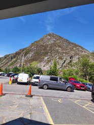
Tryfan, [prononced Tryvan] part of the Glydr range hove into view [see the picture], making a much needed focal point for tired walkers to strive for. En route he passed the waters of Llyn Ogwen [Lake Ogwen], whose tumbling outflow careers down hill into the broad U shaped valley of Nant Francon. In that narrow spot two mountain ranges come close, Carneddau and Glydrs. It was here that he stopped for lunch, making the most of the Tea Shack, a little snack bar nestled at the edge of Cwm Idwal, renowned among climbers. You get a good burger there and a drink.
The choice then is the road that runs down the east of the valley or the footpath that leads down the steep head of Nant Francon then runs on the western side. Both lead to Bethesda, the last step on the slate trail and the site of the now closed Penrhyn quarries. He chose the footpath and stepped onwards to journey's end, Bethesda. Nant means a spring and is a common place name in Wales, but Francon needs some explanation. It was in years gone by home to beasts known as afrancs, now extincted by hunting. Scholars are of the opinion that afranc was a local name for a beaver, so there is nothing mysterious about the afrancs. It was a pleasant way of finishing a long journey.
With Bethesda reached, the journey was safely over and he caught a bus to Bangor and the train home to his young wife. This journey was completed, Loch Ness is coming next. But more of that when it has been done! Watch this space.
I am an Amazon associate and earn money from qualifying purchases on this page.


 Country Shows24 days ago
 The Chelsea Flower Showon 05/24/2026
 In the new national foreston 04/16/2026
 The Boat Raceon 04/04/2026

Comments
Quercus Petraeus is the sessile oak. It is a native to Britain, but it suffered disproportionally from logging and therefore is not common now, though widespread, though thinly. In A walk with my Father I mention coming across a group of
sessile oak, but did not say much about it
The small islands in the north are very short of treès due to poor soils and strong, salty winds.
Thank you!
Online sources give as east-ponder common names for Quercus petraea Cornish oak, durmast oak, Irish oak and sessile oak.
They include no common name as Welsh oak even as they indicate Quercus petraea's "unofficial emblem" status in Cornwall and Wales.
Range maps online locate Quercus petraea all throughout the mainland United Kingdom. They manifest nothing regarding the small islands.
Might Quercus petraea maintain presences on the "little" islands? If so, by what common name might they be known?
Both kinds of name have a role,the Latin for scientific discourse and the local name which has historical roots in the vernacular
The third paragraph to the second subheading, Eighteen Miles to Go, considers that "The walk was a gentle ascent along the river side, passing through the Gwydyr [Gwydir] forest which is a designated park on the lands of the old Gwydyr estate. Much of the older planting is a reminder of the days when the forest was a timber resource, so there are numerous softwoods, notably Norway and sitka spruce, larch and abundant pine. But recent years have seen the return of deciduous woodland, so Matthew found himself ambling through young specimens of Welsh oak, birch and beech."
Online sources enumerate among common names for Quercus petraea durmast. They give no definitive etymology other than perhaps a connection to Welsh derw ("oaks") or a misreading of dun mast ("light-brown acorn").
Which possible origin story sounds likelier?
Larch and spruce were softwood plantings of non-indigenous trees. Native trees in the region are oak, beech, birch and small-leaved lime.
frankbeswick, Congratulations to your son and thank you for product lines, pretty pictures and practical information.
In particular, I appreciate the descriptive mention of area flora. But what endemic and native woody plants are there?
Would the larch and the spruces that you indicate be beloved or invasive introductions?
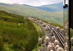
Two days ago he and I were talking about the route and he told me that the stretch from Llyn Ogwen to the head of the Nant Ffrancon valley was hard going,as the path goes along steep slopes and is quite wet underfoot.
I love walking and it has given me many happy memories, .
I admire people who trek and are fit to do so. The trail especially looks alluring for young and old. The terrain looks difficult in some places but the joy of enduring it and finishing the trail is immense.