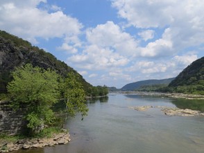
Harpers Ferry West Virginia is located at the confluence of the North Branch Potomac River and the Shenandoah River. This small town's unique geographic location has been an important influence in its history, culture, and popularity. Over the centuries, Harpers Ferry has been tempered by floods, fires, civil war battles, and other historic events.

Harpers Ferry West Virginia
Harpers Ferry is a small town in West Virginia, rich in history, culture, scenery, and outdoor recreation.
Harpers Ferry National Historical Park
Harpers Ferry National Historical Park is a sprawling complex of historical sites, woodlands, and riverfront properties in West Virginia, Maryland, and Virginia. The park has over 20 miles of hiking trails
Harpers Ferry National Historical Park is intersected by the Chesapeake and Ohio Canal National Park, Appalachian National Scenic Trail, Chesapeake and Ohio Canal National Historical Park, Potomac Heritage National Scenic Trail, and the Virginia Birding and Wildlife Trail.
Appalachian National Scenic Trail
Harpers Ferry West Virginia is a key stop along the Appalachian National Scenic Trail. Home to restaurants, cafes, and specialty shops, this friendly town offers Appalachian Trail hikers a chance to rest and buy supplies before heading back out on their trek.
The North Branch Potomac River
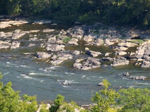
The North Branch Potomac is one of two mighty rivers that converge at Harpers Ferry. The river is a major attraction for fishermen, rafters, tubing enthusiasts, campers, and others. Popular stretches along the North Branch Potomac River include the Needles, White Horse Rapids, and many more.
Harpers Ferry Festivals
Festivals are among of the town's most popular annual events. Popular festivals in and near Harpers Ferry include the Harpers Ferry Outdoor Festival, Mountain Heritage Festivals (spring and fall), African American Heritage Festival, and others.
The Shenandoah River
The Shenandoah River flows for more than 50 miles before converging with the North Branch Potomac at Harpers Ferry, West Virginia. During periods of low water, its shallow shorelines are popular with fishermen, waders, and nature enthusiasts.
Things To Do in Harpers Ferry
Outdoor recreation and other things to do in Harpers Ferry WV
Harpers Ferry is a popular destination for hikers, bikers, fishermen, hunters, campers, birders, paddlesports participants, and other outdoor enthusiasts.
Things to do outdoors near Harpers Ferry include:
Hiking
Biking
Camping
Fishing
Hunting
Kayaking
Rafting
Tubing
Paddleboarding
Ziplining
Exploring Historical Sites
Birdwatching
Festivals
Harpers Ferry Museums
A variety of museums are located near Harpers Ferry, including:
John Brown Wax Museum
Brunswick Heritage Museum
Jefferson County Museum
Civil War Living History Museum
Harpers Ferry Toy Train Museum
Have you visited Harpers Ferry West Virginia?
The Famous Sign on Maryland Heights
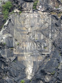
One of the most famous sites at Harpers Ferry is an advertisement that can be seen high up on Maryland Heights, just across the North Branch Potomac. Painted in the early 1900's, the ad reads "Mennen's Borated Talcum Toilet Powder."
Planning a Visit to Harpers Ferry
Before making the trip to Harpers Ferry, visitors may want to do some research in advance. Factors to consider include traffic, weather conditions, river conditions, and special events.
In addition to online sources of information, it is usually helpful to talk to someone with local knowledge.
Sources of travel information include the Harpers Ferry National Historical Park Visitor Center, Jefferson County Convention & Visitors Bureau, Appalachian Trail Conservancy, local bed and breakfasts, motels, outfitters, and others.
Visitors that plan on exploring the rivers near Harpers Ferry may also want to become familiar with stream gauge data which is available from the U.S. Geological Survey (USGS).
You might also like
The New York Botanical GardenThe New York Botanical Garden is a beautiful place to visit throughout the ye...
Forgotten Florida: Marineland Oceanarium and AquariumBefore Walt Disney World and Seaworld there was Marineland. Learn the history...





 Freshwater Fishing Basicson 07/27/2011
 How To Sell Foods at Farmers Marketson 06/04/2011


Comments
The last online information about the two high-watered barges dates from June 21, 2022. In particular, I find the article Contractor prepares to remove large runaway barge from Potomac River, by Julie E. Greene June 15, 2022, for Herald-Mail Media informative.
Greene has more detail about the large barge than the small.
The contractor, at the time of the article, indicated that the recovery plan is being worked out still for the small-barge hand tools and platform pieces that lie on the river bottom. The sunken equipment may be seen at low-water river levels.
Crews operate replacement barges for rebuilding the canal-side stone wall and restoring a towpath section since no less than a week before the Greene article.
It sounds impressive how everybody has cooperated, non-workers staying away from the site and out of the way of those trying to retrieve the large barge and the small-barge cargo and of those trying to work around McMahons Mill.
It will be interesting to visit the area after all the work is done.
Would you have any more news?
The search term White Horse Rapids North Branch Potomac brought me to the article Water Recreation in the Harpers Ferry Area on the River Explorer site.
That article calls the descent to the Potomac and Shenandoah waters meeting as "excellent whitewater canoeing" for "experienced paddlers." It describes river-bottom ledges that account for heavy rapids after the U.S. 340 Bridge. It names the most famous as Mad Dog and White Horse Rapids.
What inspires such descriptive names for these rapids -- Mad Dog a bit unsettling, White Horse very attracting and attractive -- which surely must draw many paddlers every year?
Let's hope this goes well without too much of a local impact. It's another example of how quickly conditions can become dangerous on a fast moving body of water.
The Chesapeake Bay Magazine online carries the article dated June 21, 2022, and entitled Salvage of Harpers Ferry Runaway Barge Begins.
Author Meg Walburn Viviano describes 2.3-plus inches falling during an early-May rainstorm and prompting "intense" river currents. She indicates that people along the Potomac River videoed two barges, brought in for a McMahon's Mill rehabilitation project and a Williamsport towpath stabilization, going speedily downstream.
The article mentions a four-week salvage of the larger barge (whose smaller companion was river-clear by May 12, just days after the incident). The salvage necessitates closing Potomac Street off Bakerton Road and the south end of the Potomac Street Extension/Armory Canal Trail.
The author recommends boaters staying close to the Maryland shore.
Would the incident and the subsequent removal and salvage have any negative impacts upon area environments and tourism?
Fortunately, most the town and nearby recreational areas are located on high ground. In general, water-related recreation providers take water conditions seriously and offer safety information.
Additionally, from the advanced hydrologic prediction service information on the National Weather Service (NWS) site, it notes no specific impacts until 40- and 43.5-foot crests, whose floodwaters respectively reach the Harpers Ferry train depot and the lowest part of Potomac Avenue in Brunswick MD!
Would the Harpers Ferry area not have to have really super-trained paid and volunteer crews for such floodwater ravages not to interfere at all with the inspiring, pleasant experience of visiting such a well-maintained historic site?
The advanced hydrologic prediction service that I've been accessing, through the search phrase Harpers Ferry Potomac River, on the National Weather Service site, describes historic 30-, 33-, and 33.8-foot crests on Nov. 6, 1985; Oct. 1, 1896; and Oct. 16, 1942.
It links those crests respectively with floodwaters in the Storer College exhibit building, on the second floors of Shenandoah Street buildings and in the Brunswick MD railyard.
It mentions 34.8- and 36.5-foot crests on June 1, 1889, and March 19, 1936, respectively.
As you mentioned, Harpers Ferry and the surrounding area has a long history of catastrophic flooding. Visitors will have no problem spotting evidence of previous floods. Like many rivers of the Mid Atlantic, the Potomac is not to be taken lightly, especially during flood season.
I'd meant to include in my comment below, from around May 19, that 16-, 18-, 21.5- and 24-foot crests respectively represent action, flood, moderate flood and major flood stages!
The NWS information, accessed by searching Harpers Ferry Potomac River, lists water as reaching the C&O Canal towpath on the Maryland side, across from Harpers Ferry, of the Potomac River. It mentions that the pedestrian bridge between the C&O Canal and Harpers Ferry will be closed!
That would be quite a photo to have a souvenir, right? It wouldn't rank as high as being able to experience Harpers Ferry and a well-behaved Potomac. But it would be quite historically interesting!
It intrigued me where you say "During periods of low water, its shallow shorelines are popular with fishermen, waders, and nature enthusiasts."
So I looked online under the search term "Harpers Ferry Potomac River."
The search made the first source the NWS. The National Weather Service's Advanced Hydrologic Prediction Service maintains historical and present information about low- and high-water levels of the Potomac River at Harpers Ferry. It notes 18-foot and 18-plus-foot crests for a flood stage. It observes flood-stage crests for five dates between May 19, 2011, and Dec. 17, 2018!
Wouldn't the two May dates and the one June date be during the tourist season?