Lough Corrib

by frankbeswick

Lough Corrib is a mighty lake that stands above Galway city and drains much of the Connemara region.

Due to the topography of the island of Ireland, which is saucer shaped because of the existence of a hilly rim surrounding a flat centre, there are some significant lakes, one of which is Lough Corrib, an expanse of water studded with many islands, over a thousand to be precise. Some have a history of habitation, but others are mere islets. Like all Irish lakes it is rich in fish, with eels, trout, and others which take advantage of the variety of habitats provided by the varying depth of its waters. As with many parts of Ireland, it is a location steeped in history and myth.

Lough Corrib, courtesy of Veronica

The Geography of the Lough

My family and I sat on the comfortable grass next to the River Corrib and let our gaze wander across to the west where the Atlantic Ocean stretched into the far distance.  Besides us foamed the turbulent waters of the river, as it tumbled down from the massive freshwater lough whose powerful expanse dominates the city. Not far away were the concrete storm drains, empty in Summer, but a powerful reminder that the lough has a looming menace and has endowed the city with a history of winter floods.  Human habitation often has to make accommodation with expanses of water and Galway City is no exception, for in many ways Galway is the ideal location for a coastal town, as its long history a port confirms. The lough is both an amenity and a threat.

Lough Corrib reminds me of Loch Morar in North West Scotland, a sizable lake very close to the sea, but persistently fresh  water rather than salt because of its slightly raised elevation above sea level. But Corrib is higher than Morar and so pours its discharging waters seaward at a faster rate than Morar does. The raised land is due to the effect of the cessation of the last Ice Age. The vast weight of the ice upon the land caused it to sink slightly into the Earth, but when the Ice Age concluded the land, relieved of this weight, began to spring back. This process is still going on in parts of the world, the British Isles included, and you can see it in parts of Scotland and Ireland. I once saw what is known as a raised beach in County  Donegal, the result of this process.

The lough, which is mainly in County Galway, though it has its north-eastern part in County Mayo, draws its water from the abundant rains which fall on the mountains of Galway and Mayo. The rain water flows into the three loughs of the Corrib system, the most northerly of which is Lough Carra, whose waters are said to provide one of the best, if not the best, trout fishing waters in Ireland. Carra is in Mayo, as its its companion, the mighty Lough Mask, also a great trout lake, but like Corrib studded with islands. Carra's water flows through Mask into Corrib, which is divided into a relatively shallow southern part and a deeper northern section which can attain a depth of a hundred and sixty seven feet. Due to the shallowness of the southern section the average depth is twenty one feet.

Many of the islands which strew the lough are drumlins, which are glacial features composed of clay and rocks pushed before a glacier and left behind when the glacier melted. Many of these are in the northern section, unsurprising as the glacier moved from the north. Other islands are the results of glacial dumping, as material carried by melting glaciers fell and lay in a heap on the future lake bed. One such isle, Inish na Goile, is well wooded and is a popular spot with tourists who like the woodland walks and the views of the mountains of Connemara.

Corrib

Corrib
Corrib
Veronica

The Lough in History

The name Corrib is a corruption of Lough Oiribsean or Oiribsiu, the name being a local name for a widely worshipped pagan deity, Mannanan Mac Lir. Lir was a sea god and his son Mannanan, whose name is linked to the name Man in Isle of Man, was said to ride  a chariot pulled by magical steeds across the waves. But there is very little genuine history from the area until the Middle Ages. Marine archaeologists have uncovered remains of dug-out canoes, so it seems that there was boat commerce on the lough, and as mesolithic and neolithic flint artefacts have been found in the region, it is likely that boat commerce was part of the life of the lough from an early time. A boat from the Viking age carrying three axe heads was found, but whether or not it was a Viking boat is not clear. The remains of a Victorian pleasure yacht were also located. Ireland is protective of its archaeological heritage and so special government permission to dive to the wreck sites is required.

So far no one has located any Crannogs on the lough. These are pile dwellings constructed on artificial islands, or on islands selected and enhanced for the purpose. The ancient and mediaeval Irish were expert crannog builders, so I would not be surprised were crannog remains to be discovered. 

But the mediaeval period saw some conventional structures erected on larger islands. There are remains of a mediaeval monastic building in Inish na Goile, and from the nineteenth century some peasant cottage remains are still present. Inish means island. Another name for an island is illaun, and one island on the lough is known as Ardillaun, high island.

The lough was in the territories of the Anglo-Norman Burkes [De Burgos, Bourkes] who had been awarded land in Connemara and who in 1333 finally abandoned their Anglo-Norman identity and declared themselves Irish. The Burkes were in long-term conflict with the "Ferocious" O'Flaherties and their faithful allies, the Anglo-Norman Joyces. One story is told of magical interference or assistance, depending on whether you support the Burkes or the O'Flaherties. An O'Flaherty chief had left his wife and family for safe keeping on one of the islands while he attacked the Burkes, but was defeated. The result was that his family were stranded on the islet. Enter the Sidhe, the fairies, who looked kindly on the O'Flaherties because they had respected fairy territory. The magical fair folk brought provisions to the stranded O'Flaherties until they were rescued. Make of this what you will.

The island known as Castle Kirk Island [Caislean na Circe] is near the Lough's northern shore and contains the remains of a tower house dating back t0 1118, which makes it pre-Norman. A Caislean [pronounced castleen] is a small castle. It is considered an important archaeological site because, despite its now ruined state [Thanks Cromwell!]  it is one of the oldest stone buildings in Ireland. It at one time housed and protected Grainne O'Malley, the pirate queen of the O'Malley Clan, who  was married to an O'Flaherty chief. She is sometimes miscalled Grace O'Malley. 

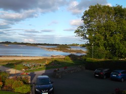
Also at the North end, in the Mayo part of Corrib, is Ashford Castle, an elegant nineteenth century country house and lodge once voted the world's best hotel. It stands on Leaf Island and is connected to the shore by a short bridge.  The picture below shows the person who provided the photographs for this article at Ashford Castle with her husband.


Corrib from the Shore

Corrib from the Shore
Veronica

Life in the Lough

The town of Oughterard on the western side of Corrib organises an annual fishing festival, a suitable activity for a lough rich in aquatic life. This is held in May and so is called the mayfly competition, where the skill celebrated is fly fishing. The quarry is brown trout and also ferox trout, a piscivorous variety of brown trout  found in glacial lakes. The festival is more than just a fishing event, for there is a whole week of attractions laid on by the town/village, many of which celebrate Irish culture.

Talk of fish raises the issue of the eels in Lough Corrib. Eels thrive in Irish waters and as the female eels migrate from the sea to inland waters to spend several years getting ready to return to the Sargasso Sea in mid-Atlantic for mating, a lough such as Corrib, nigh unto the sea, is only a short journey for them. Strong   eels can negotiate the waters of the river Corrib, and in addition, eels, which have the ability to breathe out of water can wriggle across land, which they do by squirming through wet grass from one pond or stream to another. Some of the eels in the lough can grow quite large,  as my sister discovered when she was on a boat trip on Corrib, when in the clear waters below the boat a large shape glided silently past them. The boatman told her that it was an eel and that large ones were not uncommon. It seems that large fish, probably eels, are known in some Irish lakes, a large one being seen in a lough on the Shannon system some years ago, while in Muckross Lake near Killarney in County Kerry a large fish  was noted by sonar detection in the first decade of this century.

When thinking of Corrib I was uncertain whether the proximity of the lough to the ocean had meant that Conger eels had gained access to the lough at some time in the past, but studies of eels tagged in Irish waters performed in the Sargasso have identified specimens of Anguila anguilla, the common eel, that were tagged in Corrib, so I think that the eels there are common eels. 

There is a good range of fish species in Corrib, though sadly the very rare Arctic Char is thought to be now extinct. As there are mink and otters present in the lough's environment it is possible that they were responsible for tipping a declining species over the brink of local extinction, though there may have been other factors.


Enjoying Corrib

Ashford Castle
Ashford Castle
Veronica

Amazon

paid link

I am an Amazon associate and earn money from qualifying purchases on this page.

Updated: 05/20/2022, frankbeswick
 
Thank you! Would you like to post a comment now?
14

Comments

Only logged-in users are allowed to comment. Login
frankbeswick on 01/13/2024

Most peoplevdon't know the etymology of then name, and that certainly goes for most English.

DerdriuMarriner on 01/13/2024

The last paragraph to the first subheading, The geography of the lough, brings in Inish na goile.

Online sources consider as one meaning "island in the womb." Might that be how locals specifically and east-ponders in general designate the English equivalent?

frankbeswick on 06/05/2022

The Norman identity seems to have blended into English quite easily, so there was Not much to be gained by retaining it.

frankbeswick on 06/05/2022

I think that the Buries had been marrying native Irish for so long that their sense of identity changed.

Veronica on 06/05/2022

As far as I am aware, over the centuries they "acclimatised " and blended in to consider themselves Irish. This was more especially when The Normans were no longer the ruling house.

DerdriuMarriner on 06/04/2022

Is it known why the Bourke/Burke/de Burgos family decided in 1333 -- date mentioned in your fourth paragraph under your subheading The Lough in History -- that they were Irish, not Anglo-Norman?

frankbeswick on 06/04/2022

I think that it depends on how high up the beach you are. Much of the upper reaches of Southport beach is never covered by the tide.The rest of the beach has a marine fauna,of which razor clams are common,so it must be a habitat exposed to brine.

DerdriuMarriner on 06/02/2022

Thank you, Frank and Veronica!

Do raised beaches such as Southport and St Anne's depend more upon ground or rain water for their plant life? If the former, is it in amounts sufficient for vegetation to grow but not take over the sandy surface?

(Vegetation all over the place might make some beach-goers consider razing -- ;-D -- a raised beach.)

frankbeswick on 05/29/2022

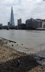
Britain is geologically tilting, with land on the South East sinking slightly, whereas in the North West, that is North West England and Western Scotland there is an upward tilt.

Southport is not a typical raised beach, as its rather expansive sands are the result of the infilling of a coastal lake or marsh with sand over millennia. Yet it is rising as it is in NW England.

I think that it is useful to describe a raised beach as a fossil beach which was once at sea level, but due to uplift of ground levels is now higher than it was at the time of its formation.

Veronica on 05/29/2022

Derdriu
The North west coast of England , near to us, has several raised beaches.
The sea at 2 of these ( St Anne's and also Southport ) never ever comes in as the beach is raised above sea level. It is a very interesting thing. We are well used to it .


You might also like

Explore The Thames Foreshore - Find Hidden Treasure

Coming to London? Why not visit the Thames foreshore and discover the fragme...

Some Scenic Areas in Northern Ireland

Northern Ireland, with its hills and loughs, is an attractive place well wort...


Disclosure: This page generates income for authors based on affiliate relationships with our partners, including Amazon, Google and others.
Loading ...
Error!