Some Scenic Areas in Northern Ireland

by frankbeswick

Northern Ireland, with its hills and loughs, is an attractive place well worth visiting

For many years people were reluctant to visit Northern Ireland because of the troubles, but since the Good Friday Agreement which was instrumental in brìnging peace, tourism has thrived in this beautiful and culturally rich part of the British Isles. The six counties of Ulster which comprise Northern Ireland [there are three counties of Ulster in the Republic] have some lovely scenery, comprising hills and mountains and loughs, two of which, Lough Erne and Lough Neagh, are large bodies of water. Northern Ireland is worth visiting.

Waterfall in the Glens of Antrim, courtesy of G Poulsen, of Pixabay.

Beginning with the South West

My first experience of Northern Ireland was when in mid September 1969 I alighted from a bus at 10:20 pm in the border village of Belcoo, County Fermanagh, en route to a Catholic theology College two miles away in the Irish Republic. It was a clear, warm night, and I was blessed by the vision of a dark sky, unsullied by city lights, and so the Milky Way spangled the firmament above. It was my first vision of the starry heavens, and I have never forgotten it. That I am starting at the south-western corner of the province rather than in the more populous east is down to the fact that the south west is  an area of which I have strong memories.It is a personal preference.

The college was on the border, just in the Republic, but it overlooked a landscape of lough and hill. The view to the north overlooked Upper Lough Macnean, an island-studded lake which is separated from Lower Lough Macnean by an isthmus. The islands seem to be drumlins, mounds of glacial material dumped by retreating glaciers. The southern border with the Irish Republic has many drumlins, though they are a phenomenon found in all glaciated areas.

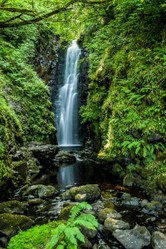
The view from over the lough was of the hills of County Fermanagh. I can recall 1300 foot Belmore Mountain, a long, flat-topped limestone ridge which resembles an escarpment and is the second highest peak in Fermanagh. The low hilly country stretched north of Lough Macnean until it reaches Lough Erne, an expanse of water quite narrow in its southern stretch, but which swells into a large and beautiful lough in the northern section.  It is a great lough for boating and there are islands with ancient remains there. 

South West Fermanagh is overlooked by Cuilcagh, a mountain oft shrouded in mist through which the border runs. One clear, cold February day I was walking by Lower Macnean when I saw Cuilcagh, snow-capped, and perfectly reflected in the tranquil lough. But I had no camera with me, so the experience remains a treasured memory to be expressed in word pictures. Cuilcagh is good walking country, and I have fond memories of hiking across its peaty summit, in a mist. It is wild land up there. In good weather the view stretches over the lowlands of County Cavan to the south, but westward you can see the Iron Mountains, old clan O' Rourke territory. I did not know then that I would marry an O'Rourke, though  she is not from that area.

North of Erne

North of mighty Lough Erne and in the north west of the province lies a stretch of land that includes the Sperrins, a range of peaks that has been classed as an outstanding area of natural beauty. When you travel the Sperrins you are conscious of voyaging through sparse moorland,. This is because the rock is very ancient, Precambrian in fact, along with some Ordovician shales of later date. The ancient rock is well-leached by the passing of ages, so the soil is not fertile, but it is a land of sheep farming, and abundant with wild life. From  vantage points on the Sperrins you can see in the hazy distance the rugged mountains of Donegal, the Derryveigh range and south of them the Blue Stack range. The pyramidal peak of Erigal. with its bare, rock-strewn slope, can be distantly seen. The Glenshane Pass cuts through the Sperrins bearing the road between Derry and Belfast. It is renowned for its inclement weather in winter, when it is hard to travel, especially when the snows sweep in across from the Atlantic.

In the centre of Northern Ireland lies Lough Neagh, a large  but not very deep lough, only forty eight feet at most.The lough is a jewel in the watery heart of Ireland. It has had a thriving eel fishery since time immemorial. Leisure boating is a popular activity on the lough. The lough is currently suffering a pollution problem, as nitrate and phosphate residues produced by farming have flowed into its waters causing invasive pond weed to grow. Work on the resolution of this problem is continuing. But the pollution problem does not detract from an appreciation of the beauty of the lough, and it still has eel fisheries which provide income to some residents of the area.

The land surrounding lough Neagh is low-lying, as Ireland is said to be saucer shaped, which means that water accumulates in the centre. The flat low land around Lough Neagh is ideal country for gentle walking. Walkers can amble along quiet roads in an agricultural countryside, where cattle are abundant in the green fields. it is a peaceful area to walk and many people love

Landscape

Evening in Northern Ireland
BrianWeiss

The East.

The East of the country contains the Mountains of Mourne. This is a range of granite peaks reaching a high point of about two thousand seven hundred feet at its highest, the peak of Slieve Donard. The granite rock is hard and non porous, which means that the soil is very wet and boggy, with a surface vegetation of heather and other bog plants. This differentiates it from the lowland bogs of the Irish midlands, which are lowland bog.But the summits of the Mournes make for great walking. Despite the difficulties of walking in territory prone to mists, which obscure vision, you can get great views from this line of peaks.The Isle of Man is easily visible in good weather if you look east from the summits, and westward you can obtain wide views across Northern Ireland. To the North the faint blue vista of the distant Scottish peaks can be glimpsed in the distance.

One  special event is held yearly in Summer, the Mourne Wall Walk. There is a dry stone wall running along the summits constructed by the water companies to prevent cattle straying into the catchment areas for the water that feeds the reservoirs that serve Belfast and fouling the city's drinking water. Once a year walkers ascend the summits and walk the course of the wall for the length of the Mourne Range. It is a great cultural attraction.Further down the slopes you get into territory where there are woodlands with plentiful wildlife. Deer and mountain hares roam freely in the landscape, along with plentiful bird life.

There are important sea loughs in the East: Carlingford Lough and Strangford Lough. Carlingford is great for boating  and angling, and you can see the Mountains of Mourne from the lake. It is a lough through which the border with the Irish Republic runs. Strangford, whose name derives from the Norse strong Lake, in recognition of the power of the current, is a beautiful lough with several islands and areas rich in wildlife.    

The North

The North East of the Province includes the large county of Antrim, much of which is a plateau. There is much beautiful land there, green fields of verdant green landscape used for pastoral farming. The glory of this landscape is the nine glens of Antrim, a tourist magnet on account of the lovely landscape that they display, where  woodlands swathe the slopes and cascading waterfalls dance their water's youthful sprint to the Irish Sea. The land is great walking country. The roads find their way through prime cattle territory well tended by farmers whose families have tended those farms, often for generations.

But the pride of the North is the Giant's Causeway, a basaltic mass of dark rock that fringes the Atlantic where its dark sturdiness defies the crashing swells that surge to their mightiest in the stormy winter months. Legend has it that the causeway and its Scottish equivalent, the basaltic mass of Fingal's Cave on the uninhabited Scottish island of Staffa were constructed to facilitate a fight between Irish and Scottish giants, who needed a bridge to enable them to meet. But the Scottish giant fled, tearing up the bridge after him, which accounts for the gap between the Irish and the Scottish basalts. In fact, the causeway was the product of lava flows around sixty million years ago when vulcanism was still rife. 

Northern Ireland is a great place to visit. I lived on its borders for a year at theological college and learned just how much the landscape had to offer. I will visit it again.

Strangford

Strangford Lough
Strangford Lough
Kensnaps

The Giant's Causeway

Giant's Causeway
Giant's Causeway
Hanswen_Fabregas

Amazon

paid link

I am an Amazon associate and hope to earn money from qualifying purchases on this page 

Updated: 12/21/2023, frankbeswick
 
Thank you! Would you like to post a comment now?
25

Comments

Only logged-in users are allowed to comment. Login
frankbeswick 23 days ago

No one decided. The custom simplybarose.

DerdriuMarriner 23 days ago

Thank you!

English Wikipedia attributes respective heights of 3,209 feet (978 meters) to England's Scafell Pike and 3,560 feet (1,085 meters) to Wales' Snowdon.

The aforementioned source attributes a height of 3,407 feet (1,038.6 meters) to Carrauntoohill. The Irish peak therefore belongs between Scafell and Snowdon.

Who decides that challenge as Three Peaks instead of Four Peaks?

(Might the Irish not want ;-D mountaineer and mountaineer-admiring ;-D crowds?)

frankbeswick 23 days ago

The highest point in Britain is 4414 feet, Ben Nevis. It is part of the Three Peaks challenge, which combines the top peaks of England, Scotland and Wales. In Ireland the highest peak is Carauntohil, there are no high peaks in Cornwall.

DerdriuMarriner 24 days ago

Jordan Romero (born July 12, 1996) climbed the highest peaks of 7 continents before age 16. He commenced climbing the highest peaks in the United States 2008-2012.

Online sources discuss climbing Cuilcagh.

Might there be a smaller-scale equivalent throughout the British Isles of mounting highest peaks?

Would there be famous highest peaks in Cornwall, England, Ireland, Scotland, Wales?

frankbeswick on 12/29/2023

In do not think that many of them give it much thought. Avfew may be interested.

DerdriuMarriner on 12/28/2023

English Wikipedia derives Neagh from Loch nEachach ("Eachaidh's lake").

It in turn links Eachaidh ("all-father, great father, horseman") to alternative names for the Dagda ("good god, shining god"), identified as chief and leader of the gods.

Might this Gaelic background be something that is familiar, remembered and respected by area inhabitants today?

frankbeswick on 12/28/2023

I am open minded on the matter, as to pass judgmentbon the issue I would have to be a
Gaelic scholar, but though I have some Gaelic My command of it is not sufficient. . I do kNow that erne is a Gaelic word for a heron.

DerdriuMarriner on 12/27/2023

Online sources offer a number of etymologies for Loughs Erne and Neagh.

What would be an etymology that you'd accept for them?

frankbeswick on 12/22/2023

Strangford Lough is a sea inlet,but Loughs Neagh and Erne are inland lakes. Carlingford Lough is a broad inlet, more like a bay, unlike Strangford, which is narrow.

blackspanielgallery on 12/22/2023

excellent images, and the advertised Rick Steves product, cannot tell if it is a book or DVD, must be great, for his material on television is excellent.


You might also like

Explore The Thames Foreshore - Find Hidden Treasure

Coming to London? Why not visit the Thames foreshore and discover the fragme...

The Tatton Show 2023

Returning to the Tatton Flower Show was a welcome return to a much loved attr...


Disclosure: This page generates income for authors based on affiliate relationships with our partners, including Amazon, Google and others.
Loading ...
Error!