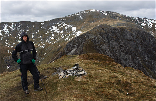
Snowdonia, the heart of mountainous Wales, has distinct mountain blocks. One of them is the Carneddau [pronounced Carnedd-I ] which stretches from the coast until the Ogwen Valley several miles to the south. There are a few farm buildings on the edges, but in the heart of the Carneddau you can be well and truly on your own. I have walked there often in my time, taking various routes, and like all parts of Wales the weather has ranged between lovely sunshine and thick snow. It is an area that repays the thoughtful walker with a great experience.

The Carneddau Ridge: Wales' great ridge walk
by frankbeswick
The walk along the Carneddau Ridge gives is a peaceful route walk that takes you through great scenery
Beginning the Walk
The journey commences on the North Wales coast at Aber, where you walk down the valley leading to Aber Falls, but branch off uphill before you reach the waterfall. The road consists of a steeply ascending lane which terminates at a gate, beyond which cars do not pass. The road swings eastwards. For those interested in history, this is a Roman road with what appears to be the ancient surface, unchanged since Agricola's legions forced their way through the Welsh hills millenia ago.For lovers of historical writing this road features in Rosemary Sutcliffe's prize winning novel, the Lantern Bearers, where the hero, Aquila, meets two Celtic warriors at Bwlch y Deufaen [ the pass of the Two Stones.] You can still see the two megaliths if you stay on the road long enough, but the path branches visibly upwards between the level summit of 2000 foot Tal y Fan to the north and Drum [2500 feet] to the south before you get to the stones. You follow the path southwards.
Drum is easy, though the path suffers water erosion and so should be trodden carefully. If you are fortunate, you can see the wild horses. An annual sight in this area is the yearly round up, with shepherds on quadbikes streaming over the hills to bring in their equine herd. This herd of Welsh mountain ponies has been here since the end of the Ice Age,scholars think. While wild, they are the property of the farmers, who sell some of them each year. This is one of the reasons for the round up, the other being checking on their health.
One year, as I walked up Drum I looked over a shallow valley and saw a whole herd peacefully grazing. A timeless scene unfolded. I could have been in the early Stone Age, for the scene must have changed little or none since then. On another trip, on a glorious summer's day, my sons and I ascended the peak after Drum, Voel Gras, and came close to a mare and her foal grazing contentedly at nearly three thousand feet up.
The Bronze Age left its mark on Drum, for in the nineteenth century a cist [pronounced kist] was unearthed. This was a small stone chamber in which was found a statue of gold, committed to the earth in honour of the deity, probably the goddess, Gaia, Dana, choose from the many names that she has had. The statue is now in the National Museum of Wales.
Snowdonia
 | Snowdonia (2nd Edition) The peaks of Snowdonia rise before you, encased in mist, their summits barely visible. The highest is Snowdon (Wyddfa) herself at 1,085 meters. The year is 1894 and the Snowdon ... |
The Middle of the Walk
From Drum you ascend to Voel Gras [Green mountain.] Along the steeply ascending route you pass the remains of two Bronze Age barrows [burial mounds] which are basically heaps of stones.As you reach the summit you see another small summit, Garnedd Uchaf [Alder Cairn] which is where the path across the range meets your route. You can descend to the East or the West, or continue your southwards progress.
You can go westwards to the outlier Yr Elen, and then this route descends to the hostelries of Bethesda. Yr Elen provides a short, but spectacular ridge walk and views over to Snowdon and the Glydrs
Once in a later year I took a route across country to the East, descending at Lllyn Dulyn [llyn,pronounced clin means lake.] This is a small tarn fed by a waterfall which cascades from great height. There is an atmosphere there, and there were small pieces of aircraft wreckage. Later on locals told me the story. Trainee pilots, often American, trained round there during the Second World War, but crossing the range, they sometimes encountered an appalling downdraught above the waterfall that drew their planes to doom. One young crew had a hair-raising escape. Their crashed aircraft teetered on the edge of the precipice, and the terrified crew could do nought but sit, unable to move lest their plane fell. Their long wait ended when a tractor could ascend the path across the ridge and hauled them to safety. But not all crews were as lucky these were.
"Did you see the ghosts? " a local man asked me.
I said that I had seen nothing. Truthfully.
But on that walk ghosts were the least of the problems. After a glorious day's walking, just after Llyn Dulyn, my right knee suddenly began to stifffen To this day I do not know what was wrong, but in an area where there is no bus or taxi [as there are no roads. ] I limped eastwards [how many miles I know not, but it felt like a lot] until I managed to find the road through the Conwy Valley. There I flagged down a bus that took me to the train station and the way home. On the way I had to keep flexing my knee to prevent it from stiffening up. Next day I applied the heat lamp and the problem was resolved.

Wales
 | The Rough Guide to Wales Full-colour throughout, The Rough Guide to Wales is the ultimate guide to this beautiful country. With 30 years experience and our trademark 'tell it like it is' writing style, ... |
The Highest Part.
After Garnedd Uchaf [now renamed Garnedd Gwenllian] you ascend Foel Grach and then you see the imposing bulk of Carnedd Llewelyn, Wales second highest mountain. You have four hundred feet to ascend, and after this the bulk of the climbing is done. After Carnedd LLewelyn [Llewelyn's Cairn, named after the resistance leader LLewelyn ap Gruffyd] you descend a little to Carned Daffyd [David's Cairn, after Wales' patron saint.
The short , but scary bit then follows. The route to the final mountain Pen yr Oleu Wen passes along a very narrow ridge, but it is but three or four feet long. Two easy steps in summer, but in ice be very careful. On Pen yr Oleu Wen you are at 3211 feet, one foot higher than anywhere in England. The view is magnificent and worth the climb. You survey the vista over the Glydrs to the massif of Yr Wydfa, at the heart of which is Snowdon, Wales' highest peak. It was on the summit of Pen yr Oleu Wen that I first experienced absolute silence one lovely day in 1973 when the sunlight bathed the mountains under a blue sky.
Yet this is an area where the weather can be grim. I have known several feet of snow fall overnight. One snowstorm in 1972 [is it so many years now?] caused is real problems. Our party leader misnavigated and led us down the wrong path in the storm. and we arrived at the wrong side of the mountain as a winter evening was falling. There were three options: bivouac overnight and have our colleagues call the rescue; walk over the mountain, but my legs were nearly gone; or walk round the mountain We chose the latter and walked through the gathering darkness to Tyn y Shanty, the hut where we were staying. I arrived a few minutes before the others, to find that our two colleagues were about to inform the mountain rescue service.
Walking in Britain
Warnings and reflections
I have had great times walking in the Carneddau, but it is a dangerous place.
Firstly, you are very much on your own. As you read, I have been there for hours without seeing another person, and so you are far from help. The Carneddau are nearly wilderness, and in winter they can be grim. Secondly, British mountain weather is very changeable, as we are an island on the edge of an ocean. You need to think about weather before you set out. Thirdly, there is no water on the ridge itself, and so you need adequate supplies before you set out, particularly in summer.
One October I and two friends ascended Drum, but the October gales made life difficult. When we reached the summit Carl, who is lightly built, was blown over by the wind. I am far better built, but the wind caught my pack and spun me round. We descended by the quickest route, thankfully with no injuries
The ridge is not circular, so if you start one end you do not return to your starting point. There is camping at Llyn Ogwen and a youth hostel, but you might want to arrange transport. There is also a cafe.
Yet when I walk the ridge I walk through nature and history. I like to see the depth of the landscape. I see the wild nature, and the human contribution to the land. I like to see the land in its historical depth, both ancient and modern. I look down over the slopes of Foel Grach and reflect on the fact that the land that I am viewing held a thriving community in the Bronze Age, before the climate worsened, and that the Bronze Age folk have left the remains of their hut circles behind them. I ponder on the homes that were, on the children born there in the warm darkness of a hut. You look over the Pen LLithyg y Wrach [the slippery hill of the witch] and wonder who she was who gave her name to a summit.
To get the best from walking you have to walk not only through nature, but through history. We walk through both space and time. It is the mind that walks.
Updated: 06/26/2017, frankbeswick
You might also like
Explore The Thames Foreshore - Find Hidden TreasureComing to London? Why not visit the Thames foreshore and discover the fragme...
Touring North WalesNorth Wales is a beautiful land steeped in history and myth. It is a land wit...
Disclosure: This page generates income for authors based on affiliate relationships with our partners, including Amazon, Google and others.


frankbeswick
432 Pages 100%Author for 13 years
 Country Shows17 days ago
 The Chelsea Flower Show26 days ago
 In the new national foreston 04/16/2026
 The Boat Raceon 04/04/2026

Comments
Maybe in Scotland. We do not have the room for ski treks across country. Fir cross country skiing you need space.
Thank you!
Cross-country skiing can be popular even in Unitedstatesian states that have ski slopes.
Is the sport practiced in the British Isles?
It depends on the weather. I always used boots. I never used skis.
The fourth sentence in the introductory paragraph advises us that "like all parts of Wales the weather has ranged between lovely sunshine and thick snow."
What kind of footwear -- boots? cross-country skis? -- does one need for a snow-covered Carneddau-Ridge walk?
I have not seen such profiles in the landscape..
Thank you!
So English Wiktionary correctly identifies carnedd with barrow but incorrectly with all else!
But is it possible that Carnedd Ridge invokes handle- or hoof-like profiles?
Spelling error, probably thevspell checker. In the previous response the word there is wronglynwritten as beer. Sorry.
Carnedd is a kind of hill, I do not think that beer is anything other than a lettrer group. Au is a plural suffix.
English Wiktionary associates carneddau with Welsh carn and -edd, respectively for haft, handle, hilt, hoof or for bairn, barrow; and for the noun ending -ment, -ness, -try, -ty.
Might an English rendering be bairn- or barrow-ness?
The next-to-last paragraph intrigues me about Foel Grach.
There may be other questions after I muster my way through online sources about Bronze Age peoples.
But, for the time being and not at all facetiously, I mull what the 14 peaks blog article Foel Grach 3202ft (976m) The Hill of Scabs SH 6887 6588 copyrighted 2015 notes as no "feature of interest" other than a big burial cairn and a "small and cheerless" mountain-refuge shelter.
The middle of last year Ragnar Jonasson offered Iceland-loving readers such as myself -- ;-D -- his latest, English-language version, Outside, of his Icelandic-language Úti.
The novel presents a mountain refuge, accessible by locked-box code to its key for serious hikers, where someone, something scary awaits a hiking quartet.
Would the 8-year-old blog description be accurate about the Foel Grach shelter?
Would that shelter be accessible without such things as keybox codes and keys? And would it be part of a nationwide hiking-shelter network -- such as in Iceland -- and would it be safe?