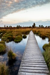
By the start of the twentieth century most traditional fen had gone, leaving four areas untouched. One of these was Wicken Fen, an area of over 240 hectares, which the National Trust preserve as a nature reserve using traditional harvesting methods. A windmill still controls water levels in the fen, and sedges [water plants] are still harvested for thatching and mat making. The most ancient fen is sedge fen, which is found right at the heart of Wicken Fen, and there visitors might if they are fortunate hear the booming call of one of Britain's rarest birds, the bittern, nicknamed the bull of the bog, a bird that nearly went extinct, but was saved by conservation efforts.
About nine thousand species of plants and animals have been found in Wicken Fen, some common,like dragonflies, but others rare, like the marsh pea, [Lathyrus palustris] whose purple flowers visitors might be fortunate to spot among the sedges. Purple loosestrife [Lythrum salicaria] adorns the fen, and you might find the rare marsh valerian [Valerian dioica] a pink flowered plant that thrives in an alkaline environment. Visitors can cycle down network of paths, walk or take an electric boat journey down the channel known as Wicken Lode.
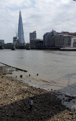
Many visitors are drawn to the Wash, which is a wonderful site of special scientific interest for the bird life above it, the sea life below it and the seals that are born and rest on its sandbanks.
Another Fenland attraction is Flag Fen, an archaeological centre which contains the relics of excavations into the ancient history of the Fens. Francis Pryor who led the excavations discovered a system of fields and drove ways leading down to the Fen along which cattle could be led to drink. He was later to discover a system of boardwalks leading into an ancient lake, into which worshippers had cast votive offerings to the deity. This practice still has echoes today in the custom of throwing coins into fountains, and it is behind the Arthurian legend that the sword Excalibur was delivered back to the Lady of the Lake when he died. Though you must be clear, there is no Arthurian connection with the Fens. Not only is Francis Pryor [now retired] an excellent writer on archaeology, he created a popular visitors' centre that is well worth a visit.
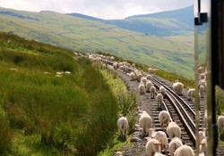
Visitors will find much scope for quiet walking down country and cycling down country lanes where they might come upon villages with mediaeval churches and traditional village inns. Ascent on these walks is rare , which makes the Fens a good place for older people to stroll.
Ely was an abbey church that survived the Reformation by being turned into a cathedral. It was erected on the orders of William the Conqueror, though his building programme would not have paid the price of the blood that he shed. But nevertheless, the building is prestigious and worth a visit. I change trains for Cambridge at Ely; the station overlooks the River Ouse, and I am always enchanted by the marina with its plethora of small boats for cruising holidays or day trips.
I find Fenland an interesting place that I would like to explore more fully in my retirement.


 Country Shows24 days ago
 The Chelsea Flower Showon 05/24/2026
 In the new national foreston 04/16/2026
 The Boat Raceon 04/04/2026
Comments
Yes. North West Britain is tilting due to the raising of land previously weighed down by glaciers, whereas the south east is sinking
Thank you for your comment below in answer to my previous observation and question.
Online sources associate a land-level rise in some places, such as (unspecified which countries of) Scandinavia, relieved of glacial- and ice-sheet weights.
Has such an occurrence happened in the part of highland Scotland without its once-permanent snow cover?
No. There was until a few years ago a patch of permanent snow in highland Scotland, but I believe that it melted.
Thank you for your comment below in answer to my previous observation and question.
Online sources associate sea-level rise with warmer water temperatures that bring about water expansion beyond their original containment, whereby causing water to go the only way possible: upward.
They correlate apparent -- not actual -- sea-level decrease with land-level rise, the latter developing from land freed from glacier and ice sheets. They give the example of Scandinavia.
Is there any part of the British Isles so cold as to have glacial and ice sheets to melt?
Not that
I know.
Thank you for your comment below in answer to my previous observation and question.
Sea-level rise appears predominantly to arise from melting ice. Is there such a thing as sea-level decrease anywhere?
It might. Creating wetlands as soft shore defences is thought to be a good method of coastal defence.
Thank you for your comment below in answer to my previous observations and questions.
Sea-level rise intrigues me. Is there anything to do against it? Might it be possible to build shorelines upward?
1: The treasure is a mystery. England was a land riven by much theft, as Saxons were not averse to stealing from Normans, so some light-fingered characters might have found some of the treasure and then held on to it.
2:Anglesey probably derives its name from the Deceangli tribe, who lived there, though its Welsh name is Mona. Deceangli is a Latin rendering of a Welsh name that might have been Dchangli. Sey or Say or Ay is a common name ending for islands in British usage, It is a Scandinavian term. It probably came from the Norse seafarers, who named many coastal places.
3: Climate change predictions are that the east of England, where the fens are, will suffer more droughts, but the north and west will suffer more storms,and this is being proved to be so. Wind frequency cannot increase in the fens as the area tends to suffer strong and regular winds anyway. Wind strength might be worsening, but it is not the main problem. The main threat to the fens is sea level rise.
frankbeswick, Thank you for the flower- and sedge-filled stroll, photos, practicalities and products, particularly those by Francis Pryor, whose King Arthur's Britain three-part DVD series I know.
Did King John really lose the royal treasure in the Wash? If so, has nothing ever been retrieved?
What is the etymology of the Welsh Anglesey?
Is the globally warmed climate change increasing the frequency and power of winds on England's fenlands? That's what's happening on the flattest lands along the coasts and Great Lakes on this side of the pond.