Tryfan and the Glyders: One of Wales' Toughest Walks

by frankbeswick

Tryfan and the Glyders make some challenging and beautiful mountain walking for the physically sturdy

There are fourteen munros in North Wales. These are peaks above 3000 feet. Of these some of the toughest walking are Tryfan and the Glyders, the word Glyder meaning clutter, for the twin peaks of Glyder Fawr and Glyder Fach have summits that are tumbled masses of ice-smashed boulders left over from the glacial ages. The other two peaks in this range are Tryfan, steep and in places challenging, and Y Garn. Together these four mountains form a walk known as the Idwal Skyline, as they surround Cwm Idwal, which you can see in the thumbnail.

Photo courtesy of Llanferes

Tryfan

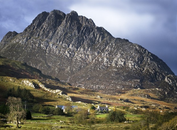
Take a look at the picture below. It is the first view I had of Tryfan. Aged twenty, I had arrived at night in a van full of students taking a weekend off college to go walking. After a night in a climbing hut that groaned as the corrugated casing contracted against the wooden walls, I awoke and went outdoors for the view. The memory stays with me today, a magnificent mountain looming down on me, crystal clear in the air cleared of dust by the previous night's rain. 

Tryfan is the eastern part of a horseshoe shaped corrie, Cwm Idwal. [What the Scots call a Corrie, the Welsh call a Cwm.] Look carefully and you can see  a line up the mountain side. This is known as the Heather Terrace and it forms the easiest way up the mountain, a steadily ascending gentle slope that eventually reaches a Col [Bwlch Tryfan] between Tryfan and Glyder Fach,  a name that means Little Glyder to compare it to its larger sibling, Glyder Fawr [Big Glyder.]

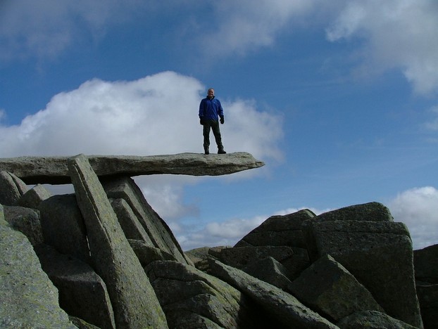
From this ridge double back on an easy scramble to the summit. However, at the top are two pillars,Adam and Eve,  on one side of which there is frightening exposure and a serious drop. Adventurous lads often jump from one to the other. What lads do to impress girls! I gave that endeavour a miss.

The toughest route up Tryfan is the North Ridge which you can see see above the Heather Terrace  which can involve scrambling, and there are on the ridge dangerous spots. Another route takes you up from Cwm Idwal. This is part of the Miners' Track. Welsh slate miners from the villages of Nant Francon used to work away at the slate mines near Llanberis, and at weekends they would walk home, crossing the mountain at the Col [pass, Bwlch in Welsh] between Tryfan and Glyder Fach and descending then to their homes for their much needed rest. 

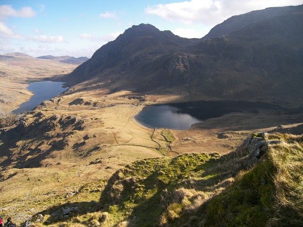
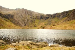
The view from the summit is glorious. You can see the whole range of North Wales, with Snowdon to the south and the mighty Carneddau to the North, and to the East the broad moorlands that stretch away towards England. You look down on two little jewels: the waters of Cwm Idwal and higher up the smaller lake of Llyn Bochlwyd.  

From the Ridge you can sometimes see the Royal Air Force practising, using the peculiar Geography of the valley below. The Ogwen Valley, by which Tryfan and its fellows stand, turns at right angles into the valley of Nant Francon, with the river that empties from Llyn Ogwen tumbling over a series of small falls at the bend. The RAF practise sharp turns around this bend and you can often see the jets like tiny red flies below you as you stand on the rocky vantage point. 

Years ago on a train I met an old woman who had grown up in the shadow of Tryfan, who told me that one of her childhood jobs on the hill farm where she was raised was to ascend Tryfan to the moorland besides it and collect whinberries, which we in England call bilberries. I got then a peek into an earlier Wales, life as it was for centuries before supermarkets. She looked a very healthy ninety plus, with a good complexion and a happy character. The outdoor life had surely been good for her.  

Tryfan

Photo courtesy of Walterl
Tryfan
Tryfan

Glyder Fach

It might be the smaller of the two, but the route up can be tough. The Bristly Ridge marches uncompromisingly upwards  from Bwlch Tryfan. Generally walkers go along the East side of the Ridge. I tried soloing to ridge one day straight up until I reached an impassible bit and had to retrace my steps. There is a rock climbing route known as the Bristly Gulleys, which I did when my joints were still flexible enough to tackle steep rock. Halcyon days!

On the jagged summit we find a curiosity, the cantilever, which you can see in the picture below. This is a perfectly balanced stone that forms a natural cantilever, on which several people can stand without tipping it. The picture is not me, by the way! Crossing the jumbled boulder field of the summit is energy sapping, as you cannot get up any rhythm in your movement.and you lose the inertia that you possess when walking on the flat or a level surface.

One minor curiosity is that a geologically observant walker can spot the pre-ice age drainage of the mountain. There are some small U shaped stream beds that suddenly terminate at the cliff above Llyn Idwal. These remnants of the glaciation before the last one used to drain further down the valley till the glacier cut back the rock face and created waterfalls. I can recall walking across one once in snow and putting my foot through the icy surface. That was chilly: cold water and cold feet at 3000 feet!

There is a minor summit not classed as a mountain between Glyder Fach and Glyder Fawr, known as Castel y Gwynt, the Castle of the winds. It makes for some jagged scrambling, but you can go round it. 

Glyder Fach

Photo courtesy of Jamie Bassnet
The cantilever on Glyder Fach

Glyder Fawr and Y Garn

Having crossed or passed Castel y Gwynt you move on to Glyder Fawr. This is a large peak from whose slopes there is  a descent to Llanberis,a  famous climbing ground that leads up to Pen y Pass, the high point of the road from which one of the routes up Snowdon begins. The view of Snowdon is impressive, and looking North your eyes can range over the impressive peak that terminates the south end of the Carneddau, Pen yr Oleu Wen, which makes a challenging ascent from the road. Looking into the distance you can rest your eyes on Mona, the Isle of Anglesey, across the fast flowing Menai Straits from the mainland. 

There is a small lake in the moorland around the peak, and this is Llyn Cwn, the Lake of Dogs. It probably acquired its name from its being the spot at which the mediaeval Welsh chiefs gathered with their hunting dogs to hunt across the high peaks, seeking whatever game was there, grouse, boar and hare most likely. The game animals have gone, as have the chiefs, but the name lingers on as a kind of ghostly hint at a wilder and earlier time. 

You can descend from Glyder Fawr to Llyn Idwal. Descend the scree covered slopes until you come to a cliff. Don't run, you might lose control and the cliff is steep. There is a deep, dark cleft splitting the cliff. This is the Devil's Kitchen. Do not dream of descending it. This is not a route for walkers, but for climbers. I tried once to ascend it, but ran into sheets of ice hanging in curtains from the frozen stream that thunders over the cliff in warmer days. The route down is to turn right at the Devil's Kitchen and follow a slowly descending path until you meet an ascending one coming from the left. Follow this down. 

A curiosity is that the cliff on which the Devil's Kitchen is located is the home to rare alpine plants, remnants of Britain's Ice Age flora.  Alpine plants rare in Britain like the cold north-facing wall of Cwm Idwal. There is the tufted, purple and mossy  saxifrages, among others, which like the rock strewn slopes of the cliff. But to see them you need a guide, as the cliffs are dangerous 

Or you can follow the walk round to reach Y Garn. This summit tends to be a bit neglected by walkers who aim for the spectacular Tryfan and the Glyders. But it is perhaps the widest summit of the range. In mist it can be confusing. I once one October tried solo walking the whole range but ran into a seriously cold wind on Y Garn, the first peak of the walk on that day. The wind was sapping my energy so I had to descend. I was doing my Philosophy Masters at the time and next week I was chatting about it before class, when the lecturer's ears pricked up. 

"You should not have gone round Widdershins" he stated. 

I was a bit surprised that a philosophy lecturer thought that a widdershins [anti-clockwise] route was the wrong way to go, but Mr Curtis was a wise man, and perhaps he knew something that I didn't. Great minds do not fit into boxes.  I will leave it at that. 

Glyder Fawr. You can see Llyn Bochlwyd and in the distance Llyn Ogwen.

Photo courtesy of Richard Taylor
Glyder Fawr
Glyder Fawr

Caution

These are not easy hills. They are great to walk on, but they can be wreathed in mist and battered by strong winds in the Autumn and Winter. In deep winter there can be ice, and North Ridge of Tryfan is the most risky of all. Take no risks in these hills. They are beautiful, but unforgiving of mistakes. Many years ago someone went up the jumbled rock field at the foot of Tryfan to commit suicide. He left his car and ascended till he found a natural cavity beneath rocks, then took the pills. It was months before the body was found. This is wild place of great beauty, but we must take it seriously.

North Wales

Snowdonia (2nd Edition)

The peaks of Snowdonia rise before you, encased in mist, their summits barely visible. The highest is Snowdon (Wyddfa) herself at 1,085 meters. The year is 1894 and the Snowdon ...

View on Amazon

North Wales

Rick Steves' Snapshot North Wales (Rick Steves Snapshot)

You can count on Rick Steves to tell you what you really need to know when traveling in North Wales.Rick Steves covers the essentials of North Wales, including Ruthin, Conwy, an...

View on Amazon

North Wales

Sixty glossy pages of information about North Wales including the Isle of Anglesey, North Wales Coastal Resorts, Snodonia National Park, Lleyn Peninsula, Conway Valley, the Vale...

View on Amazon

Updated: 01/09/2015, frankbeswick
 
Thank you! Would you like to post a comment now?
22

Comments

Only logged-in users are allowed to comment. Login
frankbeswick 12 days ago

It is likely that such an effort will be made, but keeping up with changes is not easy.

DerdriuMarriner 13 days ago

Thank you!

It's sad to ponder lost names, such as a possible Welsh equivalent for Heather Terrace, and lost meanings, such as Tryfan.

It's surprising to ponder the wide range of possible meanings that online sources present.

Might there ever be an effort to present new Welsh names for places and things with only English-named survivors?

frankbeswick 16 days ago

There is asvfarcasvI know none.

DerdriuMarriner 16 days ago

Thank you!

The Etymological Dictionary of Old Welsh by Alexander Falileyev associates Tryfan with try- ("very") and bann ("tip, top") even as it begins the tryfan entry on page 151 of its year 2000 edition with "limit"!

Is there any local indication as to whether or not "very high peak" (according to English Wikipedia) or "limit" or something else invokes the Welsh-intended meaning of Tryfan?

frankbeswick 20 days ago

Yes, you are right, the terrafenis Heather, but
I do not know the Welsh name for the feature.

DerdriuMarriner 20 days ago

Thank you for the answer March 16, 2023, to my previous, same-day question.

The Heather Terrace sounds to me like it showcases gray-purple shades from ground-hugging vegetation.

Would it have a Welsh name different from or the same as its English moniker?

frankbeswick on 03/16/2023

The greyish line is the Heather Terrace, one of the routes up the mountain.

DerdriuMarriner on 03/16/2023

The image to the left of your title has the colors in your last image of Glyder Fawr.

The computer is not cooperating about the detail other than the image looks somewhat like a gray multi-lane highway running along the side of a mountain whose peaks loom above it and its bouldery, clumpy, rocky slopes loom below it.

What would the image be of, and where would it be in this really tough -- ;-D -- walk?

frankbeswick on 01/16/2015

I know what you mean. By writing these articles I intend to share my experiences gained over many years of enjoying nature.

RuthCox on 01/15/2015

The terrain views are gorgeous! However, I doubt I would be fit enough to make the trek amid the mountains and boulders, so I shall be content with pictorial views.


You might also like

Explore The Thames Foreshore - Find Hidden Treasure

Coming to London? Why not visit the Thames foreshore and discover the fragme...

Some Scenic Areas in Northern Ireland

Northern Ireland, with its hills and loughs, is an attractive place well wort...


Disclosure: This page generates income for authors based on affiliate relationships with our partners, including Amazon, Google and others.
Loading ...
Error!