Walking Ancient Ways

by frankbeswick

Sometimes you go for a walk and you know that the route you are traveling has been used for thousands of years, and your mind gets to work as you imagine the past.

You can see without truly seeing, for you can walk along engrossed in your own thoughts without any reference to what is around you; or you can see in a shallow way, just getting mere impressions of the landscape through which you walk; or you can walk mindfully, sensitively in cognizance of the land. The young person with little previous knowledge walks with the wonder of discovery; but the older person with some knowledge of the history and geology of the land through which he/she travels can engage the mind and re-imagine the past. But all, whether young or old, can be sensitive to the feel of the landscape, to the traces of the past that lie engraved on its surface and point to the depths of time through which it has existed.

The photo above shows part of the Ridgeway, and is courtesy ofantbphotos

Old Roads

A white snake across a green hillside, says the poet Edward Thomas of a chalk  footpath. He was speaking of one of the many white serpentine ways that criss-cross England's downlands, downs being a  term for the chalk hills that stretch across southern England.  It was often said that the Romans gave us roads, but this is a myth born of classical snobbery, the belief that the Greeks and Romans were a civilising force among hordes skin clad savages. Forget the fact that the Romans had gladiator fights while the Celtic "savages" did not! There were roads in Britain long before Rome, and archaeologists have found traces of some beneath the Roman roads, showing that the Romans in some cases simply improved existing paths.

The most ancient long distance chalk path known in Britain is the Ridgeway, which is part of the longer Ickneild Way, that runs across southern Britain from Salisbury Plain in Wessex to Norfolk. The word Ickneild may be linked to the Celtic tribe the Iceni, those who were led to their doom by Boudicca [Boaddiccea] as they rebelled against atrocities by the supposedly civilized Romans. Thus it links several economically important parts of Roman Britain: Salisbury Plain, the site of  Stonehenge and its rich ritual landscape; the Thames Valley ;and Norfolk, always an area with a rich pastoral  economy and good trading connections across the North Sea.

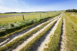
The Ridgeway is that part of the Ickneild way that runs along the chalk ridge of the Downs. There was in ancient times a great advantage to having a route along the chalk ridge, it was dry. When people see the well-drained and well farmed land of Britain they tend to think that it was ever thus,but they err, for Britain is a wet place, and thus the valleys were often muddy. Many were also forested, making travel arduous. Furthermore, the chalk ridge had  advantages, the open land meant that you could see enemies coming, and there were hill forts on the route, which meant that there were places for traders to stay and even take refuge.

The route is now a single track, but in ancient times it was a range of routes taken across the country, roughly parallel with each other. It undulates along the  gently rising and falling downs, making for a pleasant and peaceful walk.The part which is known to be very ancient runs for eighty seven miles from Overton Hill near the ancient sacred site of Avebury, A stone circle once larger than Stonehenge, to the Goring Gap, a pass in the Thames Valley where the valley narrows as it goes through an ancient glacial spillway.

Robert Macfarlane in his wonderful book, the Old Ways, [p291]  describes the Ridgeway as arguably the most sacralized terrain  in Europe, a place of vast devotional interventions in the landscape:megaliths and henges, long and round barrows,and the "cryptically simple edifice" of Silbury Hill, a man-made hill erected for a ritual purpose possibly connected with the rituals of Stonehenge, which is visible from its summit. Macfarlane regards the Stone Age landscape of the Ridgeway as landscape theatre and observes that walking is crucial to the perception of it. The approach is of great importance. Merely to whizz along on a motorbike kills the appreciation, you need to draw nigh at walking pace so as to come upon a a slow realization of the sacred significance of the place. Just as fast food rarely is fine dining, so fast experiences are  only lightly digested, wheres to be appreciated an experience sometimes must come slowly. Profundity takes time.


A View of the Downs: White Horse Hill near Uffington

White Horse Hill
White Horse Hill
Zugwang

Lonely Places

Roman roads are ancient ways, and sometimes they link up with other ancient features. One such is the Roman road that once strutted as a monument to imperial power through the Welsh hills, running from the Conway Valley to Aber, and now is a lonely testimony to ultimate failure of all empires, a place that is now frequented by hikers and farmers' vehicles. The wild horses  were there when the Romans came, were there when the Romans left and now graze the hills in which they have dwelt since the end of the Ice Age.

Macfarlane said that you can walk along ancient paths or at other times traverse them, and traversing was my first experience of  the Roman road. I  was eighteen and making an early solitary venture into the Welsh hills. Having ascended and paused to experience a small stone circle just above Pen Maen Mawr I crossed the moorland until I reached the two thousand foot eminence of Tal y Fan. Having reached the summit, I descended the south slopes until I came upon the road. There are many lonely tracks in our hills,but I had already encountered this road in literature, in The Lantern Bearers by Rosemary Sutcliffe, so the experience of place which is central  to the apprehension of an ancient track was augmented by its literary associations. The remnants of imperial grandeur in solitude speak in a melancholy way of  the failure of military power and human might. I hiked the road for a short time until I came to Bwlch y Ddeufaen, the pass of the two stones, two large megaliths through whose sacred space the military road projects itself. The feel of these megaliths differs from the feel of a military road. Stones of this kind are still the objects of respect, as if a sacredness lingers about them. They inspire me, but  speak to men not, maintaining their mute silence against the mind's interrogations.

You can access a picture of Bwlch y Ddeufaen at this web address www.stone-circles.org.uk/stone/bwlchyddeufaen.htm

Another time I walked that road and ventured up Drum  along a visible, but eroded path. It was on that path that I saw the wild horses, a herd that has dwelt in the Carneddau since the end of the Ice Age. They were a-grazing on the windswept grasses of the Welsh hills, and there was not a human artifice in sight,except the path on which I stood. I realized  that the scene was primeval, and that I was seeing what the Stone age Hunters saw so many thousand years before.It  was a lens that took me back for a few moments through time. Once on that hill a cist [stone container] was discovered containing a solid gold statue from the Bronze Age,showing that his was a mountain sacred to some god or another. Further along the ridge as you rise to Foel Gras there are two burial chambers, stone mounds now crumbling into ruin. "Why  drag all these stones up  hill just to get buried? " my ever practical younger brother demanded, but  to me it spoke of a yearning to be interred in a sacred spot in the clan's holy place. But at such moments we stand on the threshold of mystery, as the thoughts and feelings have long since died, and only the mute stones remain.


Drove Roads

A short article cannot do justice to all of Britain's drove roads, they make a lattice across Britain moving generally from northern and western regions to the prosperous lands of the south, often London,where the markets for meat and hides were large. These roads were still in use until the coming of the railways, which made transport easier and banditry harder. Yes, there was cattle rustling until the nineteenth century, and it has re-started as meat prices have risen in recent years.

Scots, Welsh and Northern English would drive whole herds of cattle and sheep southwards and westwards, bands of physically tough men used to sleeping outdoors, snatching shelter whatever the conditions, renting fields for the night to graze their herds and being ready to fight for their herds against cattle thieves, who were sometimes in league with the locals in some areas.

I have walked some drove roads, though some are unpaved ways rather than specific roads. One such is the pass between Borrowdale and Langdale in Cumbria, the English Lake District. The drovers would bring their cattle down through narrow Borrowdale and up through Langstrath to cross the soggy path across the pass, often   feeling their way through the mists then down into the small valley of Mickleden where the Drovers' Inn, the Old Dungeon Ghyll offered  a warm fire and refreshment for the night. The cattle were quartered in Oxendale, a narrow and enclosed valley. It is often wrongly believed that they were sheltering from raiding Scots, but while the Scots were notorious raiders further north, the robbers were often fellow English from the north Pennines. No racism for these guys, they robbed everyone equally.

To walk the pass while thinking about its history is to grasp the human endeavour of the strong and brave men who who made their living driving cattle. It is to ask yourself"Would I be up to this kind of life? Could I have coped with the banditry and the conditions? "

I have also walked the Portway, an ancient track which crosses the Long Mynd, a sixteen hundred foot moorland as it treks across country leading from the cattle and sheep farms of Wales to the markets of Birmingham and beyond. It is a prehistoric track that links a chain of ancient sites from Wales to Derbyshire in central England.  It was often misty as it crossed the Long Mynd, but not as arduous as some other paths were, but now it is a place for leisure horse riders and walkers, but when you walk it you feel that you are part of a stream of life traveling through time, and what for us now is a pleasant place for leisure was then a path  for people bent on staving off the poverty that ever stalked them in the poor western parts of Britain. 

Conclusion

To benefit fully from a walk,let your mind flow  freely. I like to walk through the landscape sensitive to its past, whether the distant geological the prehistoric past or nearer times. Walking is the way to appreciate the landscape to its fullness, it takes you at a speed that you can manage,allow you to see and digest the intricacies of the area through which you walk. It ensures that space, a concept of a primarily scientific character, becomes place, space with history and meaning. To walk along an ancient road sensitive to its antiquity is to set yourself within the perspective of a wider time scale and to find yourself in the great course of  time.

Updated: 07/16/2016, frankbeswick
 
Thank you! Would you like to post a comment now?
5

Comments

Only logged-in users are allowed to comment. Login
frankbeswick on 04/08/2023

Historians do not describe ancient Britons as Celts. The attribution of Celts to the Britons was the product of Victorian a ntiquarians.The road builders were simply Britons.

DerdriuMarriner on 04/07/2023

The first paragraph to your first subheading, Old Roads, considers that "There were roads in Britain long before Rome, and archaeologists have found traces of some beneath the Roman roads, showing that the Romans in some cases simply improved existing paths."

That road-building commitment makes me think of the Inca Empire in ancient South America.

The Inca peoples perhaps rivaled the Romans in that commitment. They seem to have come from nowhere -- one of my professors with a double doctorate in Anthropology and Linguistics suggested errant Mayans -- and to have hidden their native language.

Runa Simi ("the language of the people") -- so unkindly called Quechua by the Conquerors since that word means "to steal" -- was the language of one of the Inca's ruled populations.

Perhaps the Inca too worked their roads across pre-existing paths of no longer known peoples.

Who would the peoples -- Celts? -- have been who built the roads that Romans would take credit for?

frankbeswick on 07/17/2016

You make me realize that I am fortunate. I have hiked alone in Britain,Ireland, Crete, Norway and Portugal and never seen any trouble or suffered any attempt at robbery.

blackspanielgallery on 07/16/2016

You are fortunate to be able to take such walks. Here one would fear coming across those who might rob in a lonely place. And, in this area there are few paths with no cars where solitude might be possible, and the peace would not easily be shattered. Yet we have bayous which can be traveled by small boat, and I suppose paddling along would be quite rewarding. But there one must be vigilant of snakes and alligators, among the critters. Ah, the bayous make foot paths in the wilderness difficult, for they interrupt any effort to have a long dry path. And the land itself is swamp, not firm.

You might also like

Explore The Thames Foreshore - Find Hidden Treasure

Coming to London? Why not visit the Thames foreshore and discover the fragme...

Some Scenic Areas in Northern Ireland

Northern Ireland, with its hills and loughs, is an attractive place well wort...


Disclosure: This page generates income for authors based on affiliate relationships with our partners, including Amazon, Google and others.
Loading ...
Error!