What do you do when you get promotion at work? You have a week's free time between the conclusion of your previous role and the start of three weeks training for your new job. Do you crash out with a few days lazing around, getting up late and vegetating before the television? Or do you take the opportunity to walk across Scotland? You have a week and the journey takes four days.It is doable. This was the choice faced by my youngest son, and as an ardent walker he grasped the opportunity,
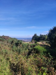
The journey is more or less a straight line between south west and north east, and it is considered wiser to begin the hike in the south west, as this means that the westerly winds, which prevail in Britain, are behind you, and so if it rains the rain will not be in your face. But if you have little time for the walk then you are advised to travel to Scotland by plane. Here's the rub, the route begins in the west, but Inverness Airport is in the East. So Matthew chose to fly to Inverness and then take a bus to the starting point in Fort William, a pleasant little highland town nestled in a small space between the waters of Loch Linnhe, a sealoch, and the Scottish mountains dominated by mighty Ben Nevis, Britain's highest mountain, whose summit looks regally down on the small settlement.
The route begins in the old fort of Fort William and passes briefly by the briny waters of Loch Linnhe before entering the Caledonian Canal, which follows the great glen to form a route for sea vessels wanting to save journey time and also avoid the turbulent waters around North Britain.It crosses an area known as Corpach, a site of a mediaeval clan battle when in 1454 Clan Cameron routed the forces of Clan Maclean.Corpach was also a place where funeral processions used to halt for a rest on their journey to the graveyards, hence the word corp for corpse.
The Caledonian Canal takes advantage of the fact that there are three lochs in the glen, going from West to East: Loch Lochy [not a large loch] Loch Oich [quite a small and narrow one] and mighty Loch Ness. The rivers between the Lochs have been canalised and are deep enough to take small vessels. The Great Glen Way follows the route of the canal and walking at first is on good quality tow paths, which for readers unfamiliar with canals were the paths along which the horses that used to pull canal barges walked.
One memorabale part of the western side of the route is Neptune's staircase, a series of locks that take the canalised river up a height of sixteen metres or so. Canoeists taking the canoe route along the glen have to portage their canoes up the paths beside the staircase and are a familiar site, and small sea vessels, often luxury craft,can still be seen using the locks as they pass.
The day passed unremarkably for Matthew, there were no difficulties in route finding and the rain, which decided to end Britain's droughty spell while he was on his walk, was not too heavy.After twenty three milles walking he arrived tired and hungry at the accomodation that he had booked for the night. The longest stretch was done, but not the hardest.


 Country Shows12 days ago
 The Chelsea Flower Show21 days ago
 In the new national foreston 04/16/2026
 The Boat Raceon 04/04/2026
Comments
Thank you for your comment below in answer to my previous observation and question.
Manx Gaelic intrigues me with its Norse component.
Might Irish and Scots Gaelic also have some Norse words even as perhaps not as much as Manx Gaelic?
I do not think that the word honour is deserved, as my Gaelic is limited. But there is Manx Gaelic, which owes some of its vocabulary to Norse.
Thank you for your comment below in answer to my previous observation and question.
Such an honor to be an Irish Gaelic speaker and to have some acquaintance with Scots Gaelic.
Is there any other kind of distinct Gaelic, such as on the islands?
I have some command of Irish Gaelic, but my Scots Gaelic is very limited.
Thank you for your comment below in answer to my previous observation and question.
The third paragraph to the first subheading, Starting the journey, advises us that "It [the route] crosses an area known as Corpach, a site of a mediaeval clan battle when in 1454 Clan Cameron routed the forces of Clan Maclean. Corpach was also a place where funeral processions used to halt for a rest on their journey to the graveyards, hence the word corp for corpse."
English Wikipedia gives A' Chorpaich as the Scots Gaelic for Corpach. It gives the English equivalent as "field of corpses."
Might that mean that -aich means "field of"?
(English Wiktionary offers it as a verb-forming suffix!)
A variety of woods can be used, but soft woods are easier to handle.
Thank you for your comment below in answer Sep. 14, 2022, to my previous observation and question Sep. 13, 2022.
Coffin-carrying appears dramatic even as it perhaps attracts body-wide pain from the wood load if not body and wood load.
Is there a preferred or traditional wood for coffins? Is it the same species in the different parts of the British Isles?
There are villages en route where you can purchase supplies,though they are fewer on the banks of Loch Ness,but you are never far away from a shop. Fort Augustus is a small town at the western tip of Loch Ness. The heaviest food you might need to carry is a packed lunch and a water bottle.
Are there places in the stops to replenish supplies, or does one have to carry multiple days food and drink?
Itbwasvsimply necessity. Coffins were borne on men's shoulders, so the coffin bearers needed to rest. It was nothing to do with the battle.