From the Tappan Zee Bridge to the Rip Van Winkle Bridge the Hudson River Valley is simply gorgeous. The Hudson River flows under these bridges, actually in both directions (at different times!) since the river is an estuary with tidal influence all the way up to Albany. We live in Red Hook, which is close to the Kingston-Rhinecliff Bridge so we drive across it on numerous occasions, and the others quite often.

Bridges of the Hudson Valley
by jptanabe
The Hudson River is a truly beautiful river, and it is crossed at numerous points by a variety of fascinating bridges along its course through the Hudson River Valley.
The Hudson River Valley has some spectacular bridges!
It's always a thrill to drive across the Hudson River towards the Catskills, especially close to sunset. In the winter there's ice on the river, which would freeze over completely if it weren't for the barges and icebreakers constantly traveling up and down. In the summer there are often sailboats, and the water sparkles in the sun. Each of the bridges has its own character, and history. So if you haven't visited them in person, check them out right here!
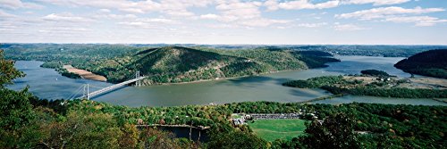
Tappan Zee Bridge
The Tappan Zee Bridge connects Tarrytown in Westchester County with Nyack in Rockland County. It's name derives from the Native American "Tappan" tribe and the Dutch word "zee," meaning a wide expanse of water (like a sea presumably!), the Hudson River being rather wide at that point.
The length of this bridge and its approaches is 16,365 feet, basically 3 miles. Tolls are collected at the Tarrytown end from eastbound traffic.
 Tappan Zee bridge, aerial view |
HISTORY OF THE BRIDGE
The idea of a bridge across the Hudson as part of a highway system that would encircle the New York-New Jersey metropolitan area had been around for a while. Delayed by the years of the Great Depression and the Second World War, serious discussion began in 1949 when the New York State Thruway Authority (NYSTA) planned to build a toll superhighway that would connect all the major cities of New York State, and would include crossing the Hudson River.
The first plans were too close to New York City (the Port Authority has jurisdiction over a 25-mile radius) and so the proposal was moved north to the Tarrytown-Nyack crossing. Although the river is very wide at this point, the plan was approved in 1951 and construction began in March 1952. The bridge was a cantilever and truss design, with the main cantilever span 1,212 feet in length, comprised of cantilever spans of 340 feet and a suspended span of 531 feet across the main channel of the river. The central cantilever span was supported by eight underwater concrete caissons (watertight structures). These caissons were hollow with air stored in various compartments. Water was periodically pumped out to achieve the desired buoyancy. This design helped to reduce costs and also to support greater loads on the bridge.
The original Tappan Zee Bridge opened to traffic on December 15, 1955, replacing the Tarrytown-Nyack ferry.
A unique feature of this bridge was the movable concrete barrier that changed the direction of traffic for the afternoon rush hour in the central (7th) lane. The changeover took about 45 minutes and involved 2 barrier moving machines working together.
Since this bridge was so long it was quite an amazing experience to drive across, with the approach section close to the surface of the wide Hudson River. In good weather it was common to see a variety of watercraft on the river, and even the skyline of New York City might be visible in the distance.
NEED FOR A NEW BRIDGE
As part of the New York State Thruway system the Tappan Zee Bridge was designed to carry heavy traffic, and that was certainly the case. However, at the beginning of the twenty-first century the bridge was in trouble.
Due to increased traffic and an aging structure (apparently bridges were built to last only 50 years, and this one passed its 50th birthday) much discussion took place over whether it would be more appropriate to fix the bridge or replace it. The replacement plan won. Construction began on the new bridge in 2013.
Since the bridge is an integral part of the New York State Thruway (I-87/I-287), the construction plan demanded that the old bridge remain in use until the new bridge was ready. This was accomplished by constructing it a few yards to the north of the existing bridge.
Of course there were some delays in the project, including the collapse of a crane buidling the new bridge that landed on the old bridge. There were several injuries but none were critical or fatal. The new bridge was opened in fall 2018.
The next problem was demolition of the old bridge. This was to have been carried out piece by piece to minimize disruption. However, first a piece of the old bridge came loose, threatening the new bridge.Then the eastern span was found to be unstable, and it had to be destroyed by explosion, in January 2019. That was quite a sight!
THE BRIDGE TODAY
The new Tappan Zee bridge is a dual-span twin bridge, This bridge has eight lanes of traffic, four in each direction.
It's really quite a cool bridge, one of the widest cable-stayed bridges in the world. And it is intended to last at least 100 years. Hopefully it will!
Of course, there continues to be controversy. This is over it's name.
Apparently the old Tappan Zee Bridge was officially named the Governor Malcolm Wilson Tappan Zee Bridge, in honor of the 50th governor of New York, Malcom Wilson. (Who knew?) Wilson finished up Nelson Rockefeller's term, when he resigned in 1973, and so he was governor for a whole year. And the Tappan Zee Bridge got his name!
Anyway, the new Tappan Zee Bridge was to be named the Governor Mario M. Cuomo Bridge. Governer Andrew Cuomo, son of Mario Cuomo, was the force behind this. Opposition arose,with petitions and new legislation being introduced, etc. Probably it is all rather irrelevant as everyone calls it the new Tappan Zee Bridge anyway!
Bear Mountain Bridge
The Bear Mountain Bridge connects Bear Mountain in Orange County to the northwestern corner of Westchester County. It is the oldest of the bridges in the Hudson River Valley south of Albany, having been opened to automobile traffic since 1924. It also carries pedestrians and cyclists traveling the Georgia-Maine Appalachian Trail across the Hudson.
A parallel wire cable suspension bridge, it is 2,332 feet in total length with a main span of 1,632 feet. With the magnificent Bear Mountain on one side and a delightful section of the river under it, this suspension bridge rates as one of the most beautiful sights along the river in my book!
HISTORY OF THE BRIDGE
The need for a bridge across the Hudson to replace the ferries became apparent in the early twentieth century as Bear Mountain State Park, which opened in 1916, became increasingly popular. The Bear Mountain Hudson River Bridge Company was formed in February 1922, to construct a bridge on state owned land. This company was to build the bridge within 3 years and then operate it for a maximum of 35 years, after which New York State would take it over.
The location of the bridge was well-suited for the construction of a suspension bridge. The river is narrow at that point, with rock formations that provided good support for piers and cables. Due to concerns that the bridge would look out of place among the beautiful mountains and river, ruining the natural beauty, the design was modified to be in accord with its surroundings.
At the time when the bridge opened to traffic on November 27, 1924, less than the 3 years allotted for its construction, it had the longest main suspension span in the world. The Bear Mountain Bridge was the beginning of a golden age of long span suspension bridge building, not only along the Hudson River but the innovative methods laid the foundation for constructing such famous bridges as the Golden Gate Bridge.

THE BRIDGE TODAY
Although the bridge lost money for most of its first 16 years in operation with less traffic than expected, current traffic is around 20,000 vehicles per day, far in excess of the projected 5,000. Today, like the other bridges operated and maintained by the NYSBA, a toll is collected in the eastbound direction only.
Pedestrians and bicyclists are welcome and heavy trucks are prohibited on the Bear Mountain Bridge. Although I don't use this bridge often, it's quite a joy to drive across and enjoy the views in this spectacular location.
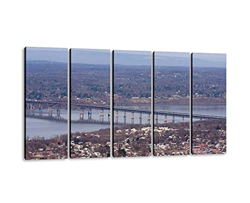
Newburgh-Beacon Bridge
The Hamilton Fish Newburgh-Beacon Bridge connects Beacon in Dutchess County with Newburgh in Orange County. There are actually two bridges: The original 4 lanes, now used for westbound traffic, opened in 1963. The parallel span, now carrying 3 lanes of eastbound traffic, opened in 1980. The bridge design is cantilever and truss, each bridge having a total length of 7,855 feet and a main cantilever span of 1,000 feet.
HISTORY OF THE BRIDGE
Ferries had crossed the Hudson River between the cities of Newburgh and Beacon since 1743. By 1910 there were 3 ferry boats, each holding 30 cars. By the 1950s, though, traffic had increased to such an extent that this was completely insufficient. In 1950 a bridge was proposed to carry this traffic and also to serve as a feeder route into the New York State Thruway (I-87) which ran past Newburgh.
Construction began in 1960, and in 1963 the bridge was opened to traffic, carrying one lane of traffic in each direction. The curved shape of the cantilever span, more attractive than conventional cantilever designs, won the bridge the 1965 "most beautiful bridge" award for long-span bridges.
One year after opening, the bridge was already carrying 25,000 vehicles a day. By the 1970s the volume of traffic across the 2-lane bridge had doubled, making it clear that expansion was necessary. In 1975, approval was given for the construction of a parallel span just south of the first bridge. Construction began in 1976, and on November 1,1980, the second bridge was opened to traffic.
THE BRIDGE TODAY
Renamed the "Hamilton Fish Newburgh-Beacon Bridge" in 1997 in honor of Hamilton Fish, former Governor of New York and United States Senator, and the five generations of the Fish family that have represented the lower Hudson Valley in state and federal government, the bridge, and I-84 of which it is part, has become a significant commercial link between New England and points west. It now carries traffic reaching as much as 65,000 vehicles per day. I can certainly testify that it's a busy stretch of road, full of trucks just speeding along!
The bridge has a pedestrian walkway which is open dawn to dusk. With convenient parking lots on the west side of the bridge, hikers, joggers, and bicyclists enjoy crossing the bridge. Tolls are charged on the Beacon side to eastbound vehicular traffic.
Mid-Hudson Bridge
The "Franklin D. Roosevelt" Mid-Hudson Bridge connects Highland in Ulster County on the west side with Poughkeepsie in Dutchess County on the east bank. Renamed in 1994 in honor of Roosevelt, who was Governor of New York at the time the bridge opened, it is generally referred to simply as the Mid-Hudson Bridge. A suspension bridge, it is 3,000 feet long with a 1,500 foot main span.

HISTORY OF THE BRIDGE
In 1923 the only bridge for vehicular traffic across the Hudson south of Albany was the Bear Mountain Bridge. Approval was given to construct a bridge across the river at Poughkeepsie. Ralph Modjeski, one of the most celebrated twentieth century American bridge designers who was already familiar with the area because of his work on renovating the Poughkeepsie Railroad Bridge, was hired to design it. His gothic design was well received and won awards for being the most beautiful suspension bridge in the region when it opened in 1930.
THE BRIDGE TODAY
In 2010 the bridge is celebrating 80 years of operation since Eleanor Roosevelt cut the ribbon on August 25, 1930. Announcing the 80th anniversary the New York State Bridge Authority stated that "While a loaf of bread cost about 5 cents in 1933, a car cost 80 cents each way and there was an extra charge of 10 cents per passenger. It cost 10 cents to walk across the bridge and a horse and rider were charged 30 cents. The toll for oxen and cows was 20 cents each and even lambs and hogs incurred a 10-cent toll."
Today tolls are collected at a toll plaza on the west bank from eastbound vehicular traffic only. The bridge carries three lanes of traffic, with the center lane used for rush hour traffic eastbound in the morning, and westbound in the late afternoon. Since 1999, with the introduction of E-ZPass, eliminating commuter tickets, and the addition of another toll lane and the addition of another toll late morning rush hour delays have been greatly reduced. There is also a pedestrian/bicycle walkway.
In 2001, a computer-controlled LED decorative lighting system was installed on the bridge. This allows the bridge to be decorated with custom light shows for significant events and holidays.
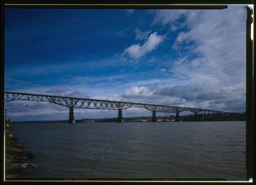
Poughkeepsie Railroad Bridge
The Poughkeepsie Railroad Bridge was built as a double-track railroad bridge. The cantilever and truss bridge opened on January 1, 1889 and went out of service on May 8, 1974. It was listed on the National Register of Historic Places in 1979 and finally reopened as the Walkway Over the Hudson pedestrian and bicycle bridge and state park in 2009.
HISTORY OF THE BRIDGE
Even before the Civil War there was discussion about constructing a bridge across the Hudson River to link New York and Pennsylvania by rail. As early as 1855 a proposal to build a railroad bridge across the river at Poughkeepsie was published in a local newspaper. Several attempts were made and failed until finally in 1886 the Manhattan Bridge Building Company was formed and succeeded in financing its construction.
The bridge was formally opened on January 1, 1889. It was considered an engineering marvel of its day. With 7 main spans, the center span measuring 546 feet, it has a total length is 6,767 feet. It was strengthened in 1912 by Ralph Modjeski to safely support the increased weight of freight trains.
The bridge remained the only Hudson River crossing south of Albany until the construction of the Bear Mountain Bridge in 1924. From the 1960s, though, the bridge began to lose it's important role. Changes in routes meant that trains no longer crossed the Hudson, with the majority of freight trains traveling on the west of the river and passenger trains to Albany and Boston on the east side. With increased maintenance costs and the bridge used less it became increasingly uneconomical to maintain. On May 8, 1974, the bridge caught fire and around 700 feet of the bridge decking on the Poughkeepsie approach was damaged.
After the fire the bridge was abandoned. Since the cost of tearing it down was prohibitive, it just waited for decades with nothing done to it apart from removal of sections of decking that were damaged in the fire since they had been falling off and damaging cars traveling under the bridge approach!
Walkway Over the Hudson
After being closed since 1974, and suffering years of abandonment, in 1998 the bridge was finally deeded to a nonprofit volunteer organization that hoped to make it into a walkway for pedestrians and cyclists. Walkway Over the Hudson was opened to the public on October 3, 2009 as a pedestrian and cyclist bridge and New York State Park.
Today the Walkway operates as part of the New York State Historic Park System. It is open from 7:00 a.m. to dusk, with parking at both ends of the bridge. Bicycles and rollerblades are permitted on the Walkway, as are pets. At both ends of the Walkway there are public restrooms, and a number of vendors selling drinks and food (including delicious icecream!).
Since its opening in October until the end of 2009, the number of visitors was approximately 450,000, much higher than the projected 267,000 visitors per year. I finally made it into that number, walking across the bridge on an overcast day in August when my sister came to visit a couple of years ago!
It isn't quite as popular a walk in the winter, with the ice on the river below, but there are always some hardy folks who still enjoy it!
 Walkway over the Hudson |
Kingston-Rhinecliff Bridge
The Kingston-Rhinecliff Bridge connects Rhinecliff in Dutchess County to Kingston in Ulster County. It is a continuous truss bridge with a total length of 7,793 feet (including all spans and approaches). The name of the Kingston-Rhinecliff Bridge is somewhat misleading, since it actually connects Kingston with the town of Rhinebeck rather than the hamlet of Rhinecliff. However, the name was taken from the ferry that used to cross the Hudson at that point and was replaced by the bridge.
HISTORY OF THE BRIDGE
Private companies had long operated the Kingston-Rhinecliff Ferry but they ceased their operation during the Second World War. When the war was over, proposals were made to build a bridge rather than resume the ferry service. However, Governor Thomas Dewey vetoed the bill proposing the bridge, pending proof that the proposed bridge was necessary, and authorized the resumption of the Kingston-Rhinecliff Ferry under the jurisdiction of the New York State Bridge Authority (NYSBA). Finally, in March 1947, the proposed Kingston-Rhinecliff Bridge was declared a "needed highway facility" by the NYSBA.
The first design was a suspension bridge like the Mid-Hudson Bridge. However, when the location of the bridge was moved north due to disputes over land use, the terrain was found to be unsuitable for construction of a suspension bridge. Instead, David Bernard Steinman designed a continuous under-deck truss bridge to cross the river.
Construction began on July 1, 1954 and the bridge first opened to traffic on February 2, 1957, earlier than anticipated since the workers needed the facility after the river froze and the ferry could not run.
 Kingston-Rhinecliff Bridge and walkers on frozen Hudson River |
THE BRIDGE TODAY
In 1999, the bridge was renamed the "George Clinton Kingston-Rhinecliff Bridge" to honor the first governor of New York State. Tolls are collected from eastbound traffic at the Kingston side of the bridge.
Significant reconstruction of the bridge took place in the 1990s and a second project was completed in 2002. This widened the traffic lanes and shoulders, as well as increasing the height of the railings. These improvements make the bridge safer for bicyclists. However, in a small car it's much more difficult to enjoy the view of the water while driving across!
Rip Van Winkle Bridge
The Rip Van Winkle Bridge connects Catskill in Greene County on the west bank with Hudson in Columbia County on the east side of the river. A cantilever and truss bridge, named after the Washington Irving character Rip Van Winkle, it measures 5,040 feet in length. The bridge opened to traffic on July 2, 1935.

HISTORY OF THE BRIDGE
In January of 1930 it was proposed to build a bridge across the Hudson River at Catskill. Although the New York State Legislature approved it, then Governor of New York Franklin Delano Roosevelt vetoed the plan arguing that in the middle of the Great Depression the state could not afford it. However, he suggested that a separate state entity be created to finance the project, which became the New York State Bridge Authority.
The original plan was to build the western approach to the bridge on land owned by Thomas Cole, an artist of the renowned Hudson River School. After considerable controversy with Thomas Cole's heirs, the design plans were modified, moving the approach to the north of the Cole property.
THE BRIDGE TODAY
Tolls are collected from eastbound traffic at the Catskill end of the bridge, at toll booths that were rebuilt in the late 1960s. Bicyclists are permitted on the bridge but they must share the two-lane roadway with motor vehicles. There are narrow sidewalks along the outboard of the superstructure that are reserved exclusively for pedestrians. These are open from dawn to dusk.
 | Hudson River Bridges (NY) (Images of America) The Hudson River Valley, an invaluable connection between New England and the rest of the colonies during the American Revolution, continues to be a major crossroads today. The ... |
Interested in the History of these Bridges?
This fascinating book documents these architectural marvels of their time. Through historical photographs, Hudson River Bridges documents how these structures across the Hudson River were built during crucial times in American history.
More about the Hudson River Bridges
- Walkway Over the Hudson - Website of the Walkway Over the Hudson State Historic Park
- The Bridges of the New York State Bridge Authority - Mainstreet Magazine
Updated: 02/03/2026, jptanabe
You might also like
Headless Horseman Hayrides and Haunted HousesHeadless Horseman Hayrides and Haunted Houses in the Mid Hudson Valley is a t...
James Blake House - Oldest in BostonThe historic neighborhood of Dorchester in Boston, Massachusetts is home to t...
Disclosure: This page generates income for authors based on affiliate relationships with our partners, including Amazon, Google and others.

 I Published “My Reflections”on 10/02/2025
 Best "Nutcracker" Movie of all Timeon 03/08/2019
 Lascaux Cave Paintingson 01/18/2018
 Great Pyramids of Gizaon 11/14/2017


Comments
Veronica, tunnelling in compressed air can produce the bends.
Thanks. They are indeed wonderful bridges, functional and beautiful!
Awesome selection of historic bridges. They are all wonderful examples of determined and skillful planning and engineering.
TY. As a Brit I would have probably said PUFF...keep..si
Yes that was it... Brooklyn Bridge and some underwater workers got The Bends I think
Thanks! Roebling designed the Brooklyn Bridge - he actually died before it was finished and his son took over the construction. I'm sure people died building that one!
Poughkeepsie is pronounced Pu-kip'-see with stress on the "kip"
Thanks! I also learned a lot about these bridges that I have driven (or walked) over many times - great to learn their history.
How is Poughkeepsie pronounced?
This is a great piece and yet again, I feel I am on a glorious world journey courtesy of our Wizzley friends.
This has everything from a description and history right down to the New York State Bridge Authority.
I once saw a fascinating TV show about the building of a 19th Century bridge over the Hudson in New York by a Mr Robling. Some men died during construction. I can't recall its name though.
Ty for posting.
This is an original topic for a Wizzley article and constitutes a useful resource for reference..
Thanks. Yes I agree. The B&W especially give a sense of the history, and some of these bridges are rather historical.
Excellent selection. It is nice to see black and white images are not neglected. Color mages are impactful, but b&w offer an older appearance, even when the image is recent.