
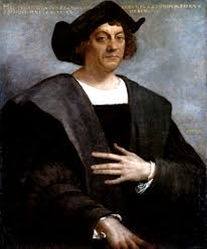
We do not know much about his own youthful travels through the mighty seas, even though we know at least three of his juvenile travels before the discovery of America. Reliable documentation exists on a journey which he made to the island of Chios around 25 years of age, between 1474 and 1475. Chios was situated opposite the coast of Turkey, and was a Genoese colony during those years. Columbus made a well-documented journey across the Atlantic Ocean in 1476. He embarked as a simple sailor on a ship named Bachalla that was directed towards the North Sea and Flanders, two countries with which Genoa had business relations.
The Bachalla passed the Strait of Gibraltar, sailing along the coast of Portugal, the Bay of Biscay and reaching the English Channel. However, in August 1476, it was attacked by French privateers near Cape St, Vincent, and then it went down. Christopher Columbus escaped by swimming, reaching the Portuguese cost. This shipwreck, which almost cost him his life, was a real stroke of luck. So Christopher arrived, albeit narrowly, in Portugal that was at the forefront of ocean exploration, and was even ahead of countries like France, Spain and England, that were engaged in wars during those years. France was struggling with Burgundy, Spain was at war against the Arabs, while England was engaged in the Wars of the Roses. The fact is that, between 1431 and 1471, thanks to Henry the Navigator, the Portuguese had sailed along the African coasts, and they had also discovered the Madeira archipelago, the Azores, the coast of Senegal and Cape Verde, Sierra Leone and the Gold Coast. After the shipwreck, Christopher did not immediately settle in Portugal, but returned to Genoa.
After the shipwreck, Columbus made a trip to England in 1477. He had spent time in Bristol before reaching Iceland, and perhaps he was looking beyond this island. It is possible that in Iceland Columbus had heard many stories about the earliest Viking enterprises to unknown lands (America). After this trip to Iceland, Columbus settled in Portugal towards the end of 1477, where he married Felipa Moniz Perestrello, a woman of noble birth, in 1479. Thanks to Pedro Correa da Cunha, Governor of the island of Porto Santo and his brother-in-law, Columbus and his wife moved to Madeira.
The historical facts and documents also contain irrefutable proof that Columbus sailed from Madeira for a trip to the Portuguese base of Elmina, which is in present day Ghana, and perhaps he knew also the Azores, the Canaries and Cape Verde. All these travels clearly demonstrate that Christopher Columbus had direct knowledge of the most valuable discoveries of the Portuguese at that time. What is certain is that Columbus’ project to crossing the Atlantic Ocean to reach the mythic Cipango (Japan), China (Catay or Northen China) and India came to fruition after his marriage and a good geographical knowledge gained after he moved to Madeira with his wife and by the subsequent explorations on the lands discovered by the Portuguese.
However, at this point, I should like to underline that an intense historiographical debate has also opened up discussions about Columbus’ intuition. According to Paolo Emilio Taviani, Columbus has the whole merit of the intuition of attempting to reach India by crossing the Atlantic Ocean, while the Portuguese historian Luis Coin Cuenca suggested that Columbus had some secret maps, acquired mysteriously from an unknown pilot. According to Professor Luis Coin Cuenca, “It was rumored at the time that Christopher Columbus's information came from the pilot of a ship that had been blown across the Atlantic while on a voyage from Spain or Portugal to England. Somewhere to the west of the island the vessel went down and a handful of diseased and starving men took to the ship's boat.
These exhausted survivors managed to reach Porto Santo. There Christopher Columbus, home between voyages and perhaps acting as governor in the absence of his brother-in-law, made the men as comfortable as possible, but in due course they all died. On his deathbed one of these, perhaps a Genoese pilot of Columbus's acquaintance, told of the trinkets he had traded for gold from an unarmed and brown-skinned people on a lush island at the extremity of an archipelago they believed to be part of the Indies. When the pilot died, Columbus quietly took possession of his charts and the heavy pilot book filled with sketches of landmarks, maps of rivers, reefs and anchorages, navigation plots and useful comments on the Books from Columbus's own library.” (John Dyson).
The question remains open, even if, as John Dyson supposed, “The idea that Columbus had a map had been common gossip during his own lifetime” ( p. 18).
Anyway, in those same years (circa 1481-1482) Columbus made direct contact with the Italian geographer Paolo Toscanelli, who, by mistake, situated Japan at a distance of 3000 nautical miles from the Canaries (actually Japan was at a distance of 10,000 nautical miles), thus reinforcing even more the appeal of Columbus’ ideas. Thanks to his wife’s family connections, Columbus managed to communicate with the Court of the king of Portugal. However, Columbus’ project was rejected by the Portuguese Commission of experts, not because they considered his theory a fanciful speculation, but because Columbus had inserted very exorbitant conditions. He demanded ennoblement, the title of Grand Admiral, Viceroyalty over all new lands discovered by him as well as 10 percent of all profits.
This proposal was rejected, but here begins another story.
Sources:
M. Sacchi, “Il Giallo della rotta di Colombo”. I viaggi di Erodoto, dicembre 1992, no 6, pp. 92-109.
In Search of the Real Christopher Columbus. Nautical Research by Dr. Luis Miguel Coin Cuenca, Edited by John Dyson, Toronto, Penguin Books limited, 1991, p. 65.
Paolo Emilio Taviani, Cristoforo Colombo. La genesi della grande scoperta, Novara, Ist. Geogr. De Agostini, 1982, p. 109, 145.
Comments
frankbeswickDec 16, 2016
frankbeswickDec 16, 2016
VeronicaDec 15, 2016
Ty and welcome to Wizzley.
solDec 15, 2016