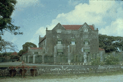
Gun Hill Signal Station was built in 1818 as one of six signal stations for external and internal security of Barbados.
Sited west of nearby Drax Hall, Gun Hill gives sweeping views of capital, Bridgetown, and Carlisle Bay, 6-plus miles (9.6 km) to southwest, from perch atop precipitous central highlands cliffs.
Fusilier Road, Gun Hill, Saint George Parish, central Barbados; Saturday, Oct. 13, 2007, 14:53: SamBlob, CC BY SA 3.0, via Wikimedia Commons @ https://commons.wikimedia.org/wiki/File:GunHillEntrance.jpg
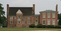
classic Jacobean architecture of Drax Hall: corner finials, steep gable roofs, casement gable windows
Drax Hall, Bowling Alley Hill, Saint Joseph Parish, east central Barbados: CC BY SA 3.0, via CulturalStudies4@Wikispaces @ http://culturalstudies4.wikispaces.com/architecture+-+barbados; Nathan Fisher, CC BY SA 4.0 International, via Wikimedia Commons @ https://commons.wikimedia.org/wiki/File:Drax-hall-plantation.gif
Charborough House is home and family seat for Richard Grosvenor Plunkett-Ernle-Erle-Drax (born January 29, 1958).
Serving since 2010 as Conservative Member of Parliament (M.P.) for South Dorset, the retired British Army Coldstream Guards officer and former reporter journeys yearly to family's working plantation on Barbados.
Dorset, South West England: John Lamper, CC BY SA 2.0, via Wikimedia Commons @ https://commons.wikimedia.org/wiki/File:Charborough_House_1.jpg
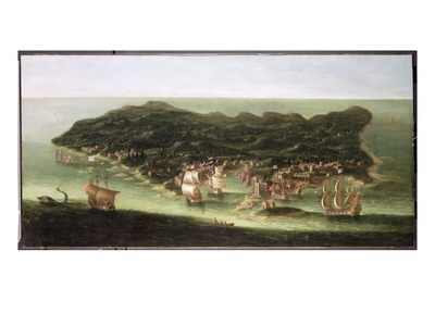
"The Island of Barbados"; ca. 1694 oil on canvas by Isaac Sailmaker (Zeilmaker) (1633 - June 28, 1721)
At time of painting, Drax Hall plantation had been in operation for over half a century (50 years-plus).
Yale Center for British Art, New Haven, southwestern Connecticut's Gold Coast: Public Domain, via Wikimedia Commons @ https://commons.wikimedia.org/wiki/File:Isaac_Sailmaker_-_The_Island_of_Barbados_-_Google_Art_Project.jpg
1686 map by Philip Lea (flourished ca. 1683-1700) with symbols for cattle mills, water mills, and windmills ("all of which are imployed in the grinding of sugar canes")
North is oriented to right. Drax Hall and the plantation's windmills (Drax Hope) are depicted (center).
Philip Lea: A new map of the Island of Barbadoes (1686): Norman B. Leventhal Map Center (Norman B. Leventhal Map Center at the BPL), CC BY 2.0, via Flickr @ https://www.flickr.com/photos/normanbleventhalmapcenter/8642371911/
the island of Barbados; 1736 hand-colored, engraved atlas map with pictorial relief; includes churches, forts, plantations, submerged rocks, windmills, etc.
North oriented to left. Drax Hall is listed in southeastern Saint George Parish (upper right of blue-outlined parish in center).
Herman Moll: The Island of Barbadoes. Divided into its Parishes (1736): Public Domain, via Wikimedia Commons @ https://commons.wikimedia.org/wiki/File:Moll_-_The_Island_of_Barbados.png


")
")


 Mailing Addresses for 2025 Form 4868 Extending 1040 and 1040SR April 15, 2026, Due Dateon 04/02/2026
 Mailing Addresses for 2025 Forms 1040 and 1040SR Filed in 2026on 03/31/2026
 Are Hawaiian Huakai Po Nightmarchers Avenging Halloween Thursday?on 10/02/2024
 Mailing Addresses for 2023 Form 4868 Extending 1040 and 1040SR April 15, 2024, Due Dateon 04/15/2024

Comments