beach at Oak Bluffs, Massachusetts: earthquake in Virginia was felt in northern Martha's Vineyard town, famous for colorful gingerbread cottages.
insular, southeastern Massachusetts: Doug Kerr, CC BY SA 2.0, via Wikimedia Commons @ https://commons.wikimedia.org/wiki/File:Beach_of_Oak_Bluffs,_Massachusetts.jpg; Doug Kerr (Dougtone), CC BY SA 2.0, via Flickr @ https://www.flickr.com/photos/7327243@N05/5705488433
Twitter was flooded with tweets within seconds after earthquake hit Mineral, Virginia.
cartoon: In Case of Earthquake, Do Not Tweet: methodshop.com, CC BY SA 2.0, via Flickr @ https://www.flickr.com/photos/methodshop/6074010519/
Map of Mid-Atlantic area affected by Virginia earthquake
M5.8 -- Virginia: Public Domain, via USGS Earthquake Hazards Program @ http://earthquake.usgs.gov/earthquakes/dyfi/events/se/082311a/us/index.html
Old Chesapeake & Ohio Depot (1880s), Historic District, Mineral, Louisa County, Virginia
104 East 1st Street, Mineral Historic District; National Register of Historic Places (NRHP) No. 05000271: William J. Grimes (William Grimes at English Wikipedia), Public Domain, via Wikimedia Commons @ https://en.wikipedia.org/wiki/File:Mineral_C&O_Depot_WJGrimes.JPG
Mineral Baptist Church, built in 1906, now houses Mineral Historic Foundation & Museum, instrumental in garnering town's approval in December 2004 for listings on Virginia Landmarks Register and on National Register of Historic Places.
51 Louisa Avenue, Mineral Historic District; National Register of Historic Places (NRHP) No. 05000271: Doug Kerr (Dougtone), CC BY SA 2.0, via Flickr @ https://www.flickr.com/photos/dougtone/6281439047/
Lake Anna State Park: former site of Goodwin Gold Mine, where gold was discovered in 1829; mining peaked in 1880s; park opened in 1983, built around Lake Anna, created in 1971 as water coolant for power stations.
from gold mining to recreation and nuclear power: Brent Hoard (phi1317), CC BY 2.0, via Flickr @ http://www.flickr.com/photos/bhoard/2643538235/
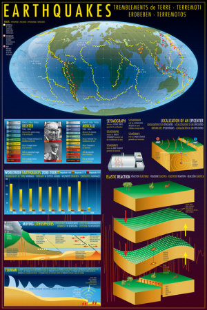
Seismic hazard map of the United States
Colors on map show levels of horizontal shaking that a 2-in-100 chance of being exceeded in a 50-year period. Shaking is expressed as a percentage of g (g is the acceleration of a falling object due to gravity).
2008 US National Seismic Hazard Maps: US Geological Survey, Public Domain, via Earthquake USGS @ http://pubs.usgs.gov/fs/2008/3018/
USGS maps of (1) Earthquakes in Virginia and Vicinity 1774-2004; (2) May 31, 1897, Giles County, Virginia Earthquake; (3) Generalized Seismic Hazard of Virginia; (4) December 9, 2003, Central Virginia Earthquake
Arthur C. Tarr and Russell L. Wheeler, Earthquakes in Virginia and Vicinity 1774-2004 (USGS Open File Report 2006): Public Domain, via USGS Publications Warehouse @ https://pubs.usgs.gov/of/2006/1017/
Central Virginia Quakemap spotlighting Mineral earthquake in geologic setting
Spotsylvania fault zone trends northeast.: Chuck M. Bailey, CC BY SA 3.0, via Wikimedia Commons @ https://en.wikipedia.org/wiki/File:Central_VA_Quakemap_by_CMBailey.jpg
Virginia's two main seismic zones: Piedmont region in central Virginia and Giles County in the southwest
Arthur C. Tarr and Russell L. Wheeler, Earthquakes in Virginia and Vicinity 1774-2004 (USGS Open File Report 2006): Public Domain, via USGS Publications Warehouse @ https://pubs.usgs.gov/of/2006/1017/
Isoseismal map of May 31, 1897, Giles County earthquake
Star (center; 37 degrees North, 80 degrees West) indicates presumed epicenter, Pearisburg, county seat of Giles County, Virginia.
C.W. Stover and Jerry L. Coffman, Seismicity of the United States, 1568-1989 (1993), Fig. 60, p. 378: Public Domain, via USGS Publications Warehouse @ https://pubs.usgs.gov/pp/1527/report.pdf
Giles County Courthouse in Pearisburg: established in 1806, Giles County built courthouse in 1836 ~ beautiful survivor of 1897 earthquake
National Register of Historic Places (NRHP) No. 82004560: Taber Andrew Bain (taberandrew), CC BY 2.0, via Flickr @ https://www.flickr.com/photos/andrewbain/2131538982/
"San Francisco in Ruins": May 28, 1906 aerial, panoramic photograph by George R. Lawrence (February 24, 1868 - December 15, 1938):
San Francisco earthquake of April 18, 1906, and devastating resulting fires are ranked among worst natural disasters in US history.
Library of Congress Prints and Photographs Division, Panoramic Photographs Collection: No known restrictions on publication, via Library of Congress Prints & Photographs Online Catalog (PPOC) @ https://www.loc.gov/pictures/item/2007663901/
August 23, 2011, earthquake damage: chimney and brick façade damage on house on Shannon Hill Road, rural Louisa, south of Mineral
August 24, 2011, photo by Francis Ashland/USGS Florence Bascom Geoscience Center: Public Domain, via U.S. Geological Society Earthquake Hazards @ https://www.usgs.gov/media/images/damage-2011-virginia-earthquake
when the earth quakes: a gathering crowd of evacuees from buildings in the town center of Kingstowne, eastern Fairfax County, Virginia
about 80 miles (128.7 kilometers) northeast of epicenter: Bethany King (Bethany L. King), CC BY ND 2.0, via Flickr @ https://www.flickr.com/photos/bethanyking/6073931111/
Four days after Mineral earthquake, Hurricane Irene slammed Virginia's east coast as aftershocks continued: three deaths and estimated $39 million in damage/emergency costs, but Mineral was spared a second onslaught.
morning after Irene at Gloucester Point, southeastern Virginia; August 28, 2011, 18:44:16, by Janet Krenn (VASG): Virginia Sea Grant, CC BY ND 2.0, via Flickr @ https://www.flickr.com/photos/virginiaseagrant/6302627848/
Two structural engineer rappellers from Wiss Janney Elstner Associates inspect the bottom third of the Washington Monument for damage on month after August 23, 2011, quake.
Friday, September 30, 2011, 17:37:10: Tim Evanson, CC BY SA 2.0, via Flickr @ https://www.flickr.com/photos/23165290@N00/6201286290/
Episcopal Church of the Incarnation: Gothic Revival-style church is Mineral's oldest and most decorative, built 1902-1903.
intact survivor of Mineral earthquake
102 Louisa Avenue, Mineral Historic District; National Register of Historic Places (NRHP) No. 05000271: Doug Kerr (Dougtone), CC BY SA 2.0, via Flickr @ https://www.flickr.com/photos/dougtone/6281954570/
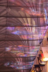
Stained glass light rainbows across earthquake netting in National Cathedral, September 13, 2012: Fortunately stained glass windows were not damaged, but netting was installed as precaution during thorough inspection.
Netting to be removed over a period of 20 months beginning in February, 2014.
nave vault's flags of all U.S. states, National Cathedral, Washington DC; National Register of Historic Places (NRHP) No. 74002170: Tim Evanson, CC BY SA 2.0, via Flickr @ https://www.flickr.com/photos/23165290@N00/8028503908/


 No. 05000271")
 No. 05000271")


")

")
, Fig. 60, p. 378")
 No. 82004560")


 northeast of epicenter")
")

 No. 05000271")
 No. 74002170")


 Mailing Addresses for 2025 Form 4868 Extending 1040 and 1040SR April 15, 2026, Due Dateon 04/02/2026
 Mailing Addresses for 2025 Forms 1040 and 1040SR Filed in 2026on 03/31/2026
 Are Hawaiian Huakai Po Nightmarchers Avenging Halloween Thursday?on 10/02/2024
 Mailing Addresses for 2023 Form 4868 Extending 1040 and 1040SR April 15, 2024, Due Dateon 04/15/2024


Comments
frankbeswick, Those earthquakes in the high 5 end of the scale definitely are noticeable.
That's an interesting question that you pose about a connection with collapsing old mine shafts because the Mineral area had a mining heyday.
Also interesting is that of the two main earthquake areas in Virginia -- central Piedmont region (scene of Mineral earthquake) and southwestern sector (Valley and Ridge region) -- the latter (where the Giles County earthquake occurred in 1897) abounds in karst landscape.
Excellent and informative article. I have only experienced a few quakes, the worst being two on the Richter scale, so I cannot but imagine what a 5.9 feels like. Do you think some of the tremors were augmented by old mine shafts collapsing? This is what caused an earthquake cluster in Manchester in the early years of this century. The scale 2 was the worst, but there were several scale 1 quakes; and it is no coincidence that the city contains many old mine shafts dating as far back as the industrial revolution.