Among shapes tackled in "How the States Got Their Shapes" is the urban myth that attributes Boston's winding streets to colonial cow paths.
"Cow Paths"; fiberglass cow by E.G. (Gayle Shanley) Fitzsimmons of Russell, Massachusetts, for CowParade 2006. The international art event was inaugurated in Chicago in 1999; Boston was one of participating cities in CowParade 2006.
Plaza III Kansas City Steakhouse, Faneuil Hall Marketplace, 1 S. Market St., Government Center; Thursday, Aug. 10, 2006, 15:44:33: Cirofono, CC BY 2.0, via Flickr @ https://www.flickr.com/photos/ciroduran/212274014/
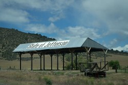
"How the States Got Their Shapes" presents historical stately possibilities -- such as Adelsverein in Texas, Deseret in the southwest, and Forgottonia in Illinois -- as well as modern stately movements, such as the State of Jefferson.
Since 1941, counties in northern California and southern Oregon have sought statehood as the State of Jefferson, with Yreka as provisional capital.
a barn near Yreka, central Siskiyou County, northernmost California; Sunday, May 26, 2013, 12:22: Visitor7, CC BY SA 3.0, via Wikimedia Commons @ https://commons.wikimedia.org/wiki/File:State_of_Jefferson_Barn.jpg
Texas Interconnection, managed by Electric Reliability Council of Texas (ERCOT), powers most of Texas as a separate power grid.
SPP (Southwest Power Pool) services uncovered parts of northwestern Texas. SERC (Southeastern Electric Reliability Council) and SPP are responsible for uncovered parts of eastern Texas.
The ERCOT grid encompasses approximately 75 percent of the land mass of Texas, according to ERCOT's website.: Claude (Bouchecl), CC BY SA 3.0, via Wikimedia Commons @ https://commons.wikimedia.org/wiki/File:NERC-map-en.svg
"How The States Got Their Shapes" (1:40) ~ Trailer
Uploaded January 10, 2012, by goentertain to YouTube ~ URL: https://www.youtube.com/watch?v=AzLPElmEAkE
Generally viewed as a tongue-in-cheek separatist movement, the Conch Republic encompasses Florida Keys and attracts tourists through annual weeklong Independence Day festivities on April 23; Office of Secretary General issues souvenir passports.
Conch Republic, nicknamed "A Sovereign State of Mind," was coaxed into existence on April 23, 1982, in response to US Border Patrol blockage of Florida Keys.
Office of Secretary General of Conch Republic, Key West, Florida: Steven Miller (Sam Howzit), CC BY 2.0, via Flickr @ https://www.flickr.com/photos/aloha75/6707838905/


 Mailing Addresses for 2025 Form 4868 Extending 1040 and 1040SR April 15, 2026, Due Dateon 04/02/2026
 Mailing Addresses for 2025 Forms 1040 and 1040SR Filed in 2026on 03/31/2026
 Are Hawaiian Huakai Po Nightmarchers Avenging Halloween Thursday?on 10/02/2024
 Mailing Addresses for 2023 Form 4868 Extending 1040 and 1040SR April 15, 2024, Due Dateon 04/15/2024


Comments
Thank you for coming over and liking this fascinating documentary film.
May you have the fortunate chance to watch the Stein/Unger collaboration. The images, information and narration merit the (not too long) wait.
The state shape-makers seem to have tried not to let any state get too big. For instance, they separated Carolina into North and South and Dakota into North and South.
So, without suggesting anything about something that obviously works for them being big states, I wonder why California and Texas weren't separated into North and South California and North and South Texas!
The history involved in shaping the States sounds exciting. Hopefully it did not contain disputes and rallies. It might not be available on Indian channels but if I ever get a chance to see it on TV serials, I will try not to miss.
CruiseReady, The book and the DVD work together very, very nicely for great learning fun that can be enjoyed over and over again!
Oh, this is something I really must see! it sounds like just the type of thing I would enjoy, and so much more worthwhile than yet another episode of the Big Bang Theory
Mira, I believe that the series is so highly regarded that it runs conveniently often on cable. It's worth the watch since the information is so interesting and so well presented, in both the book and the DVD!
blackspanielgallery, It's among my favorite programs because of Brian's intelligent charisma, the fun quizzes, and the great images and interactions with interviewees!
Mira, Brian Unger brings the engaging, informed perspective of a Romanian-American from Ohio transplanted to California while Mark Stein has that of a German-American from Maryland whose career involves writing books and scripts (including Housesitter with Goldie Hawn and Steve Martin).
It's great learning fun to have both the audio-visual and the text since the DVD arranges material thematically (for example, geography-, mining-, transportation influenced borders) whereas the book organizes information by alphabetically ordered states. So when Brian is talking about weird borders (such as Maine and Nevada), it's easy to find the state information in Mark's book and vice versa.
It is an interesting program. I have seen many episodes.
I see Season 1 is $21. Rather expensive, but so are most TV series. I'll try to catch it on cable.
This sounds very interesting!:)