Nuclear Power Plants in Virginia: Safer Than Washington DC During Recent Nearby Earthquake in 2011

by DerdriuMarriner

As proof of structural integrity, Virginia's two nuclear power plants were unshakable, despite epicenter proximity to one of them, during surprise earthquake in 2011.

The Commonwealth of Virginia included nuclear energy in its power portfolio over four decades ago. Both of its nuclear power plants are sited in the state's eastern sector.

When the state shook on Tuesday, August 23, 2011, from an earthquake that generated surprise locally, nationally, and internationally, the two power plants were unshakable, despite:
• epicenter proximity, at a distance of less than 10 miles (16 kilometers), to the North Anna Power Station, and
• placement of North Anna Power Station within top ten ranking in Nuclear Regulatory Commision (NRC)-generated study of susceptibility to core damage from earthquake.

In contrast, the Washington Monument and the National Cathedral in the U.S. capital, Washington, DC, located at a distance of over 80 miles (128.7 kilometers) northeast of the epicenter in Mineral, suffered noteworthy structural damages.

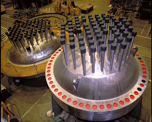
pressurized water reactor vessel heads

In their design as pressurized water reactors (PWRs), both of Virginia's nuclear power plants conform with the large majority of Western nuclear-powered plants.
rod travel housing and two lifting lugs on reactor vessel's removable head

Surry Power Station: first nuclear reactors in Virginia


The first two nuclear reactors in Virginia were installed on the south bank of the James River in Surry County. One of the oldest English settlement regions in the Commonwealth, Surry County was established in 1652. Located on Virginia's coastal plain, Surry County conveniently is placed midway between the cosmopolitan giants of Richmond and Virginia Beach.

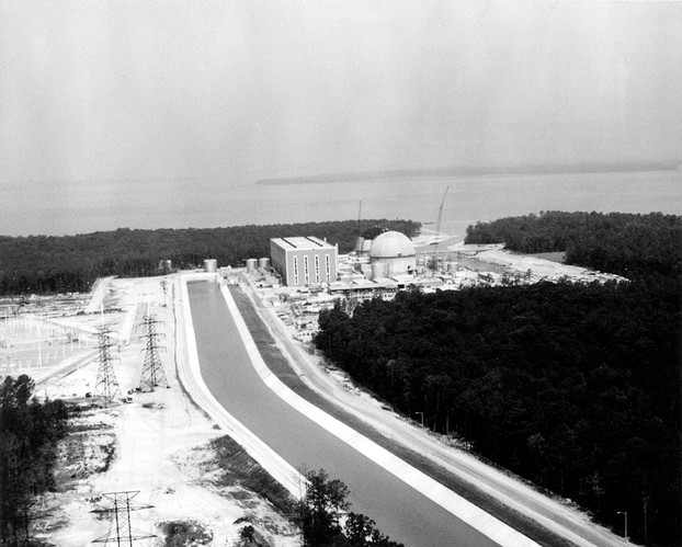
  • About 13 miles (21 kilometers) to the east of the county seat in the town of Surry, Virginia's first nuclear power plant sits on 840 acres (3.4 square kilometers) near the tip of Hog Island, a peninsula that juts into the Lower James River.


Surry Power Station is located 17 miles northwest of Newport News in Region II.

Surry Power Station lacks iconic cooling towers because of abundant water from James River's horseshoe around the peninsula.
Nov. 14, 2013, northwestward view of Surry Power Station, with Jamestown Island across James River


Surry Power Plant has prestigious neighbors. Diagonally across the James River is Historic Jamestowne. Established on Jamestown Island on May 14, 1607, Historic Jamestowne was situated strategically about 50 miles (96 kilometers) from the mouth of the bountiful Chesapeake Bay. The discovery and settlement of this idyllic location were funded by a group of London entrepreneurs whose charter as the Virginia Company was approved on April 10, 1606, by King James I (June 19, 1566 - March 27, 1625). For over four centuries, this first permanent English settlement in the New World has continued to beguile visitors with its historic remnants and paradisical landscape.


Statue of Captain John Smith (ca. January 1580 - June 21, 1631), Jamestown Colony, overlooks James River.

National Park Service-Colonial National Historic Park


Adjacent to Surry Power Plant, at the peninsula's tip, Hog Island Tract -- resplendent with tidal marshes and controlled ponds, amidst flat, open land of near sea level elevation and pine forests  --  is the northernmost segment of Hog Island Wildlife Management Area (HIWMA). Designated as a state wildlife management area on November 15, 1950, HIWMA comprises 3,908 acres (15.82 square kilometers), distributed over three disjunct, or separate, tracts. The Hog Island and Carlisle tracts lie within Surry County. The Stewart Tract is located in Isle of Wight County.

Southeast of the generating station are the protected area's two other tracts.

  • Carlisle Tract lies upland, at an elevation of about 35 feet (10.6 meters), with timbered areas reforested with loblolly pine (Pinus taeda). There also wildlife food and cover crops are planted along power line rights-of-way.
  • Across Lawnes Creek in Isle of Wight County is the Stewart Tract, which shares 50 acres (0.2 square kilometers) of marshland with the Carlisle Tract.

The first Westinghouse pressurized water reactor, Unit 1, went online at Surry Power Station in December 1972. Unit 2 was activated in May 1973.

Surry Power Station is owned by Dominion Resources, Inc. The station is managed by Dominion Generation, one of the owner corporation's three operating businesses.

Surry Power Station lies over 120 miles (193 kilometers) southeast of Virginia's second generating station on Lake Anna.


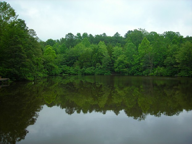
Lake Anna State Park: former site of Goodwin Gold Mine, where gold was discovered in 1829; mining peaked in 1880s; park opened in 1983, built around Lake Anna, created in 1971 as water coolant for power stations.

from gold mining to recreation and nuclear power

North Anna Nuclear Generating Station: Virginia's second power station


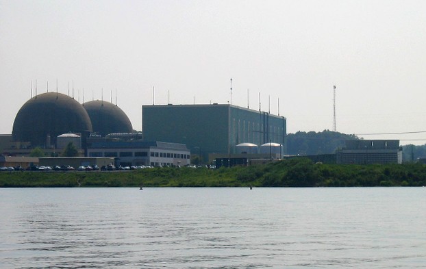
Formed by a dam on the southeasterly flowing North Anna River to serve as a water coolant reservoir for the power plant, Lake Anna stretches for 17 miles (27 kilometers) in length, with a panoramic shoreline of over 200 miles (322 kilometers). Covering an area of 13,000 acres (53 square kilometers), Lake Anna straddles Louisa, Spotsylvania, and Orange counties. In addition to cooling the power plant, Lake Anna is also a popular recreational destination, especially since the opening of Lake Anna State Park in 1983.

The two units provide power to northern Virginia and to the greater Richmond area.

  • The first Westinghouse pressurized water reactor was activated on Lake Anna on Tuesday, June 6, 1978, followed by the second reactor on Sunday, December 14, 1980.

North Anna Nuclear Generating Station is jointly owned by Dominion Virginia Power Corporation, headquartered in Virginia's capital, Richmond, and Old Dominion Electric Cooperative (ODEC), headquartered in Glen Allen, now a Richmond suburb. North Anna is operated by Dominion Resources Inc., a power and energy company headquartered in Richmond.

  • Since 2003, Dominion has been undergoing the lengthy application process for permission to add another unit at the North Anna site. The station's current generation of 1,892 megawatts equates to providing enough electricity to power 450,000 homes. The proposed unit would add 1,470 net megawatts. Dominion has indicated that the decision to build, or not, will not be made until after receipt of construction permit, which is slated for 2015.


Nuclear Regulatory Commission report: high risk rank for North Anna reactors


In August 2010, the Nuclear Regulatory Commission (NRC) released a report that ranked the 104 commercial reactors that are licensed for operation at 65 nuclear power plants in the continental United States. The report was the result of a study conducted for five years and three months by NRC staff in conjunction with an independent, non-profit contractor, Electric Power Research Institute (EPRI), headquartered in technologically and scientifically savvy Palo Alto, California. Derived from risk estimates based on 2008 and 1989 geological data, NRC's seismic task force rated each reactor according to susceptibility to core damage from an earthquake, based on U.S. Geological Survey (USGS) data. The reactors were listed from highest risk at number 1 to lowest risk at 104.

The report placed both units of the North Anna Generating Station in the top 10 percent, at 10a and 10b, as most at risk. The risk estimate displayed a 38 percent increase for both reactors at North Anna Power Generating Station. The previous estimate, calculated from 1989 data, established a likelihood of 1 in 31,250. The new estimate, based on 2008 data, expressed the yearly chance at 1 in 22,727.


NRC ranking: nuclear reactors at highest risk


Reactor                               New Estimate          Old Estimate          Change in Risk

Indian Point #3                     1 in 10,000                1 in 17,241                         72%

   Buchanan, New York

Pilgrim #1                             1 in 14,493                1 in 125,000                      763%

   Plymouth, Massachusetts

Limerick #1                           1 in 18,868               1 in 45,455                         141%

   Limerick, Pennsylvania

Limerick #2                           1 in 18,868                1 in 45,455                        141%

   Limerick, Pennsylvania

Sequoyah #1                        1 in 19,608                1 in 102,041                      420%

   Soddy-Daisy, Tennessee

Sequoyah #2                        1 in 19,608                1 in 102,041                      420%

   Soddy-Daisy, Tennessee

Beaver Valley #1                   1 in 20,833               1 in 76,923                         269%

   Shippingport, Pennsylvania

Saint Lucie #1                       1 in 21,739                       N/A                           N/A (activated      

   Jensen Beach, Florida                                                                                 March 1, 1976)

Saint Lucie #2                       1 in 21,739                       N/A                           N/A (activated

   Jensen Beach, Florida                                                                                 June 10, 1983)

North Anna #1                       1 in 22,727               1 in 31,250                         38%

   Louisa, Virginia

North Anna #2                       1 in 31,250               1 in 31,250                         38%

   Louisa, Virginia


NRC report: low risk for Surry reactors


On the other hand, both reactors at Surry Power Station were ranked in the bottom 20 percent, at 83a and 83b, as least at risk. With an old estimate of 1 in 175,439 balanced by a new estimate of 1 in 123,457, Surry reactors exhibited a great decrease in risk of minus 30 percent.


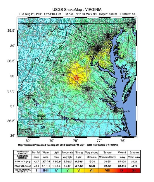
US Geological ShakeMap for Mineral, Virginia, earthquake on August 23, 2011

automatic computer-generated ShakeMap, version not checked by human oversight; red star indicates epicenter

Virginia's North Anna Power Station and the commonwealth's 5.8 magnitude earthquake on Tuesday, August 23, 2011


On Tuesday, August 23, 2011, the world learned what residents of Old Dominion have long known: The Commonwealth of Virginia has two main earthquake zones.

At 1:51:04 p.m. Eastern Daylight time (17:51:04 UTC) on a sunny Tuesday, an earthquake, centered in the town of Mineral, in Virginia's Piedmont region, sent tremors as far north as southeastern Canada. Originally categorized at a magnitude of 5.9, the earthquake subsequently was downgraded to 5.8 in magnitude.

Located less than 10 miles (16 kilometers) from the epicenter, North Anna Power Station detected vibrations via multiple reactor sensors. Its twin reactors automatically shut down.

  • The shutdown constituted the first earthquake-generated stoppage of a nuclear unit in the United States.

After conducting exhaustive analyses, inspections, and testing for over two months, at a cost of $21 million, Dominion determined that no functional damage had ensued from the earthquake. After completing an independent inspection of the station, the Nuclear Regulatory Commission confirmed Dominion's findings. In a letter dated Friday, November 11, 2011, the NRC authorized restarting the station.


Tale of two spires of National Cathedral: intact spire (right), dislodged but remained on roof; broken spire (left). Both are stored on ground for safety until re-installation.

Repairs of $20 million may take 10 or more years, depending on funding.
Thursday, December 29, 2011; Washington, D.C.

Conclusion: Safer to be at North Anna Power Station, near an earthquake's epicenter, than 80 miles away in Washington D.C.?


Despite an adversely high ranking as a high-risk candidate for core damage from an earthquake, Virginia's North Anna Power Station performed admirably as a safe site during the 5.8 magnitude tremor that shook the Commonwealth in the early afternoon of a sunny Tuesday late in August, 2011. Reactors shut down automatically, resulting in the first earthquake-generated shutdown of a nuclear facility in the United States.

Reassuringly, extensive reviews by Dominion, the station's owners, revealed no functional damage. The Nuclear Regulatory Commission confirmed the company's findings.

After four decades of nuclear power-generated electricity, the Commonwealth of Virginia places a notch above midway in the ranking of nuclear-generated kilowatts of electric power consumed by the 31 states using nuclear power.

The industry appears to be steering a safe path in its participation in Virginia's electricity needs.


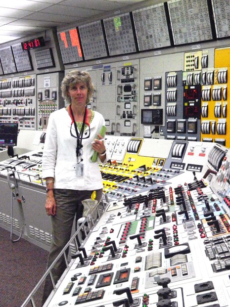
NRC Chairman Allison Macfarlane: inside control room of North Anna nuclear power plant during her tour on Monday, August 6, 2012

Louisa County, north central Virginia

Acknowledgment


My special thanks to talented artists and photographers/concerned organizations who make their fine images available on the internet.


Image Credits


pressurized water reactor vessel heads
In their design as pressurized water reactors (PWRs), both of Virginia's nuclear power plants conform with the large majority of Western nuclear-powered plants.
rod travel housing and two lifting lugs on reactor vessel's removable head: Nuclear Regulatory Commission (NRCgov), Public Domain, via Wikimedia Commons @ https://en.wikipedia.org/wiki/File:Reactor_Vessel_head.jpg

Surry Power Station is located 17 miles northwest of Newport News in Region II.
Surry Power Station lacks iconic cooling towers because of abundant water from James River's horseshoe around the peninsula.
Nov. 14, 2013, northwestward view of Surry Power Station, with Jamestown Island across James River: Public Domain, via Wikimedia Commons @ https://commons.wikimedia.org/wiki/File:HD.6D.369_(10856484283).jpg/

Statue of Captain John Smith (ca. January 1580 - June 21, 1631), Jamestown Colony, overlooks James River.
National Park Service-Colonial National Historic Park: Public Domain, via Wikimedia Commons @ https://en.wikipedia.org/wiki/File:Historic_Jamestowne.jpg; Public Domain, via U.S. Department of Transportation Federal Highway Administration @ https://www.fhwa.dot.gov/byways/photos/60524

Lake Anna State Park: former site of Goodwin Gold Mine, where gold was discovered in 1829; mining peaked in 1880s; park opened in 1983, built around Lake Anna, created in 1971 as water coolant for power stations.
from gold mining to recreation and nuclear power: Brent Hoard (phi1317), CC BY 2.0, via Flickr @ https://www.flickr.com/photos/bhoard/2643538235/

North Anna Power Station: view across Lake Anna reservoir
Louisa County, Virginia: dougward from Devon, United States, CC BY SA 2.0, via Wikimedia Commons @ https://commons.wikimedia.org/wiki/File:North_Anna_NPP_retouched.jpg

US Geological Shake Map for Mineral, Virginia, earthquake on August 23, 2011
automatic computer-generated ShakeMap, version not checked by human oversight; red star indicates epicenter: U.S. Geological Survey, Public Domain, via Wikimedia Commons @ https://commons.wikimedia.org/wiki/File:Virginia_earthquake,_Aug_23.jpg

Tale of two spires of National Cathedral: intact spire (right), dislodged but remained on roof; broken spire (left). Both are stored on ground for safety until re-installation.
Repairs of $20 million may take 10 or more years, depending on funding.
Thursday, December 29, 2011; Washington, D.C.: Tim Evanson, CC BY SA 2.0, via Flickr @ https://www.flickr.com/photos/23165290@N00/6623005507/

NRC Chairman Allison Macfarlane: inside control room of North Anna nuclear power plant during her tour on Monday, August 6, 2012
Louisa County, north central Virginia: Nuclear Regulatory Commission (NRCgov), CC BY 2.0, via Flickr @ https://www.flickr.com/photos/nrcgov/7753157282/

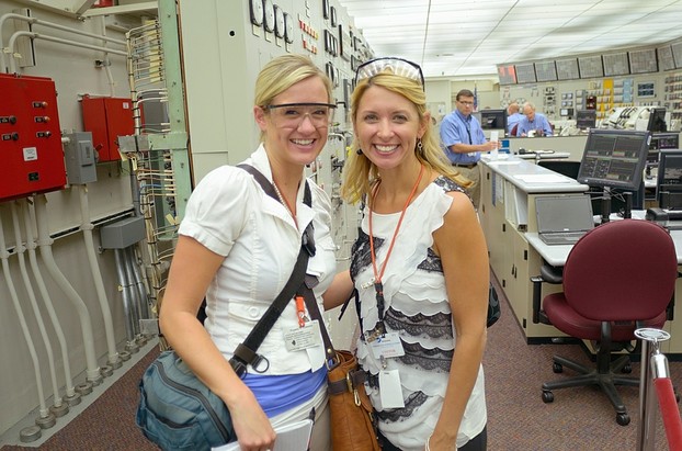
Wednesday, August 15, 2012: Broadcast journalists Katelyn Sherwood of Richmond's 8News and Tracy Sears Harvey of Richmond's WTVR CBS 6 in North Anna's control room
The reporters toured the facility's high-tech simulator, which simulated the conditions of the 2011 Mineral earthquake.
photo by CBS 6 photographer Jack Rusak: tvnewsbadge, CC BY 2.0, via Flickr @ https://www.flickr.com/photos/tvnewsbadge/7792101020/

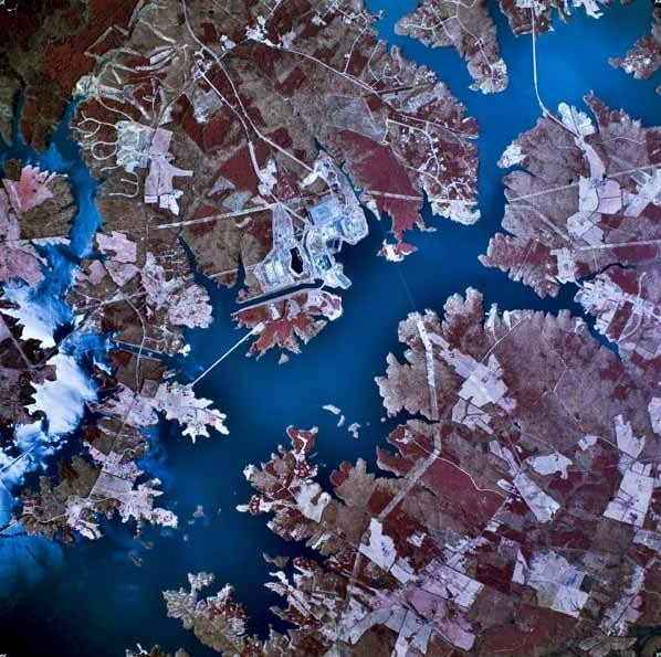
left center: North Anna Nuclear Generating Station
Lake Anna, Louisa and Spotsylvania counties, north central Virginia: Public Domain, via Wikimedia Commons @ https://en.wikipedia.org/wiki/File:LakeAnnaAerial.JPG


Wednesday, August 15, 2012: Broadcast journalists Katelyn Sherwood of Richmond's 8News and Tracy Sears Harvey of Richmond's WTVR CBS 6 in North Anna's control room

The reporters toured the facility's high-tech simulator, which simulated the conditions of the 2011 Mineral earthquake.
photo by CBS 6 photographer Jack Rusak

Sources Consulted


Dominion Virginia Power Begins Restart of North Anna Power Station.” Dominion Corporate > News Releases. November 11, 2011. Dominion. Web. www.dom.com. Retrieved September 13, 2014.

  • Available at: http://dom.mediaroom.com/index.php?s=26677&item=84065

Ferguson, Charles D. Nuclear Energy: What Everyone Needs to Know®. New York: Oxford University Press, 2011.

Johnsson, Julie, and Brian Wingfield. “U.S. Nuclear Industry Tested by Twin Threats From Nature.” Bloomberg Businessweek > Bloomberg News. August 24, 2011. Bloomberg L.P. Web. www.businessweek.com. Retrieved September 13, 2014.

  • Available at: http://www.businessweek.com/news/2011-08-24/u-s-nuclear-industry-tested-by-twin-threats-from-nature.html

"North Anna Power Station, Unit 1." U.S. Nuclear Regulatory Commission > Operating Nuclear Power Reactors. Page Last Reviewed/Updated Wednesday, April 23, 2014. U.S. Nuclear Regulatory Commission. Web. www.nrc.gov. Retrieved September 13, 2014.

  • Available at: http://www.nrc.gov/info-finder/reactor/na1.html

"North Anna Power Station, Unit 2." U.S. Nuclear Regulatory Commission > Operating Nuclear Power Reactors. Page Last Reviewed/Updated Wednesday, April 23, 2014. U.S. Nuclear Regulatory Commission. Web. www.nrc.gov. Retrieved September 13, 2014.

  • Available at: http://www.nrc.gov/info-finder/reactor/na2.html

“North Anna Power Station Unit 3.” Dominion Corporate > About > Stations > Nuclear > North Anna. Dominion. Web. www.dom.com. Retrieved September 13, 2014.

  • Available at: https://www.dom.com/about/stations/nuclear/north-anna/north-anna-3.jsp

"Nuclear Power in Virginia." Virginia Places > The People and Development of Virginia > Energy > Nuclear Power. Charles A. Grymes. Web. www.virginiaplaces.org. Retrieved September 13, 2014.

  • Available at: http://www.virginiaplaces.org/energy/nuclearpower.html

"Surry Power Station, Unit 1." U.S. Nuclear Regulatory Commission > Operating Nuclear Power Reactors. Last Reviewed/Updated Wednesday, February 26, 2014. U.S. Nuclear Regulatory Commission. Web. www.nrc.gov. Retrieved September 13, 2014.

  • Available at: http://www.nrc.gov/info-finder/reactor/sur1.html

"Surry Power Station, Unit 2." U.S. Nuclear Regulatory Commission > Operating Nuclear Power Reactors. Last Reviewed/Updated Wednesday, February 26, 2014. U.S. Nuclear Regulatory Commission. Web. www.nrc.gov. Retrieved September 13, 2014.

  • Available at: http://www.nrc.gov/info-finder/reactor/sur2.html


left center: North Anna Nuclear Generating Station

Lake Anna, Louisa and Spotsylvania Counties, north central Virginia
the end which is also the beginning

Nuclear Energy: What Everyone Needs to Know® by Charles D. Ferguson ~ Available via Amazon

In this accessible overview, Charles D. Ferguson provides an authoritative account of the key facts about nuclear energy.
nuclear power-themed books

Garfield - Use Alternative Energy Sources: cream t-shirt ~ Available via Amazon

alternative energy sources-themed t-shirt

Me and my purrfectly purrfect Maine coon kittycat, Augusta "Gusty" Sunshine

Gusty and I thank you for reading this article and hope that our product selection interests you; Gusty Gus receives favorite treats from my commissions.
DerdriuMarriner, All Rights Reserved
Updated: 01/04/2025, DerdriuMarriner
 
Thank you! Would you like to post a comment now?
5

Comments

Only logged-in users are allowed to comment. Login

You might also like

Norah's Cafe in Taubman Museum of Art: A Great Cup of Coffee O...

Norah's Café began serving cold and hot drinks and homemade dishes with Taubm...

Tackling Hunger: Plant A Row for the Hungry and USFWS Chesapea...

Committed to tackling hunger, US federal government employees make a differen...


Disclosure: This page generates income for authors based on affiliate relationships with our partners, including Amazon, Google and others.
Loading ...
Error!