The Wild Atlantic Way

by frankbeswick

Ireland's Wild Atlantic Way is a long route along a spectacular coast with impressive views of the sea

For an island of only thirty two thousand square miles Ireland's Wild Atlantic Way is a long route, as it weaves in and out along estuaries and bays. It is not a short route and only marathon walkers will have done the whole lot in one journey, but it can be done either on foot [ideally] or by car, which takes you further and faster, though you miss the little footpaths [boreens] that bring you close to the land. I have not done it all, though I have walked or driven on large sections of it, and this article will give a small taste of what is there.

Photo courtesy of hbiese

An overview

Sli an Atlantaigh Fhian [Slee 'n Atlantic Feen] takes the coastal route from Donegal in the North down to Cork in the South West, and journeying it this way you have the rising sun on your left and the rolling Atlantic waves on your right as you stride or maybe amble along paths that are sometimes high on cliffs and at others close to the shore. To your left is the green terrain of Ireland and your right  the coast, in whose waters there is a scattering of islands, such as Achil, where I once camped on the greensward one cold February night some years ago, too long ago for my liking, but not long enough to forget, as if it will ever be forgotten. 

There are nine counties en route. The northern stretch takes you south from mountainous Donegal and the mighty cliffs of Slieve League through a small section of Leitrim, a county that I know well, through Sligo. The Western section leads you through Mayo, whose impressive coast includes Killary Harbour, a small but perfectly formed fjord, and the island-studded Clew Bay. The Mid West section includes Clare and Limerick and the Shannon Estuary, where the longest river in the British Isles meets the ocean. It is in this section that the route passes along the mighty cliffs of Moher, limestone buttresses that stand like giant sentinels against the incessant pounding of the Atlantic. Finally, the southern section concludes by passing through Kerry, Ireland's most south westerly county, whose deeply indented bays provide a rich variety of scenery, and then through Cork, through the rugged land of Beara. On the way you might visit Dursey Island, an inhabited isle accessible by Ireland's only cable car, or take a boat trip to the now deserted Blaskett Islands, on whose largest isle, Great Blaskett, The Island Man the famous book  that told of the islanders' lives, was written. 

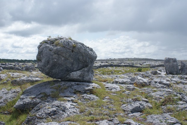
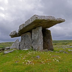
My first encounter with the route was when a group of us travelled down via Mayo and Galway, finally camping on the desolate south shores of Galway Bay west of Ballyvaughan. We found a small unused patch of land to pitch the tent and settled for the evening. But I found time to ascend the slopes to the limestone plateau of the Burren and surveyed the landscape of fissured limestone. Walking inland and soaking in the silence I came upon a boulder, which marked the termination of my route, and as the sun was setting over Galway Bay I needed to be safe in the tent  when it was dark. But I  experienced a wild land with a stark beauty that has remained with me as a memory since then.  

Next morning I walked down to the shore, but a word of warning, the south shore of Galway Bay where I camped is not safe for swimming and there were warning notices at several places.

The Burren

The Burren
The Burren
Body-n-Care

Some Lovely Bays

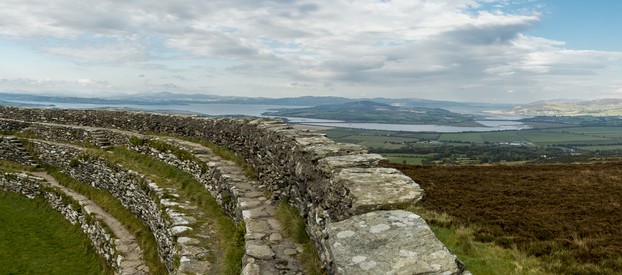
"With a bit of land at Lough Swilly and a fishing rod you wouldn't need a job." said one of my Northern Irish  in-laws dreamily. Well,that's an exaggeration, but it spoke to my self-reliant instincts. This beautiful lough goes deep inland, and on its eastern sides is the quiet Inishowen Peninsula, whereas on the western side there are the rugged hills of Donegal.  Maureen and I  drove from our holiday cottage at Rathmilton up fo Fannad Head and stood on the foreland that juts into the Atlantic, which that day was tranquil, but we were not deceived that this was anything but a slumbering Leviathan waiting to pounce. 

Further south there are some scenic bays. Clew Bay in   Mayo is studded with small islands, the products of dumping by a glacier. No one lives on them, as they are uninhabitable, for they are too small, exposed and lack fresh water, but they make a great view from Croagh Patrick, Ireland's holy mountain,on whose stony exposed and misty summit summit St Patrick was said to have spent his lenten fast. John Lennon let a group of hippies dwell on one island there that he owned, but they only lasted the summer before the Atlantic storms forced their evacuation. There was, they realized, a reason why the local Irish did not inhabit the islands.

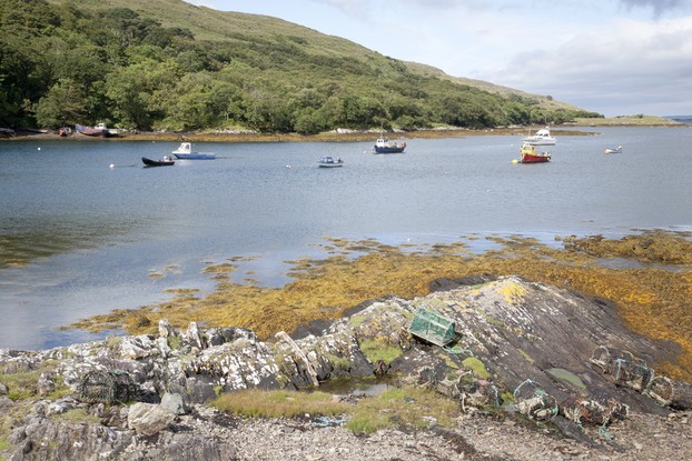
Not far away is Killary Harbour, a small, but perfectly formed fjord jutting into the ancient and stark mountains of  Connemara, one of Ireland's wildest places. It is a natural harbour and was where the French fleet landed on its ill-fated expedition to support the Irish rebels in the 1798 rising. Killary is worth seeing. 

South of this is Galway Bay at whose head is the town of Galway, a  settlement worth a visit. At times I have stood on the north shore and enjoyed a warm, moist and gentle south westerly blowing up from more southerly climes, a delightful experience. Take time to see Lough Corrib, the large lake that drains steeply through the fast flowing river Corrib, into the bay. It is worth taking a boat trip.There are in the lough, my sister once noted, some very large eels. 

Towards the south the bays of Kerry a narrow and long. They are not fjords like Killary, but rias, drowned, unglaciated estuaries, created when valleys deepened after the Ice  Age by running water were flooded by rising seas. Dingle Bay is my favourite, and it is quite shallow except for the narrow channel in the middle, which is deep enough to allow small vessels to pass. But the bays are windy. Once when walking at the head of the bay in a wind from the sea I had my head down and suddenly became aware of a presence behind me. On looking round I found that I had strayed into  the middle of the road and a friendly  police man had placed his car behind me. He told me that the wind had been steadily pushing me towards the middle of the road and that,having seen what was happening,  he had come up at my rear for my protection. This was a common problem with tourists who do not know the area, he explained. I thanked him and took more care afterwards. 

Lough Swilly from the Grianan of Aileach

Lough Swilly from a distance
mtnmichelle

Killary Fjord

Killary Fjord
Killary Fjord
Kevers

Hills

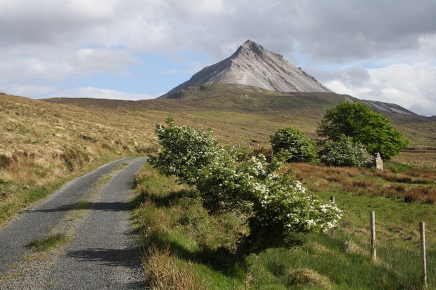
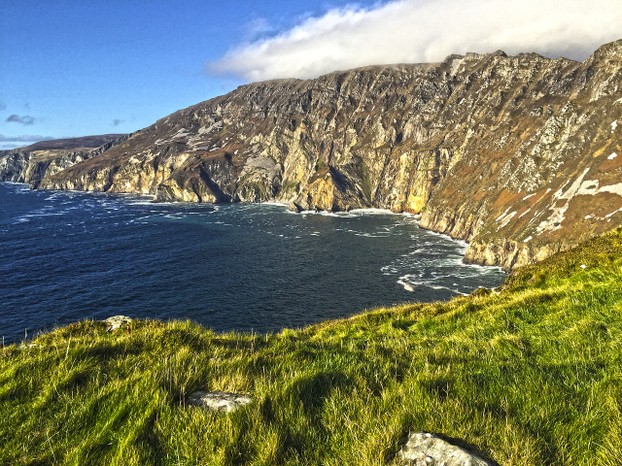
While the British Isles have no large mountains, there are some small and rugged ones in both islands.When I first saw Errigal in Donegal from a distance I was impressed with its stark, rocky beauty as it stood out for its shape among the surrounding hills. It is not the largest mountain in Ireland, being just above 2000 feet, but it is a mountain with character whose stony slopes make for some interesting ascending. Donegal also posseses the great coastal cliffs of Slieve League [see the picture below] along which the Wild Atlantic Way passes. For the ancient Irish the Western ocean was the gateway to the other world, and when you see the sun sinking into the distant west you see why they thought and felt thus.

There are some rugged hills in the Western parts of Ireland. As your journey takes you south from Donegal you go through Sligo, where you might pass Ben Bulben, an ancient and massive limestone coral reef made famous by Yeats' epitaph where he described his tomb as lying under bare Ben Bulben's back in Drumcliffe churchyard. Further south from here you pass the Ox Mountains on the east. I passed through them one late winter, stopping at the lonely Lough Talt where we sat for a while and took in the view.

Thence the southward route takes you through the small and difficult mountains of the West, first the mountains of West Mayo, quartzite blocks that make for difficult walking in wet conditions.  I remember once hiking in Mayo and seeing the mountains pale blue in a haze, and was smitten by the loveliness of the sight. Situated between Killary fjord and the Doulough Pass [Black Lake Pass] is the highest mountain in the province of Connaught, Mwllrea. This mountain is small, but difficult to ascend and you need to take care. Croagh Patrick is also difficult,as it contains masses of loose rocks that make ascending and descending difficult, yet many Irish folk piously ascend it one a year in bare feet. When Maureen did it last year she wore boots!.

South of the mountains of Mayo is Connemara. One of the best views of this land of ancient rock is as you walk up the coast from Galway, for at a certain point you get a glorious view of these hills, and you can do nought but stand in awe at their beauty. I got this view once on a clear day after rain and the hills stood out with clarity in the dust free air. 

Finally you come to Ireland's highest mountains, the mountains of Kerry, where Ireland's highest peaks are found. They make for some great walking. These hills march down to the deeply indented coast. I can recall ascending above Dingle Bay and finding a small estate off bungalows constructed above the ocean. Nice buildings, a great place in Summer, but I would be wary of living on a height above the Atlantic in Winter, but I suspect that they were holiday cottages. 

Errigal

Errigal
Errigal
Namastenomad

Slieve League

Slieve League
Slieve League
Asatira

Finale

There is a magic or enchantment in the West of Ireland and a journey down the coast brings it out.Much remains to be experienced, far more than I can cover in this article, but I have tried to give an overview or taster to whet your appetites for more of this enchanting land and seascape. There the continent confronts the ocean, and the remains of Ireland;s historic past stand as mute memorials to the passing of ages. It is a land with which I have fallen in love and which I love to visit when I can.  Enjoy your journeying along this coast.

Updated: 02/21/2018, frankbeswick
 
Thank you! Would you like to post a comment now?
21

Comments

Only logged-in users are allowed to comment. Login
frankbeswick on 10/26/2024

Yes. The Atlantic storms cause problems. My daughter dw Ellis on The island of Anglesey and sometimes in storms, which are often the tail end of an American hurricane,e The police close the bridges

DerdriuMarriner on 10/25/2024

Thank you for your comment below, on Jan. 12, 2024, in answer to my previous, previous-day observation and question.

High waves and winds particularly can be dangerous between Hawaiian islands.
Is such the case concerning Dursey?
If so, might that suspend cable-car schedules?

frankbeswick on 01/12/2024

Yes.

DerdriuMarriner on 01/11/2024

The second paragraph to the first subheading, An overview, considers Dursey Island as "accessible by Ireland's only cable car."

Does that mean that there's a cable running from the mainland to that island and that the cable car, attached only at the top, runs from mainland to island like a zipliner ziplines from one cliff to another over open water?

frankbeswick on 01/11/2024

Sorry,I do not know. I suspect that Achil might be the residue of an earlier non-Celtic language, possibly stretching back to Neolithic times. But which language I know not.

DerdriuMarriner on 01/10/2024

Online sources do not seem to be forthcoming regarding the meaning of achill even as they give its etymology as from the Irish Acaill and Oileán Aclan.

The Mayo Ireland Limited site identifies "look-out, prospect" as a possible meaning even as it indicates that "the idea sometimes advanced that it may be related to the Latin word aquila, 'an egale', seems groundless.”

Might you have access to the correct etymology?

DerdriuMarriner on 01/10/2024

Thank you!

Those are compelling reasons for your choice of Achill.

frankbeswick on 01/09/2024

We went in the expectation of finding somewhere to camp. It is quite easy to do so. The first night we camped on Black Head, County Clare, a barren limestone headland overlòking Galway Bay. That was cold. Then we headed for Achil, which made sense as part of the route back to college. I .did not know then how cold it would be.. We selected Achil because it offers camping sites near the beach and it has a bridge to the mainland.

DerdriuMarriner on 01/08/2024

The first paragraph to the first subheading, An overview, contains a succinct reminiscence of roughing-and-toughing-it camping on the island Achil.

Did you know what you were getting into, in the way of a cold, out-of-the-way, rough spot?

What made you select Achil over the other "scattering of islands"?

frankbeswick on 01/07/2024

You are probably, nay almost certainly right, in saying that six weeks is a minimum. There are plenty of hotels, guesthouses and camp sites en route.


You might also like

A Visit to the Giant's Causeway

The Giant's Causeway is a world heritage site well worth visiting

The Summer Isles: a book review

The Summer Isles,by Philip Marsden, makes an excellent and compelling read.


Disclosure: This page generates income for authors based on affiliate relationships with our partners, including Amazon, Google and others.
Loading ...
Error!