Henry S Reuss Ice Age Visitor Center near Dundee: headquarters of northern unit of Kettle Moraine State Forest: Royalbroil, CC BY-SA 2.5, via Wikimedia Commons @ https://en.wikipedia.org/wiki/File:ReussIceAgeVisitorCenter.jpg
Note winter pack ice's extension further south than now: Hannes Grobe-Alfred Wegener Institute Polar/Marine Research-Bremerhaven, CC BY-SA 2.5, via Wikimedia Commons @ https://commons.wikimedia.org/wiki/File:Northern_icesheet-fr.png
designated as Ramsar Site #511 on 4/12/90 for importance for nesting and international spring/fall flyway: Ryan Hagerty/US Fish and Wildlife Service, Public Domain, via USFWS Digital Library @ https://digitalmedia.fws.gov/digital/collection/natdiglib/id/8993
Chippewa Moraine State Recreation Area: The Cut, CC BY 2.0, via Flickr @ https://www.flickr.com/photos/63875512@N04/6612597909/
Devil's Lake and its soaring bluffs: Robin Davies (newlow), CC BY 2.0, via Flickr @ https://www.flickr.com/photos/newlow/2942736580/
7 Hills Road, Mount Calvary, east central Wisconsin, north of Henry S Reuss Ice Age Visitor Center: Royal Broil (royal_broil), CC BY-SA 2.0, via Flickr @ https://www.flickr.com/photos/royal_broil/2578823275/
kame's distinctive conical shape: Wisconsin Department of Natural Resources, CC BY ND 2.0, via Flickr @ http://www.flickr.com/photos/widnr/6587805463/
glacial kame hovering behind cornfield: Royal Broil (royal_broil), C BY-SA 2.0, via Flickr @ http://www.flickr.com/photos/royal_broil/8265044337/
a kettle, or pothole, lake in Eagle Oak Opening State Natural Area (No.66), Waukesha County, Kettle Moraine State Forest-Southern Unit: Joshua Mayer (wackybadger), CC BY SA 2.0, via Flickr @ http://www.flickr.com/photos/wackybadger/4580685854/
bouldered moraine along Ice Age National Scenic Trail, Devil's Lake: Wisconsin Dept of Natural Resources, CC BY-ND 2.0, via Flickr @ http://www.flickr.com/photos/widnr/6550537591/.
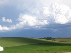
view from Lapham Peak Unit Lookout Tower: Wisconsin Dept Natural Resources, CC BY-ND 2.0, via Flickr @ http://www.flickr.com/photos/widnr/6582429393/
Spruce Lake Bog State Natural Area: Wisconsin Dept of Natural Resources, CC BY-ND 2.0, via Flickr @ http://www.flickr.com/photos/widnr/6583098929/
Pike Lake: Michael Pereckas (Beige Alert), CC BY 2.0, via Flickr @ https://www.flickr.com/photos/beigephotos/6067301819/
Old World Wisconsin, a popular historic attraction in Kettle Moraine State Forest's Southern Unit: Randen Pederson (chefranden), CC BY 2.0, via Wikimedia Commons @ https://commons.wikimedia.org/wiki/File:OldWorldWisconsinRaspberrySchoolHouse.jpg; originally via Flickr @ http://www.flickr.com/photos/48394718@N00/272791990
Oak Opening State Natural Area (No. 229), Kettle Moraine State Forest-Southern Unit: Wisconsin Department of Natural Resources, Public Domain, via NPS Ice Age National Scenic Trail @ http://www.nps.gov/media/photo/gallery.htm?id=696BF7AA-155D-4519-3EDAA2ADA723FC33
Congressman Henry S. Reuss wrote about trailing the ice age: US House of Representatives, Public Domain, via Wikimedia Commons @ http://en.wikipedia.org/wiki/File:Henry_S._Reuss.jpg
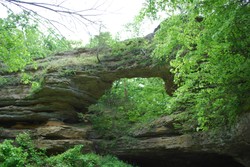
Dalles of the St. Croix River, Interstate State Park: 123dieinafire, Public Domain, via Wikimedia Commons @ https://en.wikipedia.org/wiki/File:Dalles_Of_St_Croix.jpg
Parnell Observation Tower: Royalbroil, CC BY-SA 2.5, via Wikimedia Commons @ https://en.wikipedia.org/wiki/File:ParnellTower2007.jpg
spectacular bird's eye views from Parnell Tower: Aaron Cantleberry, CC BY ND 2.0, via Flickr @ http://www.flickr.com/photos/aaroncantleberry/5766762920/
Kettle Moraine Scenic Drive, LaGrange, Walworth County, southeastern Wisconsin: Wisconsin Dept of Natural Resources, CC BY-ND 2.0, via Flickr @ http://www.flickr.com/photos/widnr/6582434171/
1838 oil on canvas by George Catlin (July 26, 1796-December 23, 1872): Smithsonian American Art Museum, Public Domain, via Wikimedia Commons @ https://en.wikipedia.org/wiki/File:Osceola.jpg
stand of paper birch (Betula papyreus), Milwaukee River Tamarack Lowlands and Dundee Kame State Natural Area (no. 256): Joshua Mayer (wackybadger), CC BY SA 2.0, via Flickr @ https://www.flickr.com/photos/wackybadger/4596896443/
kame in Kettle Moraine State Forest: Abloe428, Public Domain, via Wikibooks @ https://en.wikibooks.org/wiki/File:Kame.jpg
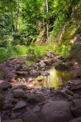
Butler Lake and Flynn's Spring State Natural Area (No. 257), Kettle Moraine State Forest Northern Unit: Joshua Mayer (wackybadger), CC BY-SA 2.0, via Flickr @ https://www.flickr.com/photos/wackybadger/5563306568/


, Waukesha County, Kettle Moraine State Forest-Southern Unit")


, Kettle Moraine State Forest-Southern Unit")


; Smithsonian American Art Museum")
, Milwaukee River Tamarack Lowlands and Dundee Kame State Natural Area (no. 256)")

, Kettle Moraine State Forest Northern Unit")


 Mailing Addresses for 2025 Form 4868 Extending 1040 and 1040SR April 15, 2026, Due Dateon 04/02/2026
 Mailing Addresses for 2025 Forms 1040 and 1040SR Filed in 2026on 03/31/2026
 Are Hawaiian Huakai Po Nightmarchers Avenging Halloween Thursday?on 10/02/2024
 Mailing Addresses for 2023 Form 4868 Extending 1040 and 1040SR April 15, 2024, Due Dateon 04/15/2024

Comments
The Wisconsin Department of Natural Resources (DNR) fits the Nebraskan glaciation with Nebraska state 300,000 to 260,000 years ago.
The DNR gives the best-preserved deposits and landforms as -- of course -- Nebraska even as it guides us to the Nebraska-neighborly, Nebraska-surrounding states.
So would that be all or some states from neighboring South Dakota, Iowa, Missouri, Kansas, Colorado, and Wyoming?
The Wisconsin Department of Natural Resources (DNR) equates the Kansan glaciation with Kansas state about 260,000 to 180,000 years ago.
It's interesting that Kansas state impels a terminal "s" even as Kansan iterates none!
What might manifest if we match each state with its adjectival mustering?
The Wisconsin Department of Natural Resources (DNR) describes the Illinoian glaciation as developing 230,000 to 130,000 years ago.
The DNR equates that glaciation with best-preserved deposits and landforms in the Wisconsinian neighbor Illinois!
Now what happened to the "s" in Illinoian even as Illinois hosts a terminal "s"!
The Wisconsin Department of Natural Resources (DNR) characterizes the most comprehensive landform and rock records as perhaps 75,000 to 11,000 years old.
What does the DNR designate as 75,000- to 11,000-year-old landform and rock records?
Such iconic Unitedstatesian-Midwestern features as the Great Lakes, drumlins!
For those asking about the names Wisconsin, Illinoian, Kansan, and Nebraskan glaciation in the paragraph between the second and third in-text images, the four names acknowledge the states where the most complete, the best-studied evidence of the particular ice advance abide.
So does the evidence deemed most developed and dazzling designate the states Wisconsin, Illinois, Kansas and Nebraska?
Yes!
And wouldn't that work as a wonderful bonus-point easy question on a geology exam or quiz?
For those asking about common- and proper-name etymologies, online sources analyze the surname Reuss through two general approaches.
One such concern considers proper names as caused by name-holder chores.
The German-language interpretation is iterated in terms of the last-name Reuss.
A German spelling suggests Rieß, said with the French, not the Spanish, r, as reess.
How would Rieß work as an English-language surname? Cobbler!.