Wisconsin's Natural Bridge State Park: Arch, Rockshelter, Shade-Tolerant Flora of Medicinal Interest

by DerdriuMarriner

Wisconsin's Natural Bridge State Park claims the Midwest's greatest natural arch and bridge and houses the region's oldest inhabited rockshelter, with natively vegetated trails.

Natural Bridge State Park: Unsupervised Visitors and Visits

Natural Bridge State Park can be visited year-round. Visiting hours commence at 6 a.m. and end at 8 p.m. Visitors have no interactions with law enforcement or park employees since Natural Bridge is unsupervised. Devil's Lake State Park staff nevertheless remain responsible for managing Natural Bridge.

Day passes or park stickers are required. An honor system lets visitors obtain passes from a self-registration booth. Visitors oftentimes use one pass for dayvisiting:
• Devil's Lake;
• Natural Bridge;
• Parfrey's Glen.

Visitors can bring their own food to enjoy at entryway tables. There is rustic public restroom access nearby. Insect repellents may be needed along the trails. Drinks, foods and pets may not leave the parking/picnicking area.

Natural Bridge's sites and trails are interesting to all ages. The walk nevertheless can challenge adults and children unused to field trip-like excursions. Visitors cannot count on rests as overnight campers. Overnight camping nevertheless is allowed just down the road at Devil's Lake.

Less than 20 miles (32k) northeast of Natural Bridge, Devil's Lake State Park offers an array of recreational activities amidst paradisical scenery.
view of northern shore of Devil's Lake
The Baraboo Range exemplifies a buried mountain range, exposed through erosion, colorful with mainly Baraboo quartzite and red rhyolite
Baraboo Range in winter
The bridge in fact links the northern vegetation-rich tract of birds and small mammals with the southern vegetation-rich tract of birds and mammals of larger and smaller sizes.
Natural Bridge State Park's natural bridge arches over rockshelter.

Natural Bridge State Park: the Story of an Arch and its Bridge


Wisconsin's Natural Bridge State Park can be accessed by Sauk County Highway C. The access can be from the north by Baraboo. Or it can be from the south by Sauk City. By either approach, the highway conducts visitors to an area between the unincorporated communities of Denzer and Leland. The town of Honey Creek fills the above-mentioned in-between area. It includes within its limits the 530-acre (214.48-hectare) tract that now bears the name Natural Bridge State Park.

Geography and geology account for the tract warranting the protective designation and status of state park. In terms of geography, the tract is located within the Baraboo Range. The range occupies the fringes of the Great Driftless Area in the midwestern United States of America.

The term driftless describes land which was not glaciated during the last Ice Age. It therefore introduces the impact of geological processes upon terrain. Specifically, glaciation leaves permanent marks upon the landscape from the frozen millennia of its duration and the scouring ravages of its spring thaws, soil percolation, and atmospheric evaporation.

A lack of glaciation allowed sandstone outcroppings to build up and jut out within the Driftless Area. A lack of scouring left the sandstone outcroppings intact and unbroken by rolling boulders and rushing waters. A lack of shelter beneath icy layers and of trauma during global thawing let these same outcrops respond gently to slow, steady erosive weathering by area rainfall and winds.

Water and wind erosion indeed are creators of the natural arch and bridge for which the tract claims more than 10,000 years of admiration from area humans. The bridge is 40 feet (12.19 meters) from the ground. Its underlying arch reaches a maximum height of 35 feet (10.67 meters) and width of 25 feet (7.62 meters).

The arch contains some of the oldest sandstone in the United States. The sandstone dates back 1.6 billion years to the Cambian era. The arch also holds a record as the largest natural manifestation of its kind in Wisconsin and the entire Midwest.

The arch appeals timelessly to human populations for two practical reasons in particular. One practicality concerns the availability of safe, secure, straightforward transportation across the overlying bridge. This role of the bridge in facilitating access between two similarly wildlife-abundant areas is historically important. The bridge in fact links the northern vegetation-rich tract of birds and small mammals with the southern vegetation-rich tract of birds and mammals of larger and smaller sizes.

The other practicality concerns the possibility of shelter from extreme temperatures and severe weather. Where natural processes leave vertical openings such as arches, they well may leave horizontal openings such as shelters. Such indeed will be seen to be the case with the Rockshelter at Natural Bridge State Park.


natural bridge (above) arches over rockshelter (right lower foreground

Natural Bridge State Park: the Story of a Rockshelter


The Rockshelter of Natural Bridge State Park may be about the same age as that of the more visible arch and bridge. It measures 60 feet (18.29 meters) wide. It measures 30 feet (9.14 meters) deep. Wisconsin Historical Society Anthropologist Warren L. Wittry (May 24, 1927-December 15, 1995) explored the Rockshelter in 1954. He gave a tentative age of 6,000 to 7,000 years to the available evidence regarding ancient human use. He revised that date to 10,000 to 12,000 years after excavations in 1957.

Dr. Wittry had the Rockshelter excavated to a depth of 9.5 feet (2.89 meters). Excavation produced 15 mollusc and 50 vertebrate fossil species at the time of human habitation. Included among wildlife remains were representatives of the following species:

  • Bobcat (Lynx rufus);
  • Elk (Cervus canadensis);
  • Fisher (Martes pennanti);
  • Marten (Martes americana);
  • Mountain lion (Puma concolor);
  • Passenger pigeon (Ectopistes migratorius);
  • Turkey (Melleagris spp);
  • Wolf (Canis lupus).

Scholars consider the Rockshelter as serving first as a seasonal hunting camp or temporary shelter to the ancient Native Americans of 9000 to 8000 B.C. because of such artifacts as:

  • Antler-scrapers;
  • Charred wood, most likely from fire pits.

They hypothesize that the shelter subsequently became a year-round abode for ancient woodland-dwelling Native Americans. They suspect that the following advantages were irresistible:

  • Accessibility to abundant animals and edible and medicinal plants;
  • Availability of the bridge for look-out points and transportation;
  • Protection from inclement weather.

If the above-mentioned information holds true with research and technology, then the Rockshelter adds another accolade to the park's distinctive profile. Human residence 12,000 years back confers the status of the oldest dated humaninhabited site in Wisconsin. It also makes the Rockshelter the oldest dated site of its kind within the Midwest and the entire northeastern North American continent.


Chief Black Hawk's (1767-1838) forebears, Sauk and Fox tribes, are thought to have visited Natural Bridge.
"Múk-a-tah-mish-o-káh-kaik, Black Hawk, Prominent Sac Chief," 1832 oil on canvas by George Catlin (1796-1872)
Natural Bridge visitors: Ho-Chunk ancestors of warrior/medicine man Tshizunhaukau
"Tshi-Zun-Hau-Kau (He-Who-Runs-with-Deer)," 1832-33 oil on canvas by Henry Inman (1801-1846)(M.H. deYoung Museum)
"Tshi-Zun-Hau-Kau (He-Who-Runs-with-D...
Traditionally ranged around Great Lakes, Ojibwa tribe probably visited Natural Bridge.
"Pictorial notation of an Ojibwa music board," c1820 drawing by Seth Eastman (1808–1875)
"Pictorial notation of an Ojibwa musi...


It is fortuitous for park scientists and visitors that the Rockshelter's evidence survived the passage of time. That passage may not be described as without challenge. Specifically, the site was known to and used by:

  • Native American woodland tribes;
  • European settlers.

In terms of Native American tribes, area visitors may have included the ancestors of today's populations of:

  • Ho-Chunk (Winnebago);
  • Menominee;
  • Ojibwa (Chippewa);
  • Oneida:
  • Pottawatomi;
  • Stockbridge-Munsee.

Members of the Fox and Sauk tribes also may have stopped by. But the visits would have ended not too long after European settlement.

European settlers knew of the arch, bridge and shelter. The site was a popular recreation and tourist site as of 1870. Visitors were welcome to:

  • Camp;
  • Dance, perform or pray when planks were put down for church, school or social gatherings;
  • Picnic;
  • Visit a museum set up by the owners;
  • Walk along trails.

But on November 9, 1972, the site became a state park. The Department of Natural Resources bought the area from the Carr family for $218,000 on January 11. The park received the designation of Natural Bridge and Rockshelter State Natural Area for the arch and adjoining 60-acre (24-hectare) section in April 1973.


Northern bedstraw (Galium boreale) seeds serve as coffee substitute; sweet-smelling tea is derived from leaves and roots; leaves may be included in salads; in hot compresses, it stops bleedings and soothes sore muscles.
Northern Bedstraw (Galium boreale) at Natural Bridge State Park in May
Natural Bridge State Park's two trails: northerly Indian (1) Moccasin Nature Trail (with interpretive signage) around arch, bridge, and rockshelter; (2) southerly Whitetail Walking Trail, for hikers and hunters.
two hiking trails at Natural Bridge State Park
two hiking trails at Natural Bridge S...
Shimmery whiteness is familiar in Wisconsin, especially in northern landscapes: paper birch (Betula papyrifera) thrives in a variety of habitats in Wisconsin.
paper birch in January

Natural Bridge State Park: The Story of Shade-Tolerant Vegetation of Medicinal Interest


Four hundred acres (161.87 hectares) of the park's total area are wooded. Only 5-1/2 acres (2.23 hectares) are developed. Developed acreage involves park areas that are modified to accommodate visitors.

Modifications include public restrooms, signage, and transportation routes. Paths may be made of crushed rocks or packed earth. Pavement occurs in the entrance and parking lot. Wooden staircases take visitors over challenging terrain. Signage will be found along the trails.

The park has two trails. One is the Indian Moccasin Nature Trail of interpretive signage around the arch, bridge, and Rockshelter. The other is the Whitetail Walking Trail into the park's southern half, for hikers and hunters of such autumnal game animals as white-tailed deer (Odocoileus virginianus).

Interpretive signage highlights park vegetation. The vegetation is interesting because of its drought and shade tolerances. It also is interesting because of traditional cultural roles, medicinal values, and multiple uses.

Basswood (Tilia americana) and paper birch (Betula papyrifera) are associated strongly with woodland Native American society. Strong cultural associations arise when vegetation assures pivotal societal needs. Basswood inner bark is stripped, soaked, separated, seeped, dyed and banded into string for fish and wildlife traps and into textiles for:

  • Blankets;
  • Clothes;
  • Hangings.

Paper birch helpfully lends the following:

  • Branches and trunk to firewood and kitchen utensils;
  • Inner bark to kitchen utensils and red dye;
  • Outer bark to candles, canoes, containers, and wigwam covers.

Veritable medicine chests can be opened with prickly ash (Aralia spinosa) and quaking aspen (Populus tremuloides). Prickly ash deals with:

  • Breathing problems, through berry-and-bark syrup;
  • Chest/throat sores, through hot water-soaked berry salves;
  • Toothaches, through chewing powder from inner bark.
  • Quaking aspen heals:
  • Colds and coughs, through drinkable buds boiled in fat;
  • Cuts and wounds, through sapling bark poultices;
  • Fever and pain, through salves of animal fat and ashes from burned bark and leaves.

Other medicinal plants include:

  • Common juniper (Juniperuscommunis), against urinary blockage;
  • Goldenrod (Solidago spp) flowers against fever, and stem galls against insomnia and kidney problems;
  • Mayapple (Podophyllum peltatum), against fever and syphilis;
  • Sunflower (Helianthus annuus), against lung problems;
  • Witch hazel (Hamamelis virginiana), against muscle-ache.

Multi-purpose vegetation includes edibles:

  • Blackberries (Rubus allegheniensis):  Canes against sore eyes, and roots against cholera and diarrhea;
  • Black cherry (Prunus serotina):  Inner bark against colds and coughs;
  • Frost grapes (Vitis riparia):  Roots against insanity, sap against irregularity, and twigs for afterbirth;
  • Hickory (Carya ovata) wood for bows;
  • Lichen against blood/intestinal irregularity;
  • New Jersey tea (Ceanothus americanus):  Roots against mucous membrane inflammation and snakebite;
  • Oak (Quercus spp):  Bark for dye, and wood for awls and wigwams;
  • Prickly gooseberry (Ribes cynosbati), against sore eyes and uterine problems.

Other multi-purpose plants range from red maple (Acer rubrum), as sources of eye washes and wildlife trap scent-removers, to slippery elm (Ulnus rubra), with:

  • Basket-, rope-making outer bark;
  • Boil- and inflamation-breaking poultices;
  • Thirst-quenching, wigwam-making inner bark.

The most welcome multi-purpose plant undoubtedly remains wild columbine (Aquilegia canadensis), with:

  • Leaves and roots against diarrhea;
  • Roots against intestinal/stomach irregularity;
  • Seeds crushed into amorous perfumes and aphrodisiacs.


Not only does hickory (Carya ovata) contribute wood for bows but also flavor compounds extracted from its bark simmer into a delicious syrup.
shagbark hickory syrup

Acknowledgment


My special thanks to talented artists and photographers/concerned organizations who make their fine images available on the internet.


arching bridge and its rockshelter haven (right, lower foreground): a place, with a view, to rest
November's wintry sky

Image Credits


view of northern shore of Devil's Lake: CrispAir, CC BY 3.0, via Wikimedia Commons @ https://commons.wikimedia.org/wiki/File:Devils_Lake_State_Park.jpg

Baraboo Range in winter: Jonah Westrich, CC BY-SA 2.0, via Wikimedia Commons @ https://commons.wikimedia.org/wiki/File:BarabooRangeWinter.jpg

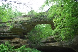
Natural Bridge State Park's natural bridge arches over rockshelter: Joshua Mayer (wackybadger), CC BY-SA 2.0, via Flickr @ https://www.flickr.com/photos/wackybadger/4286160681/

natural bridge (above) arches over rockshelter (right lower foreground: Wisconsin Department of Natural Resources, CC BY-ND 2.0, via Flickr @ http://www.flickr.com/photos/widnr/6560669739/

"Múk-a-tah-mish-o-káh-kaik, Black Hawk, Prominent Sac Chief," 1832 oil on canvas by George Catlin (1796-1872): Cliff (cliff1066™), CC BY 2.0, via Flickr @ http://www.flickr.com/photos/nostri-imago/3406980155

"Tshi-Zun-Hau-Kau (He- Who-Runs-with-Deer)," 1832-33 oil on canvas by Henry Inman (1801-1846)(M.H. deYoung Museum): Wmpearl, Public Domain (CC0 1.0), via Wikimedia Commons @ http://commons.wikimedia.org/wiki/File:'Tshi-Zun-Hau-Kau_(He-Who-Runs-with-Deer)'_by_Henry_Inman.JPG

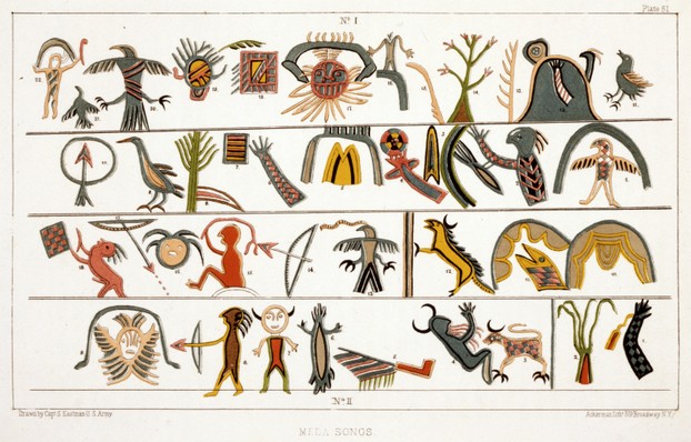
"Pictorial notation of an Ojibwa music board," c1820 drawing by Seth Eastman (1808–1875): Library of Congress Prints/Photographs, Public Domain, via Wikimedia Commons @ http://commons.wikimedia.org/wiki/File:Meda_songs,_1851.jpg

Northern Bedstraw (Galium boreale) at Natural Bridge State Park in May: Joshua Mayer (wackybadger), CC BY SA 2.0, via Flickr @ https://www.flickr.com/photos/wackybadger/4286161503/

two hiking trails at Natural Bridge State Park: McGhiever, CC BY-SA 2.5, via Wikimedia Commons @ http://en.wikipedia.org/wiki/File:NaturalBridgeStateParkWImap.jpg

paper birch in January: Wisconsin Department of Natural Resources, CC BY-ND 2.0, via Flickr @ http://www.flickr.com/photos/widnr/6511600331/

shagbark hickory syrup: Vegan Feast Catering, CC BY 2.0, via Flickr @ https://www.flickr.com/photos/veganfeast/4523912259/

wild columbine (Aquilegia canadensis) in mid-June at Ferry Bluff (State Natural Area 217), 14 miles (22k) south of Natural Bridge: Joshua Mayer (wackybadger), CC BY SA 2.0, via Flickr @ https://www.flickr.com/photos/wackybadger/4302059441/

November's wintry sky: McGhiever, CC BY-SA 2.5, via Wikimedia Commons @ https://en.wikipedia.org/wiki/File:NaturalBridgeStateParkWI.jpg

verdant splendor in May: Joshua Mayer (wackybadger), CC BY SA 2.0, via Flickr @ https://www.flickr.com/photos/wackybadger/4286158825/


multi-purpose plant, applied in treatment of diarrhea and stomach/intestinal ailments, also used as aphrodisiac
wild columbine (Aquilegia canadensis) in mid-June at Ferry Bluff (State Natural Area 217), 14 miles (22k) south of Natural Bridge

Sources Consulted


Voigt, L.P. Approval of final master plan for Natural Bridge State Park, Sauk County. Madison, Wisconsin: State of Wisconsin Department of Natural Resources, June 9, 1975. Last accessed May 21, 2012.

  • Available at: http://dnr.wi.gov/master_planning/ completed_archive/ parks_trails/ natural_bridge/natural_bridge.pdf


fallen tree over path in Natural Bridge State Park
verdant splendor in May
the end which is also the beginning

Explorer's Guide 50 Hikes in Wisconsin: Trekking the Trails of the Badger State (Second Edition)

This book emphasizes not only the flora and fauna but also what each trail has to tell people of all ages about Wisconsin and about the region’s past. Hikes herein range from 1.5 to just over 9 miles in length and cover all areas of the state.
Wisconsin-themed books

Wisconsin Watercolor Map: black t-shirt ~ Available via AllPosters

Wisconsin Watercolor Map
Ad AllPosters

Me and my purrfectly purrfect Maine coon kittycat, Augusta "Gusty" Sunshine

Gusty and I thank you for reading this article and hope that our product selection interests you; Gusty Gus receives favorite treats from my commissions.
DerdriuMarriner, All Rights Reserved
Updated: 04/04/2024, DerdriuMarriner
 
Thank you! Would you like to post a comment now?
39

Comments

Only logged-in users are allowed to comment. Login
DerdriuMarriner on 09/29/2013

MikeRobbers, Natural Bridge is both a natural beauty and natural fun since everything is at the viewer's pace and since the viewing is really gorgeous. Thank you visiting and commenting.

MikeRobbers on 09/29/2013

A very good article my friend and beautiful imagery. Can see exactly why it is a natural wonder!

DerdriuMarriner on 09/29/2013

JohnnyKnox, Natural Bridge indeed is a natural wonder, so I'm happy that you find that wonder honored in my presentation. Thank you for visiting and commenting.

JohnnyKnox on 09/28/2013

Seems as a wonderful place and you did a great presentation!

You might also like

Parfrey's Glen in Wisconsin: a Creek, a Gorge, and a Waterfall...

Parfrey's Glen is Wisconsin's first Natural Area. It offers visitors beautifu...

Wisconsin's Henry S Reuss Ice Age Visitor Center: Kettle Morai...

The Henry S. Reuss Ice Age Visitor Center has exhibits on Wisconsin's Ice Age...


Disclosure: This page generates income for authors based on affiliate relationships with our partners, including Amazon, Google and others.
Loading ...
Error!