Ker Place in Onancock, Accomack County, Eastern Shore Virginia

by DerdriuMarriner

Ker Place houses Eastern Shore Historical Society museum and offices in a Federal home on two acres of Market Street, Onancock, Accomack County, Virginia.

Ker Place models urban sustainability of historic country-homes

Ker Place acquaints locals and visitors with Eastern Shore Historical Society activities and displays by way of an eighteenth-century Federal home on two landscaped acres (0.81 hectares) with boat shed and parking on downtown Onancock’s Market Street in Accomack County, Eastern Shore Virginia. It belongs on lists of Commonwealth landmarks and national places with historic sites to see and modern things to do through:
• garden tours;
• on-the-lawn concerts;
• public-access exhibits, interiors, memorabilia;
• special events;
• wedding venues.

It counts respectively atypically and typically among Eastern Shore architectural styles by:
• attaching a two-story house to a one-story colonnade, albeit subsequently altered into a two-story wing, and an outside kitchen, albeit subsequently removed;
• not building first a one-and-a-half-story little house.

*****
Email: [email protected]
Fax: 757–787–4271
Hours, March – December, with private tours/rental arrangements by appointment and tours on the hour and the last beginning at 2:00 p.m.: Thursday, Friday, Saturday, 11:00 a.m –3:00 p.m.
Mailing address: Historical Society Eastern Shore of Virginia, P.O. Box 179, Onancock, VA 23417
Physical address: 69 Market Street, Onancock, VA 23417
Telephone: 757–787–8012
Website: http://www.shorehistory.org/ker-place/

*****

Onancock Creek stretches inland for about 4 miles (6.4 kilometers) and cups downtown Onancock with a curved E shape formed by the creek's West Branch and Central Branch with Titlow Creek.

photo by American environmental economist Linwood Pendleton; Sunday, Aug. 1, 2010, 19:12:49

Ker Place nurtures preservationism in original entry ports


Onancock designates the tribe ruled by King Ekeeks, as:

  • Bay acquaintance of Captain John Smith (1580?-1631);
  • grain trader to Jamestown’s first settlers.

It enjoys uniqueness with Norfolk as the Commonwealth’s extant original 50-acre (20.23-hectare) entry ports and market towns mandated by the 1680 Virginia Act of Cohabitation for each of 19 colonial settlements. It finds its place in seventeenth-century grain- and tobacco-trading and storehouse- and wharf-building as Port Scarborough, in honor of Edmund Scarborough (1617–1671), as:

  • brother of Sir Charles Scarborough (1615–1693), physician to Kings Charles II (1630-1685), James II (1633-1701), and William III (1650-1702);
  • developer of Eastern Shore patented land tracts and Chesapeake Bay trading ventures. 


photograph of Ker Place by Historic American Buildings Survey (HABS), established by National Park Service (NPS) in 1933 to document representative sampling of U.S. architectural heritage

Ker Place, Crockett Avenue & Market Street, Onancock, Accomack County, Virginia's Eastern Shore, southwest Delmarva Peninsula

Ker Place owes exterior, interior integrity to owner-occupancies


Owner-occupancy by descendants and relatives gives historic landforms and landmarks fighting chances at intact authenticity. Ker Place has documented survivalism as:

  • place developed by George Corbin (1744-1793);
  • plantation inherited by Agnes Drummond Corbin’s (1775-1814) husband John Shepherd Ker (1768-1806);
  • property purchased --  with 7 acres (2.83 hectares) -- from Ker/Snead family heirs by George W. Powell (1823-1885) in 1875.

Its sustainability nowadays is guaranteed by:

  • owner-operatorship by the Eastern Shore Historical Society since 1960;
  • registry with Virginia Landmarks Register since December 2, 1969, and National Register of Historic Places since February 26, 1970;
  • restoration by The Garden Club of Virginia landscape architect Rudy J. Favretti (born 1932) in 1981. 


impressive, welcoming entrance to Ker Place

69 Market Street, Onancock Historic District; Tuesday, April 23, 2013, 07:24

Ker Place provides fun events in beautiful settings


Architectural historians judge as of notable integrity:

  • bracket-corniced gable-roof base and pediments, English and Flemish bond brickwork respectively below and above molded water-tables, rubbed brick-splayed window arches and frames;
  • elaborate, formal trimmed dining room, entrance hall, and reception room and Wellford-decorated and molded drawing-room cornice and mantel.

Landscape architects know of no archaeological or historical records regarding gardening the original 346-acre (147.31-hectare) tract. But locals and visitors always leave impressed with Favretti-directed landscaping of:

  • bayberry, beauty-bush, beech, boxwood;
  • camellia, chaste-tree, crape myrtle;
  • day-lily, Deodar cedar, dogwood;
  • fig, flame-azalea, fringe-tree;
  • hardy orange, holly, honeysuckle, horse-chestnut;
  • lilac;
  • mallow, maple;
  • pagoda-tree, pear, pecan, periwinkle, pomegranate;
  • rhododendron;
  • southern magnolia, summer-sweet, sweetgum, sweet-shrub, sycamore;
  • tulip poplar;
  • Virginia red-cedar;
  • white oak, willow oak. 


photograph of Ker Place by Historic American Buildings Survey (HABS)

inscribed Feb. 26, 1970, in NRHP (National Register of Historic Places), Dec. 02, 1969, in VLR (Virginia Landmarks Registry)

Acknowledgment


My special thanks to talented artists and photographers/concerned organizations who make their fine images available on the internet.


Image Credits


Onancock Creek stretches inland for about 4 miles (6.4 kilometers) and cups downtown Onancock with a curved E shape formed by the creek's West Branch and Central Branch with Titlow Creek.
photo by American environmental economist Linwood Pendleton; Sunday, Aug. 1, 2010, 19:12:49: eutrophication&hypoxia, CC BY 2.0, via Flickr @ https://www.flickr.com/photos/48722974@N07/6311800395/

photograph of Ker Place by Historic American Buildings Survey (HABS), established by National Park Service (NPS) in 1933 to document representative sampling of U.S. architectural heritage
Ker Place, Crockett Avenue & Market Street, Onancock, Accomack County, Virginia's Eastern Shore, southwest Delmarva Peninsula: No known restrictions, via Library of Congress Prints & Photographs Online Catalog (PPOC) @ http://www.loc.gov/pictures/item/va0031.photos.159709p/

impressive, welcoming entrance to Ker Place
69 Market Street, Onancock Historic District; Tuesday, April 23, 2013, 07:24: Joel Bradshaw, Public Domain (CC0 1.0), via Wikimedia Commons @ https://commons.wikimedia.org/wiki/File:Onancock-Ker-Place.JPG

photograph of Ker Place by Historic American Buildings Survey (HABS)
inscribed Feb. 26, 1970, in NRHP (National Register of Historic Places), Dec. 02, 1969, in VLR (Virginia Landmarks Registry): No known restrictions, via Library of Congress Prints & Photographs Online Catalog (PPOC) @ http://www.loc.gov/pictures/item/va0031.photos.159710p/

Ker Place's hometown, Onancock, originally was founded as Port Scarborough on Onancock Creek.
display in shop window in Onancock, a port town of history and humor; Monday, April 7, 2008: Jim Brickett (jimbrickett), CC BY-ND 2.0, via Flickr @ https://www.flickr.com/photos/jimbrickett/2394662629/

Onancock's Wharf and Marina is located about 0.5 miles (0.8 kilometers) west of Ker Place.
photo by American environmental economist Linwood Pendleton; Sunday, Aug. 1, 2010, 18:35:41: eutrophication&hypoxia, CC BY 2.0, via Flickr @ https://www.flickr.com/photos/48722974@N07/6311799331/


Ker Place's hometown, Onancock, originally was founded as Port Scarborough on Onancock Creek.

display in shop window in Onancock, a port town of history and humor; Monday, April 7, 2008

Sources Consulted


“Agnes Drummond Corbin Ker [1775 – 1814].” Find A Grave > Memorial #106299529 Created by Linda Dukes. Retrieved September 2015.

  • Available @ http://www.findagrave.com/cgi-bin/fg.cgi?page=gr&GScid=2506345&GRid=106299529& Ancestry.com. 2012. U.S., Find A Grave Index, 1600s – Current [database on-line]. Provo, UT, U.S.A.: Ancestry.com Operations, Inc.

Bemiss, Margaret Page. 2009. Historic Virginia Gardens: Preservation Work of The Garden Club of Virginia, 1975 – 2007. Charlottesville, VA, U.S.A.; and London, England, U.K.: University of Virginia Press.

“Col George Corbin [1744 – 1793].” Find A Grave > Memorial #114656107 Created by David Hargis. Retrieved September 2015.

  • Available @ http://www.findagrave.com/cgi-bin/fg.cgi?page=gr&GRid=114656107&ref=acom

“Eastern Shore of Virginia Historical Society.” Facebook > ESHS. Retrieved September 2015.

  • Available @ https://www.facebook.com/ESVHS

“George W. Powell [1825? – Jul 1885 married Margaret A. Powell] in the Virginia, Deaths and Burials Index, 1853 – 1917.” Virginia, Deaths and Burials Index, 1853 – 1917 [database on-line]. Provo, UT, U.S.A.: Ancestry.com Operations, Inc., 2011. Retrieved September 2015.

  • Available @ http://search.ancestrylibrary.com/cgi-bin/sse.dll?gss=angs-c&new=1&rank=1&msT=1&gsfn=george+w&gsln=powell+&mswpn__ftp=Northampton+County%2c+Virginia%2c+USA&mswpn=2192&mswpn_PInfo=7-%7c0%7c1652393%7c0%7c2%7c3245%7c49%7c0%7c2192%7c0%7c0%7c&MSAV=1&msbdy=1825&catbucket=rstp&uidh=lx5&pcat=34&h=516644&recoff=5+6+7+36+48+61&db=FSVirginiaDeath&indiv=1&ml_rpos=1

“John Shepherd Ker [1768 – 1806].” Find A Grave > Memorial #106299331 Created by Linda Dukes. Retrieved September 2015. Available @ http://www.findagrave.com/cgi-bin/fg.cgi?page=gr&GRid=106299331&ref=acom

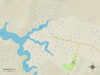
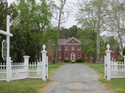
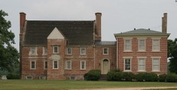
“Ker Place.” Historical Society Eastern Shore of Virginia. Retrieved September 2015.

  • Available @ http://www.shorehistory.org/ker-place/

“Ker Place, Eastern Shore of Virginia Historical Society.” Virginia Is For Lovers > Historic Sites. Retrieved September 2015.

  • Available @ http://www.virginia.org/Listings/HistoricSites/KerPlaceEasternShoreofVirginiaHistoricalSociety/

“Ker Place Herb and Kitchen Garden.” Eastern Shore Virginia Master Gardeners > Projects. Retrieved September 2014.

  • Available @ http://www.easternshoremastergardeners.com/ker-place-herb-and-kitchen-garden.html

“Kerr Place.” National Register of Historic Places Inventory – Nomination Form. United States Department of the Interior National Park Service form 10-300 (July 1969). Retrieved September 2015.

  • Available @ http://www.dhr.virginia.gov/registers/Counties/Accomack/273-0003_Kerr_Place_1970_Final_Nomination.pdf

Loth, Calder. 1999. The Virginia Landmarks Register. 4th Edition. Charlottesville, VA, U.S.A.: University Press of Virginina for the Virginia Department of Historic Resources. 

Rothery, Agnes. 1954. Houses Virginians Have Loved. New York, NY, U.S.A.: Bonanza Books.

“Severn Eyre [1731 – 1773]. Find A Grave > Memorial #125797008 Created by Linda Dukes. Retrieved September 2015.

  • Available @ http://www.findagrave.com/cgi-bin/fg.cgi?page=gr&GRid=125797008

Whitelaw, Ralph T. 1968. Virginia’s Eastern Shore. Vol. II. Gloucester, MA, U.S.A.: Peter Smith.


Onancock's Wharf and Marina is located about 0.5 miles (0.8 kilometers) west of Ker Place.

photo by American environmental economist Linwood Pendleton; Sunday, Aug. 1, 2010, 18:35:41
the end which is also the beginning

The Virginia Landmarks Register, 4th edition

Each of over 1800 entries features photograph + brief description and history.
Ker Place information

Political Map of Onancock, VA: Available as Photographic Print and as Premium Poster ~ Available now via AllPosters

Map shows Ker Place (noted with green marker as Kerr Place), which is sited almost equidistantly between North Branch (upper left) and Central Branch (center) of Onancock Creek.
Political Map of Onancock, VA

Me and my purrfectly purrfect Maine coon kittycat, Augusta "Gusty" Sunshine

Gusty and I thank you for reading this article and hope that our product selection interests you; Gusty Gus receives favorite treats from my commissions.
DerdriuMarriner, All Rights Reserved
Updated: 04/04/2024, DerdriuMarriner
 
Thank you! Would you like to post a comment now?
12

Comments

Only logged-in users are allowed to comment. Login

You might also like

Bacon’s Castle: 350th Arthur Allen House Anniversary, Surry, V...

Bacon’s Castle and oldest North American formal garden host the 350th Arthur ...

George Washington: The United States President Who Designed a ...

First U.S. President George Washington derived personal satisfaction from com...


Disclosure: This page generates income for authors based on affiliate relationships with our partners, including Amazon, Google and others.
Loading ...
Error!