2017 Seasonal Hurricane Predictions and Names

by CruiseReady

The 2017 Atlantic Basin Hurricane Season arrives on June 1. What tropical activity will this year bring? Predictions from five sources; Names that will be used .

Although there was a rare named tropical storm in April this year, that doesn’t change the date of the official beginning of the 2017 Hurricane Season. That remains June 1, as always. Just because a system blooms into an actual Tropical Storm or Hurricane earlier in the year, it doesn’t change the start of the season. But, it does give us a slightly unusual start for 2017.

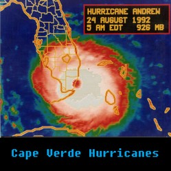
Will any names make history this year, like Katrina, Sandy, and Matathew did in recent years? What are the names for this year, and how were they chosen? The list is ready, and has been for years. You’ll find it here.

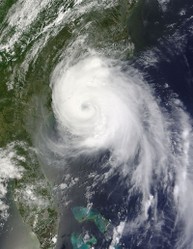
When a low pressure system strengthens to Tropical Storm status, it is named. Some of those named storms get even stronger and turn into hurricanes. How many of those will turn into hurricanes?

I follow several prominent hurricane forecasting organizations. They all make hurricane season predictions about how active they think the tropics will be in the coming months.
What are they saying? I've made a handy chart to show the forecast numbers from Colorado State University, Tropical Storm Risk, Weather Services International (The Weather Channel), Global Weather Oscillations, and, of course, the National Hurricane Center.

How accurate are these preseason forecasts? Read on to find out.

When is the Atlantic Hurricane Season?

June 1 Through November 30

 When is the Atlantic Hurricane Season?

The official dates of the Atlantic Basin Hurricane Season are June 1   through November 30

The peak, or most busiest, part of the season is usually from about the second week of August through late October.

 Atlantic Hurricane Basin


 North Atlantic Hurricane Basin Map


The Atlantic Hurricane Basin includes the Atlantic Ocean north of the equator, the Caribbean Sea, and the Gulf of Mexico.

Hurricane Franklin

Becomes First Landfalling Atlantic Hurricane of 2017

10 August 2017

 Hurricane Franklin made landfall about 1:00 am near the town of  Lechuguillas, in the Mexican State of Veracruz, with sustained winds of 85 mph.

 The system will be moving across Mexico today.  Rainfall of some 4 to 8 inches are possible in affected areas, with some isolated amounts of over a foot.  Flash floods and mudslides will continue to be a danger as the storm moves towards the Mexican Pacific coast throughout the day today.

By morning, Franklin had already weakened to a Tropical Storm, and is expected to degenerate into a Depression later today.  However, even a Tropical Depression can pose serious water related dangers.


Please refer to the NHC or your local weather bureau for official news.


Hurricane Franklin Storm Franklin

August 9, 2017
Hurricane Franklin Closes in on Mexican Coast
Hurricane Franklin Closes in on Mexic...
Franklin Projected Path on Aug 10

A NOAA All Hazards Alert Radio

It's No Ordinary Radio
Midland WR120EZ NOAA Weather Alert All Hazard Public Alert Certified Radio with SAME, Trilingual ...

Every U.S. home in any area where any type of severe weather can be a threat should consider a NOAA Weather Radio an essential.. It does things ordinary radios just can't, and it could help to save your life.

View on Amazon


PREDICTIONS


2017 HURRICANE SEASON PREDICTIONS

What will this year bring?

Crystal Ball
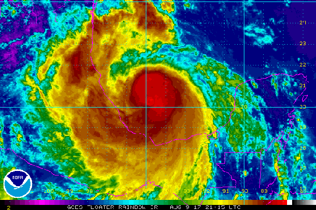
Wondering if the tropics will be in the news a lot this year?   The experts have read their crystal balls, and some of them  seem to think so!  OK - maybe they don't really read a crystal ball.  A whole lot actually goes into these hurricane season forecasts.

As a group, most of the forecasters are saying this year will be right around average.   An average season, over the last 30 years, we have seen 12 named storms, with 6 of those becoming hurricanes, and 2 -  3 making it to Major Hurricane strength. 

Only one of the forecast organizations that I follow  - GWO - is forecasting an above average season, and they are predicting a real doosie! 


Image Source


*A tropical cyclone is any system that is borne over tropical waters (or even sub tropical ones), and exhibits a closed low level circulation.  Tropical depressions, tropical storms, and hurricanes are all tropical cyclones.


2017 Hurricane Season Predictions

From Five Different Expert Sources

The long range forecasts for this year have been made by Tropical Storm Risk, Global Weather Oscillations, WSI (a division of The Weather Company, and affiliate of the Weather Channel on TV),   Colorado State University, and or course, NOAA / NHC (National Hurricane Center).   

 Here’s a handy chart showing what each of those organizations has predicted.  The three columns show forecasts for total number of Named Storms, how many of those will become Hurricanes and which hurricanes will intensify into Major Hurricanes.

For comparison, the first line shows an average over the last 30 years in each of those categories.


 2016 PRESEASON PREDICTIONS


NS

H

MH

30 Yr. Avg.

12.1

6.4

2.7


TSR (APR)

11

4

2

GWO (APR)

16

8

4

WSI (APR)

12

6

2

CSU (JUN)

14

6

2

NHC (MAY)

 11-17

 5-9  

  2-4


NS= Named Storms; H=Hurricanes; MH= Major Hurricanes (Category 3 or stronger)


AUGUST UPDATES

 NHC (AUG)

 14 - 19

 5 - 9   

2 - 4

TSR (AUG)

 17

 7

 3 

CSU  16  8


Hurricane Landfall Probabilities for 2017

Where Might a Big Storm Hit?

Hurricane Arthur makes landfall, July 3, 2014

Hurricane Arthur makes landfall, July 3, 2014

We already know that some forecasters are predicting a season that is more active that average.  Maybe it will be, and maybe not, but WHERE might this year’s storms make landfall?

Really, no one knows for sure.  But, the good Dr. Philip Klotzbach, at CSU's Tropical Meteorological Project, is bold enough to assign some numerical probabilities to certain broad regions. So is David Dilley, of Global Weather Oscillations. Here's what the two of them have to say about 2017.


GWO Landfall Predictions: 

6 Landfalling named storms for the United States, 3 of which will be Hurricanes.  He further says that 1 or 2 of the hurricanes to make landfall could be strong, or major hurricanes of category 3 or higher.


CSU Landfall Predictions: 

For the United States overall:  

TS - 69% chance of one or more Tropical Storm landfalls

H - 75% chance of a Hurricane strike (Hurricanes of any strength)

MH - 42% chance for a hit from a Major Hurricane  


For the Gulf Coast (the area from the Florida Panhandle to the Texas / Mexico border):

TS -48%; H - 49%; MH -24%


Peninsula Florida and the East Coast:  

TS  41%; H - 51%; MH - 24%


For the Caribbean: 

TS - 73% ; H - 65%; MH - 34%


NAMES


2017 Atlantic Basin Hurricane Names

This Year's List

A couple of the premier forecasting organizations increased their numbers with their August update.  But that doesn’t necessarily mean we’ll use more than we otherwise would. Maybe that will be so, and maybe not.  Yes, it's looking like we may, but still, let's hope for the NOT...

I'll update the listing as new  tropical cyclones are officially named.


NAME

Dates

Cat.

NAME

Dates

Cat.

Arlene

04/19 - 21

 TS

Lee


Bret

 06/19 - 20

 TS

Maria


Cindy 

06/20 -  23

 TS 

Nate


Don

 07/17 - 19

 TS

Ophelia


Emily

 07/31 -  08/02

 TS

Philippe


Franklin

  08/07 -  

 H1 

Rina


Gert


Sean


Harvey


Tammy


Irma


Vince


Jose


Whitney


Katia


Is your name on the list of Atlantic Basin Hurricane Names for 2017?

If so, you might have a tropical storm or hurricane named after you this year! 

Might They Name a Storm After You This Year?

Do You See Yourself on the List?

HURRICANE NAMES

How are Hurricane Names Chosen?

Although most of us think of the names used to designate tropical weather systems as ‘the Hurricane Names,’ that’s inaccurate.     A storm gets named when it reaches tropical storm strength.  (Sustained winds of 39 mph or greater) Not all tropical weather systems turn into hurricanes. However, most people still refer to the names on the list as "hurricane names."

The ABCs of Hurricane Names

The names for this year, and even the next five years, have long since been chosen.

There are six established lists that are used in rotation year after year.  Each alphabetical list has 21 names on it, alternating between male and female.  This year’s list begins with a masculine name.  Next year, a feminine one will be up first.


Image source

Tropical Weather Systems

Can’t Read Calendars.

Calendar
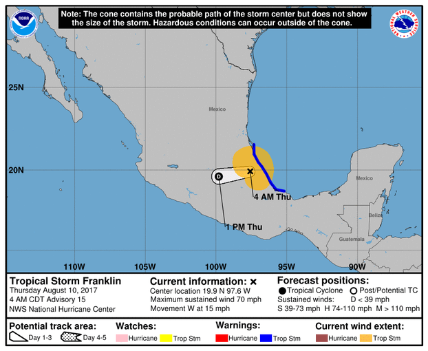
Yes, the season begins on June 1st, and ends on November 30th.  But tropical weather systems can't read calendars. Sometimes there are early or late Storms


Early Storms are fairly common.  In 2012, we had not one, but two, in May


As for late storms -  2005 saw Hurricane Epsilon (Nov 29 - Dec 9), and Tropical Storm Zeta ( Dec 30 - Jan 7)

 Incredibly, Hurricane Zeta was named on December 31, 2005, and dissipated on January 7, making it only the second named system in recorded history to span two calendar years!

Image from Pixabay (P.D.)

Facts About Hurricane Names

Things That are Fun to Know

Here are a few things you might like to know about the naming and naming conventions that are used for tropical weather systems.

  • The World Meteorological Organization is in charge of the lists.
  • The lists were first established in 1953, with all feminine monikers.
  • Naming alternate storms after men was introduced in 1979.
  • Some Names Get Retired.  If a storm is particularly devastating, the name could be taken out of service, out of respect for those affected.  For example, Katrina was retired after the 2005 season.
  • The letters Q, U, X, Y, and Z are not used at all, for obvious reasons.
  • This year’s list was last used in 2009.  There were no retirements after the last use, so it stays exactly the same as it was then.
  • These same names will be used again in 2021, unless there are retirements.  In that case, the replacement names will be of the same gender and begin with the same letter as those being replaced.


What If They Run Out of Names?

Has That Ever Happened Before?


storm namesThere are exactly 21 storm names on each of the six lists used for yearly tropical storm names.

What happens if more than 21 tropical systems get strong enough to get named?

Do they start over again withe that year's "A" name?  NO

Do they 'borrow' names from next year's list?  They won't do that, either.

Do they just let the guy on duty at the time pick name #22?  Of course not.


Above image is my own


Here's What Happens 

The 22nd named storm will be named ALPHA, the first letter of the Greek alphabet.  

Any subsequent storms that season will be named for other letters of the Greek Alphabet, in order.

Has this ever happened before?

Yes, once - just one single time -  in the last 60 years.  

The 2005 hurricane season, had a record-breaking 27 named storms!

After the last name on the list, which was Wilma, the additional storms were called:  Alpha, Beta, Gamma, Delta, Epsilon, and Zeta

A Special NOTE

This page is not an official weather site.  I am a long time coastal resident with a keen interest in tropical weather, not a professional meteorologist..  I have simply made it my business to learn as much as I can, season by season.

I have always been happy to share some of the things I have learned through decades of exposure to the threat of hurricane strikes.  I am still learning and still sharing. 

For authoritative information on weather - especially current severe weather events - please consult an official weather source.  Here are a couple of good ones:

National Hurricane Center

Weather Underground

If you’d like to read the very detailed annual predictions from a real expert -  Dr. Phil Klotzbach of Colorado State University - you can find his report here, in PDF format:

Extended Range Forecast of Atlantic Seasonal Hurricane Activity and Landfall Strike Probability for 2017  


Other Pages about Hurricanes

by the same author
More hurricane deaths are associated with water than with high winds. And the worst of a hurricane's water often comes from storm surge. How much do you know about surge?
Learn a little about Cape Verde Hurricanes, and why some weather watchers consider them a real threat. Why? Because knowing what you may face is part of Emergency Preparedness

2016 Seasonal Recap


REMEMBERING LAST YEAR'S TROPICAL WEATHER 


HIGHLIGHTS

from the 2016 Hurricane Season

2016 turned out to be an above average year for tropical activity.  Some of the things that some of us will remember are:

  • Hurricane Alex formed in the month of January.  The last time that happened was 1938. 
  •  Hurricane Matthew was the first Cat 5 storm since Felix in 2007.  He was costly and deadly, causing over $15 Billion in damages, and killing 603 people.
  • The public continued to underestimate the potential danger when it's "only a tropical storm."  Hundreds of thousands suffered through power outages during and after these storms.  In addition to the widespread damage to structures from flooding, nine people lost their lives to tropical storms in 2016.
  • October saw the first time since 1964 that two hurricanes of category 2 or stronger were spinning in the Western Atlantic at the same time.  Those two were Matthew and Nicole.
  • The final hurricane of the season, Otto, made a name for himself in two ways.  1) On November 23, he intensified into a hurricane in the Caribbean, the latest storm to do so there.  3)  He also became the first system on 30 years to cross over from the Atlantic Basin to the Pacific Basin while maintaining named storm status.

Last Year’s Hurricane Predictions

How Did the Experts Do in 2016?

   Tropical Weather System Tracks during the 2016 Atlantic Hurricane Season


How accurate were last year's hurricane season forecasts?  See for yourself! What follows is a chart showing the predictions of several of the big names in tropical meteorology, and the actual numbers for the 2015 season.

Shown are the numbers each organization forecast for Named Storms (NS); Hurricanes (H); and Major Hurricanes (MH) of Category Three or stronger.  These numbers are from are their last hurricane predictions before the season began.  The first line shows what actually happened.


  NS H MH
ACTUAL. 15 7 4
       
TSR (APR) 12 6 2
GWO (JAN) 17 9
WSI (APR) 15  9 4
CSU (APR) 13 6
NHC (MAY)  10-16 4-8  1-4


The breakdown of the actual 2016 season activity of 15 Named Storms, with 11 becoming hurricanes, and 4 of those reaching major hurricane strength went like this:

Category # NAME(s)
T.S. 4 Bonnie, Colin, Danielle,. Fiona
1 7 Alex, Earl, Hermine, Ian, Julia, Karl, Lisa
2 0 N/A
3 2 Gaston, Otto
4 1 Nicole
5 1 Matthew


Updated: 08/10/2017, CruiseReady
 
Thank you! Would you like to post a comment now?
6

Comments

Only logged-in users are allowed to comment. Login
blackspanielgallery on 06/20/2016

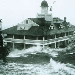
Early storms might be a good thing. One thing these storms do is churn the waters, bringing up cooler water to the surface. This does not last but can help in the short time. Of course tropical storm Cindy came before hurricane Katrina, but was rather weak. Why did Katrina not cool the gulf and prevent Rita and Wilma? Well, Rita tracked farther south, and Wilma even farther south, so they did not weaken due to the churning. Their tracks did not interact enough.

CruiseReady on 06/20/2016

June 20, 2016: A record has already been tied this season. June is usually a fairly inactive month for tropical systems, but this year is different. 2016 marks only the fourth time in history that THREE named storms have formed in the month of June. The other years in which that happened were 1886, 1936, and 1968. All even numbered years.... hmmm.

CruiseReady on 07/18/2015

In the last couple of years, they've narrowed the cone overall... so, in that sense, they have recently gotten more accurate overall. I don't think the shrinking of the forecast cone is something that most people have noticed, however,

DerdriuMarriner on 07/17/2015

CruiseReady, It's interesting that retiring hurricane names and sports numbers are honors, for the casualties in the first case and the bearers in the second. Of course, one wants there to be more athletic retirements than weather, but it's still comforting for survivors to know that their loved ones are being remembered.

In another direction, I always chuckle over the climatologist's and meteorologist's excuse that forecasts get more accurate the closer the data get to the event: so one hopes!

CruiseReady on 05/11/2015

I do, indeed, love it here! Lucky for you, those remnants don't make it over to you all that often. Then, you would have to worry about both summer and winter storms. I think the winter ones alone would do me in.

frankbeswick on 05/11/2015

We in Britain sometimes get the remnants of hurricanes. When we do their path is to come up through the Western approaches south of Ireland and come ashore in central southern England, then they track North East before decaying. In the North West of England where I am, we get the sides of the storm. I am more personally concerned about winter storms in the North Atlantic, which can badly hit Northern Britain.

I can see why you love living near the sea, Cruiseready, for I have a friend who grew up in such an environment and now deeply misses it. My daughter lives near a sheltered stretch of the coast of Anglesey in North Wales and loves where she lives.

CruiseReady on 05/11/2015

I think it would be much harder to live far inland, away from the sea breeze and salt air! And I can't imagine living with the threat of tornadoes, which seem to be much more frequent, and give a lot less warning of their approach than a tropical storm.

Mira on 05/11/2015

Interesting article. Like Pam, I learned a few things, and it was an enjoyable read, even though it talked about devastating storms and hurricanes. It must be really hard to live on coastal areas affected by such storms.

CruiseReady on 05/11/2015

Many thanks for the kind words. Yes, and they really had to use a lot of those 'extra' names in 2005. Here's hoping they never have to do THAT again.

dustytoes on 05/11/2015

I also meant to say that this page is interesting and well done. I did not know how they named storms once they ran out of alphabet letters.


You might also like

Hurricane Danger: Storm Surge

More hurricane deaths are associated with water than with high winds. And the...

What Are Cape Verde Hurricanes?

Learn a little about Cape Verde Hurricanes, and why some weather watchers con...


Disclosure: This page generates income for authors based on affiliate relationships with our partners, including Amazon, Google and others.
Loading ...
Error!