The Cascadia Subduction Zone lies within the Pacific Ring of Fire. The Pacific Ring refers to volcanic arcs and oceanic trenches that partly encircle the Pacific. The Ring of Fire is a zone of frequent earthquakes and volcanic eruptions.
Trenches are shown in blue-green. The volcanic island arcs, although not labelled, are parallel to, and always landward of, the trenches. Illustration by Jane B. Russell.
W. Jacquelyne Kious and Robert I. Tilling, "Understanding plate motions," This Dynamic Earth (February 1996): US Geological Survey, Public Domain, via USGS Geomaps @ https://pubs.usgs.gov/gip/dynamic/understanding.html
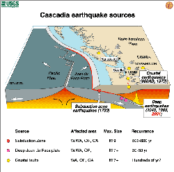
Cascadia earthquake sources: subduction zone, deep Juan de Fuca plate, crustal faults
Pacific Northwest geologic mapping and urban hazards: US Geological Survey, Public Domain, via USGS Geomaps @ http://geomaps.wr.usgs.gov/pacnw/pacnweq/index.html
Cascadia earthquake sources: map of Juan de Fuca plate
Pacific Northwest geologic mapping and urban hazards: US Geological Survey, Public Domain, via USGS Geomaps @ http://geomaps.wr.usgs.gov/pacnw/pacnweq/index.html
"Tsunami Forecast Model Animation: Cascadia 1700" (1:20)
Uploaded January 26, 2015, by PacificTWC (Pacific Tsunami Warning Center) to YouTube ~ URL: https://www.youtube.com/watch?v=4W2iUl0VB8c
The Earth's layer on which we live is broken into a dozen or so rigid slabs (called tectonic plates by geologists) that move relative to one another.
illustration of the world's tectonic plates by Jane B. Russell
W. Jacquelyne Kious and Robert I. Tilling, "Historical perspective," This Dynamic Earth (February 1996): US Geological Survey, Public Domain, via USGS Publications Warehouse @ https://pubs.usgs.gov/gip/dynamic/historical.html#anchor9449934
Part of the Pacific Ring of Fire, the Cascade Volcanic Arc extends for a distance of over 700 miles (1,100 kilometers) from southwestern British Columbia through Washington and Oregon to Northern California.
Subduction along Cascadia Subduction Zone is responsible for the arc's formation.
NASA WorldWind image; Black Tusk graphics: NASA World Wind, Public Domain, via Wikimedia Commons @ https://commons.wikimedia.org/wiki/File:Cascade_Volcanic_Arc.jpg

")


")


 Mailing Addresses for 2025 Form 4868 Extending 1040 and 1040SR April 15, 2026, Due Date9 days ago
 Mailing Addresses for 2025 Forms 1040 and 1040SR Filed in 202611 days ago
 Are Hawaiian Huakai Po Nightmarchers Avenging Halloween Thursday?on 10/02/2024
 Mailing Addresses for 2023 Form 4868 Extending 1040 and 1040SR April 15, 2024, Due Dateon 04/15/2024

Comments
The section Cascadia juggles three sea plates and one trench advises us that "Cascadia’s fault line from Cape Mendocino in northern California, through Oregon and Washington, to Vancouver Island off British Columbia in western Canada keeps low geo-historical profiles.
Cascadia’s 19 full margin ruptures of magnitude 9 and 22 partial margin ruptures of magnitude 8 in 10,000 years lead seismologists to rethink California’s upcoming mega-quake. Cascadia’s northern end from mid-Oregon to mid-Vancouver Island and southern end from Cape Mendocino to Newport, Oregon, manifest respectively recurrent intervals of 480 and 240 years. Dr. Kenji Satake of the Geological Survey of Japan and co-authors Kunihiko Shimazaki, Yoshinobi Tsuji, and Kazue Ueda note January 26, 1700, for Cascadia’s last mega-earthquake."
Couldn't it be quite compelling to collect Pacific-Coast native-american legends, lores, myths, stories and tales about the afore-considered Cascadia mega-earthquake of Tues., Jan. 26, 1700?
blackspanielgallery, Amen! Some seismologists describe an alternating pattern between the eastern and western Pacific Rim and suggest that the North American side is overdue for an earthquake since the Asian side had the Fukushima quake.
At any plate boundary there is concern. Some earthquakes generate tsunamis, but others do not. his is because f the direction of the movement of the earth, how does the plate itself move. A plate that has vertical movement is more likely to form a tsunami than a plate that moves laterally.