Chan, Kenneth. 29 December 2015. “(UPDATED) Magnitude 4.3 Earthquake Felt in Vancouver.” VanCity Buzz > Trending.
- Available @ http://www.vancitybuzz.com/2015/12/vancouver-earthquake/
Crawford, Tiffany. 30 December 2015. “Moderate Earthquake That Struck Near Saanich Felt Across Lower Mainland.” The Vancouver Sun > News.
- Available @ http://www.vancouversun.com/news/earthquake+magnitude+quake+strikes+near+saanich+felt+across+lower/11620989/story.html
“Did You Feel It? 4.3 Magnitude Earthquake Hits Near Victoria, B.C.” Kiro TV > News > December 30, 2015.
- Available @ http://www.kirotv.com/news/news/49-magnitude-earthquake-near-victoria-canada/nptDH/
Edmiston, Jake; and Postmedia News. 30 December 2015. “B.C. Earthquake Shakes Victoria and Vancouver Area: Buildings Rattle But No Damage Reported.” National Post > News > Canada.
- Available @ http://news.nationalpost.com/news/canada/earthquake-shakes-british-columbia-quake-measured-at-between-magnitude-4-3-and-4-8
“Here’s a Look at 5 of the Largest Earthquakes to Strike B.C.” Global News > Canada > December 30, 2015.
- Available @ http://globalnews.ca/news/2425915/heres-a-look-at-5-of-the-largest-earthquakes-to-strike-b-c/
Leung, Roberta. 30 December 2015. “Magnitude 4.3 Earthquake Felt off B.C.’s Coast.” FigMedia > News.
- Available @ http://figmedia.com/magnitude-4-3-earthquake-felt-in-vancouver/
Lum, Zi-Ann. 30 December 2015. “Victoria Earthquake Callers Prompt Police to Issue PSA About Using 911.” The Huffington Post > Edition> Canada > British Columbia.
- Available @ http://www.huffingtonpost.ca/2015/12/30/victoria-earthquake-2015-911_n_8895480.html?utm_hp_ref=canada-british-columbia&ir=Canada+British+Columbia
“Magnitude-4.4 Earthquake Shakes Southern California Suburbs.” Globe Gazette > News > National > December 30, 2015.
- Available @ http://globegazette.com/news/national/magnitude--earthquake-shakes-southern-california-suburbs/article_82f5ad2e-41c9-5f7b-844d-8ca178843919.html
McElroy, Justin; and Talmazan, Yuliya. 30 December 2015. “No Damage, Injuries Reported After Earthquake Rattles B.C.’s South Coast.” Global News > Canada > British Columbia.
- Available @ http://globalnews.ca/news/2425646/no-damage-injuries-reported-after-earthquake-rattles-b-c-s-south-coast/
Nagel, Jeff. 30 December 2015. “Earthquake Jolts B.C., Lights up Social Media.” Tri-City News > News.
- Available @ http://www.tricitynews.com/news/earthquake-jolts-b-c-lights-up-social-media-1.2141886
“No Damage After Moderate Earthquake Strikes B.C.’s South Coast.” CTV News > December 30, 2015.
- Available @ http://www.ctvnews.ca/canada/no-damage-after-moderate-earthquake-strikes-b-c-s-south-coast-1.2717811
“Quake of 4.8 Magnitude Hits Near Vancouver Island, Felt on North Olympic Peninsula.” Peninsula Daily News > News > December 30, 2015.
- Available @ http://www.peninsuladailynews.com/article/20151230/NEWS/151239999
The Canadian Press. 30 December 2015. “Homes Shake, Residents Unnerved, But No Damage from Moderate B.C. Quake.” Yahoo! News Network > Yahoo News Canada.
- Available @ https://ca.news.yahoo.com/homes-shake-residents-unnerved-no-damage-moderate-b-173138316.html
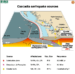
Thompson, Jerry. 2011. Cascadia’ Fault: The Earthquake and Tsunami That Could Devastate North America. Berkeley, CA: Counterpoint Press.
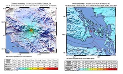
Matheson, Darcy Wintonyk; and Weichel, Andrew. 30 December 2015. “Overnight Quake the Strongest Felt in 14 Years on B.C.’s South Coast.” CTV News Vancouver > News.
- Available @ http://bc.ctvnews.ca/overnight-quake-the-strongest-felt-in-14-years-on-b-c-s-south-coast-1.2717808


 News Photo by Kevin Galvin")
 and NEHRP (National Earthquake Hazards Reduction Program)")


 Mailing Addresses for 2025 Form 4868 Extending 1040 and 1040SR April 15, 2026, Due Dateon 04/02/2026
 Mailing Addresses for 2025 Forms 1040 and 1040SR Filed in 2026on 03/31/2026
 Are Hawaiian Huakai Po Nightmarchers Avenging Halloween Thursday?on 10/02/2024
 Mailing Addresses for 2023 Form 4868 Extending 1040 and 1040SR April 15, 2024, Due Dateon 04/15/2024
Comments
The American western coastline perhaps archives ancient artifacts of ancient earthquakes, from Alaska through Central and South America.
There's an argument in IberoAmerican archaeology about western coastal earthquakes interrupting the afore-indicated biogeography of such ancient cultures as the Chavin of Peru and the Maya of Guatemala and Mexico.
Quipu is more than a counting implement. It lodges cultural and literary information.
Mightn't quipu matter in western-coastal American earthquake history and reconstruction?
WriterArtist, Thank you for stopping by and writing such an interesting account of your unsettling experience with the ground ceasing to be secure under one's feet.
My recentest experience is a bit less scary than yours since it took place during the day in the university library stacks. The carpeted floor moved quickly back and forth under my feet! And that was all there was to it where I was even as it was longer than a second and scarier elsewhere.
With irreversible climate changes, we all are not immune of havocs caused by tsunami and earthquakes. My earliest experiences with earthquake was small tremors felt at midnight. I was a student then, my roommates came out of their hostel rooms and gathered in panic. Company of others gave courage and we could call it off when the vibrations stopped after sometime. I vividly remember the shaking of ground and my bed vibrating along with the chair and table.
I can understand how catastrophic a earthquake can be be with its casualties and shocking waves. Japan for one, has taken preventive steps to tackle earthquake disasters.
frankbeswick, Is it a case of the unknown earthquake casualty or is the person's name known? I've been through two, one in Utah and another in Virginia (about which I wrote for Wizzley). In both cases, the floor moved back and forth quickly under my feet, almost like the experience of skating backward and forward.
Britain does not suffer very bad quakes, I have only personally experienced three, the worst being a magnitude 2, which was part of an earthquake cluster of mainly magnitude ones, though we have had larger. No one was hurt, in fact Britain's recorded death toll from quakes is one, in the eighteenth century.
Cumbre Vieja will cause Atlantic-wide problems, but when we don't now. However, by the time the wave hits Britain it will have diminished in size, and it is Eastern America that will take the brunt. Our South Coast has cliffs that can take a direct hit. But any tsunami coming from the South West will vary in its effects according to the varying sea bed and coastal conditions that it meets on its way.
frankbeswick, Yikes! I hope that the United Kingdom has effective earthquake and tsunami preparedness.
Speaking of Krakatoa, did you know that some scientists believe that the sky in Edvard Munch's The Scream art work reflects the influence of that volcanic eruption on Oslo's skies? There's a recent alternate interpretation of it as mother-of-pearl cloud configurations in an article by Mariëtte Le Roux, Weird Clouds May Have Inspired 'The Scream,' for Phys.Org April 24, 2017.
It is not widely known that the tsunami from Krakatoa hit Britain. Ok, by that time it was 4 centimetres high, but it was measured. I have thought about the issue and am concerned that any shock might cause Cumbre Vieja, a volcanic island off Africa, to have a submarine landslide, which will cause tsunamis to hit the Eastern USA and the coast of Britain.Some time in the next ten thousand years it will happen, but I can wait. But it could happen any time, and I have a daughter who dwells near the coast in West Britain.
frankbeswick, Amen! It's a scary scenario if all the weak points from coastal and offshore Canada, the United States and Mexico become actively problematic at the same time and if area nuclear power stations find their back-ups failing like Fukushima's did.
A mega-quake would have repercussions across the whole Pacific region, possibly with world wide implications.
CruiseReady, The truly scary version is a mega-earthquake that runs from coastal North America down through Central America!